Approximate Location Map
Large Map »
This site is entirely user-supported. See how you can help.
Latitude: 50.1315 / 50°7'53"N
Longitude: -5.5649 / 5°33'53"W
OS Eastings: 145326.280425
OS Northings: 31801.834591
OS Grid: SW453318
Mapcode National: GBR DXMB.KRM
Mapcode Global: VH059.HYDK
Entry Name: Wayside cross in Madron churchyard, west of the church
Scheduled Date: 15 April 1970
Last Amended: 24 September 1997
Source: Historic England
Source ID: 1016157
English Heritage Legacy ID: 30407
County: Cornwall
Civil Parish: Madron
Built-Up Area: Madron
Traditional County: Cornwall
Lieutenancy Area (Ceremonial County): Cornwall
Church of England Parish: Madron
Church of England Diocese: Truro
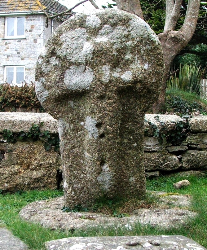
The monument includes a medieval wayside cross situated to the west of the
church at Madron on the Penwith peninsula in west Cornwall.
The wayside cross, which is listed Grade II, is visible as an upright granite
shaft with a round or `wheel' head, mounted on a circular granite base. The
monument measures 0.97m in overall height. The head measures 0.62m wide by
0.24m thick. The principal faces are orientated east-west and are decorated.
The east principal face bears a large figure of Christ, 0.84m high, with
outstretched arms, the legs and lower part of the body extending down the
shaft. The ends of the arms are expanded, showing the sleeves of the tunic,
and the feet are missing. There are four shallow holes or drillings on the
figure of Christ motif. The west principal face bears a relief equal limbed
cross with slightly expanded ends to the limbs; two incised lines continue the
lower limb down the length of the shaft. There is a narrow bead around the
outer edge of the head on this face. There is a 0.04m diameter hole, 0.07m
deep in the shaft, just below the head, probably the result of an earlier
reuse of the cross as a gatepost. There is a similar hole in the south side of
the top of the head. The shaft is mounted in a circular base, 0.95m in
diameter, which is set flush with the ground. This base consists of two pieces
of granite with many shallow holes being sunk into it, the result of its
previous use as a practise stone for young men to practice drilling holes in
granite prior to starting work in the quarries. The four holes on the figure
of Christ are also a result of this reuse of the cross.
This wayside cross was recorded by the antiquarian Blight in the mid-1850s as
being built into a hedge near the east entrance to the churchyard at Madron.
By 1896, when the historian Langdon illustrated the cross, it had been mounted
in a base and relocated at the west end of the churchyard in its present
position.
The electricity cable to the west of the cross, the headstones to the north,
north east, and east, and the granite and brick structure to the south, are
excluded from the scheduling, although the ground beneath, these features is
included.
MAP EXTRACT
The site of the monument is shown on the attached map extract.
It includes a 2 metre boundary around the archaeological features,
considered to be essential for the monument's support and preservation.
Source: Historic England
Wayside crosses are one of several types of Christian cross erected during the
medieval period, mostly from the 9th to 15th centuries AD. In addition to
serving the function of reiterating and reinforcing the Christian faith
amongst those who passed the cross and of reassuring the traveller, wayside
crosses often fulfilled a role as waymarkers, especially in difficult and
otherwise unmarked terrain. The crosses might be on regularly used routes
linking ordinary settlements or on routes having a more specifically religious
function, including those providing access to religious sites for parishioners
and funeral processions, or marking long-distance routes frequented on
pilgrimages.
Over 350 wayside crosses are known nationally, concentrated in south west
England throughout Cornwall and on Dartmoor where they form the commonest type
of stone cross. A small group also occurs on the North York Moors. Relatively
few examples have been recorded elsewhere and these are generally confined to
remote moorland locations.
Outside Cornwall almost all wayside crosses take the form of a `Latin' cross,
in which the cross-head itself is shaped within the projecting arms of an
unenclosed cross. In Cornwall wayside crosses vary considerably in form and
decoration. The commonest type includes a round, or `wheel', head on the faces
of which various forms of cross or related designs were carved in relief or
incised, the spaces between the cross arms possibly pierced. The design was
sometimes supplemented with a relief figure of Christ and the shaft might bear
decorative panels and motifs. Less common forms in Cornwall include the
`Latin' cross and, much rarer, the simple slab with a low relief cross on both
faces. Rare examples of wheel-head and slab-form crosses also occur within the
North York Moors group. Most wayside crosses have either a simple socketed
base or show no evidence for a separate base at all.
Wayside crosses contribute significantly to our understanding of medieval
religious customs and sculptural traditions and to our knowledge of medieval
routeways and settlement patterns. All wayside crosses which survive as earth-
fast monuments, except those which are extremely damaged and removed from
their original locations, are considered worthy of protection.
This wayside cross has survived well as a good example of a `wheel' headed
cross with a rare figure of Christ motif on one face. Its reuse as a gatepost
and relocation in the churchyard at Madron illustrates well the changing
attitudes to religion and their impact on the local landscape since the
medieval period.
Source: Historic England
Books and journals
Langdon, A G, Old Cornish Crosses, (1896)
Other
Consulted July 1996, Cornwall SMR entry for PRN No.31702,
Title: 1:25000 Ordnance Survey Map; SW33/43; Pathfinder Series 1364
Source Date: 1989
Author:
Publisher:
Surveyor:
Source: Historic England
Other nearby scheduled monuments