Approximate Location Map
Large Map »
This site is entirely user-supported. See how you can help.
Latitude: 51.1945 / 51°11'40"N
Longitude: -2.5169 / 2°31'0"W
OS Eastings: 363977.124
OS Northings: 144049.775
OS Grid: ST639440
Mapcode National: GBR MV.504G
Mapcode Global: VH8B1.B78M
Entry Name: Medieval wayside cross at Bodden
Scheduled Date: 13 June 1977
Last Amended: 8 April 1997
Source: Historic England
Source ID: 1015798
English Heritage Legacy ID: 29768
County: Somerset
Civil Parish: Doulting
Traditional County: Somerset
Lieutenancy Area (Ceremonial County): Somerset
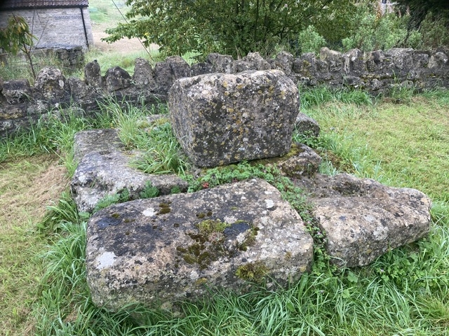
The monument includes a cross situated on a roadside verge at a crossroads at
Bodden. The cross includes a square base, c.2.4m square, made of two courses
of stone, although not all of the second course survives. Above the base is a
square socket stone, 0.8m square and 0.6m high with broad convex broaches at
the top corners. The top face of the socket stone has been damaged but the
remains of the socket, c.0.4m across, still survive. The cross is considered
to be 14th century in date and is Listed Grade II.
MAP EXTRACT
The site of the monument is shown on the attached map extract.
It includes a 1 metre boundary around the archaeological features,
considered to be essential for the monument's support and preservation.
Source: Historic England
Wayside crosses are one of several types of Christian cross erected during the
medieval period, mostly from the 9th to 15th centuries AD. In addition to
serving the function of reiterating and reinforcing the Christian faith
amongst those who passed the cross and of reassuring the traveller, wayside
crosses often fulfilled a role as waymarkers, especially in difficult and
otherwise unmarked terrain. The crosses might be on regularly used routes
linking ordinary settlements or on routes having a more specifically religious
function, including those providing access to religious sites for parishioners
and funeral processions, or marking long-distance routes frequented on
pilgrimages.
Over 350 wayside crosses are known nationally, concentrated in south west
England throughout Cornwall and on Dartmoor where they form the commonest type
of stone cross. A small group also occurs on the North York Moors. Relatively
few examples have been recorded elsewhere and these are generally confined to
remote moorland locations.
Outside Cornwall almost all wayside crosses take the form of a `Latin' cross,
in which the cross-head itself is shaped within the projecting arms of an
unenclosed cross. In Cornwall wayside crosses vary considerably in form and
decoration. The commonest type includes a round, or `wheel', head on the faces
of which various forms of cross or related designs were carved in relief or
incised, the spaces between the cross arms possibly pierced. The design was
sometimes supplemented with a relief figure of Christ and the shaft might bear
decorative panels and motifs. Less common forms in Cornwall include the
`Latin' cross and, much rarer, the simple slab with a low relief cross on both
faces. Rare examples of wheel-head and slab-form crosses also occur within the
North York Moors group. Most wayside crosses have either a simple socketed
base or show no evidence for a separate base at all.
Wayside crosses contribute significantly to our understanding of medieval
religious customs and sculptural traditions and to our knowledge of medieval
routeways and settlement patterns. All wayside crosses which survive as earth-
fast monuments, except those which are extremely damaged and removed from
their original locations, are considered worthy of protection.
Despite the shaft not surviving, the standing cross at Bodden survives in what
is likely to be its original location and remains an important example of its
class.
Source: Historic England
Other nearby scheduled monuments