Approximate Location Map
Large Map »
This site is entirely user-supported. See how you can help.
Latitude: 50.6946 / 50°41'40"N
Longitude: -2.4705 / 2°28'13"W
OS Eastings: 366866.073188
OS Northings: 88438.017631
OS Grid: SY668884
Mapcode National: GBR PX.MYQB
Mapcode Global: FRA 57Q7.MCF
Entry Name: Maiden Castle
Scheduled Date: 9 October 1981
Last Amended: 24 September 1997
Source: Historic England
Source ID: 1015775
English Heritage Legacy ID: 22959
County: Dorset
Civil Parish: Winterborne St. Martin
Traditional County: Dorset
Lieutenancy Area (Ceremonial County): Dorset
Church of England Parish: The Winterbournes
Church of England Diocese: Salisbury
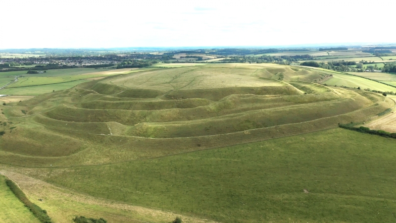
Maiden Castle, known primarily for its Iron Age hillfort, includes multi-
period remains on a chalk hilltop of the South Dorset Downs, overlooking the
valleys of the rivers Frome and South Winterborne. The site was partly
excavated by Edward Cunnington (1884) and Sir Mortimer Wheeler (1934-37),
revealing that the hilltop had been occupied over a long period. Additional
investigations conducted during 1985-6 included further part excavations and a
programme of environmental sampling.
The earliest features to be identified at the site include a group of pits
across the hilltop, associated with Early Neolithic flintwork. Environmental
evidence suggests that the pits date to around 4000 BC, a time when the
hilltop was first cleared of woodland. Soon after this, a causewayed enclosure
was constructed on the eastern plateau, enclosing an area of about 8ha. The
enclosure was defined by two concentric lines of ditch, constructed as a
series of irregular segments situated 14m-15m apart. The inner ditch is 3m-4m
wide and was constructed as segments later joined together. The outer ditch is
1.7m-2.4m wide and constructed as segments associated with causeways 5m-6m
wide. The enclosure may have contained a long barrow and is associated with
two human infant burials.
Around 3500 BC, and after the enclosure had fallen out of use, a bank barrow
was constructed near to the centre of the hilltop, part of it overlying the
western end of the causewayed enclosure. The barrow has a mound 546m long,
17.5m wide and 0.5m-1m high, composed of earth, flint and chalk. The mound
has three sections and may have developed from an earlier long barrow. The
central mound is 65m long and approximately 1m high, with an extension to the
east and west. The mound has a quarry ditch 5.5m wide and c.1.5m deep on
either side. During the Later Neolithic and Bronze Age periods, archaeological
evidence suggests that human occupation of the hilltop continued, although
probably on a reduced scale. The two bowl barrows and small enclosure situated
near the centre of the hilltop are of this period. Environmental evidence
indicates pastoral conditions at this time.
The hillfort overlies the earlier Neolithic causewayed enclosure and is known
to have had a complex development history. Initially it was defined by a
single rampart in the form of a chalk bank 6.6m wide and c.3m high, an outer
ditch 15m wide and c.6m deep and an intervening berm, or gently sloping
platform, 3m wide. The ramparts enclosed an area of 6.5ha and were broken by
entrances to the east and west, both guarded by timber gates.
During the second half of the 3rd century BC the ramparts were extended
around the hilltop to enclose an area of 20ha, and during the mid-2nd century
BC the ramparts were rebuilt on a larger scale: the bank was increased in size
and a second ditch added to the south. Following several remodellings, the
ramparts finally consisted of three banks and two ditches around the hilltop,
with an extra bank and ditch along the gentler slope to the south. The
interior of the hillfort is known to have been intensively occupied. Traces of
circular and rectangular huts and buildings are known from post holes,
trenches and floor remains. The largest circular example situated within the
eastern area of the fort, may have later been developed into a shrine. Roads,
gullies, ponds, storage pits and ovens have been identified in association
with the structures.
Finds from the hillfort include several large groups of sling stones, large
quantities of Iron Age pottery, brooches, beads, spinning whorls, loom
weights, weaving combs, bone horse-bit cheek pieces, worked Kimmeridge shale,
quern and saddle stones and 19 Celtic coins. Around 50 human burials have been
identified, many within a cemetery at the east end of the monument. The later
burials are sometimes associated with grave goods including pots, axe heads,
and knives as well as the bones of ox, pig and sheep.
Following the Roman Conquest, occupation of the hilltop declined and the Roman
town of Durnovaria was established to the north east at Dorchester. However, a
Romano-Celtic temple was constructed at the eastern end of the fort during the
4th century AD. The building, built of flint and limestone, comprised a
central block (or cella) 6m square, surrounded by a corridor or verandah 2.5m
wide, within a walled precinct 13m by 12m in plan. The cella may have had a
black and white mosaic floor and the corridor had a red tesserated pavement.
The structure was roofed in stone tiles, later replaced by clay. The
dedication of the temple is unknown, but is most likely to have been to a
pagan deity.
In the post-Roman period, the hilltop was used for grazing of stock and
several dew ponds were constructed to provide water. During the 17th century
the hilltop was ploughed, but there is no evidence that the hilltop has been
cultivated during the last two centuries.
Excluded from the scheduling are the Nissan huts within the north western
area, the gates and fence posts relating to the modern field boundaries and
all notice boards, although the ground beneath these features is included.
MAP EXTRACT
The site of the monument is shown on the attached map extract.
Source: Historic England
Large multivallate hillforts are defined as fortified enclosures of between
5ha and 85ha in area, located on hills and defined by two or more lines of
concentric earthworks set at intervals of up to 15m. They date to the Iron
Age period, most having been constructed and used between the sixth century BC
and the mid-first century AD. They are generally regarded as centres of
permanent occupation, defended in response to increasing warfare, a reflection
of the power struggle between competing elites.
Earthworks usually consist of a rampart and ditch, although some only have
ramparts. Access to the interior is generally provided by two entrances
although examples with one and more than two have been noted. These may
comprise a single gap in the rampart, inturned or offset ramparts,
oblique approaches, guardrooms or outworks. Internal features generally
include evidence for intensive occupation, often in the form of oval or
circular houses. These display variations in size and are often clustered,
for example, along streets. Four- and six-post structures, interpreted as
raised granaries, also occur widely while a few sites appear to contain
evidence for temples. Other features associated with settlement include
platforms, paved areas, pits, gullies, fencelines, hearths and ovens.
Additional evidence, in the form of artefacts, suggests that industrial
activity such as bronze- and iron-working as well as pottery manufacture
occurred on many sites.
Large multivallate hillforts are rare with around 50 examples recorded
nationally. These occur mostly in two concentrations, in Wessex and the Welsh
Marches, although scattered examples occur elsewhere.
In view of the rarity of large multivallate hillforts and their importance in
understanding the nature of social organisation within the Iron Age period,
all examples with surviving archaeological potential are believed to be of
national importance.
Maiden Castle is an outstanding example of its class, surviving well and
acting as a landmark in the local area. Its history is well known, having been
the subject of investigations over the years by, amongst others, Sir Mortimer
Wheeler.
Although known primarily as a hillfort, the Neolithic deposits represent some
of the earliest monumental remains in the area. Causewayed enclosures and bank
barrows are rare forms of monument nationally and their association at Maiden
Castle is one of only two cases to be identified. The Neolithic monuments at
Maiden Castle exerted an influence upon the location of monuments to the
north: two long barrows were aligned upon the bank barrow, and these later
formed foci for Bronze age round barrow cemeteries.
During the Iron Age, the hilltop was progressively developed into one of the
largest hillforts in Britain. The hillfort is particularly noted for the scale
and extent of the outer ramparts and well developed entrance earthworks.
Excavation has demonstrated the survival of extensive buried deposits
including structural foundations and occupation debris within the centre of
the hilltop. This has enabled a detailed insight into the nature of the use
and development of the hilltop and lifestyles of the successive communities
associated with it. Excavation has produced rare traces of Roman military
equipment dating to the period of the Roman invasion. This includes the famous
find of a ballista within the vertebrae of an adult man. The hilltop continued
to be utilised later in the Romano-British period and a Romano-Celtic temple
was established near to an earlier pre-Roman shrine.
Maiden Castle is a well known and much visited monument, about which much has
been written over the years. Its connection with the history of English
literature, through reference in the novels of Thomas Hardy, contributes to
its popularity.
Source: Historic England
Books and journals
Historical Monuments in the County of Dorset: Volume I, (1970), 501
Historical Monuments in the County of Dorset: Volume I, (1970), 493
Historical Monuments in the County of Dorset: Volume I, (1970), 471
Historical Monuments in the County of Dorset: Volume I, (1970), 498-9
Historical Monuments in the County of Dorset: Volume I, (1970), 500
Historical Monuments in the County of Dorset: Volume I, (1970), 495
Historical Monuments in the County of Dorset: Volume I, (1970), 500
Historical Monuments in the County of Dorset: Volume I, (1970), 501
Historical Monuments in the County of Dorset: Volume I, (1970), 499
Historical Monuments in the County of Dorset: Volume I, (1970), 493
Historical Monuments in the County of Dorset: Volume I, (1970), 501
Historical Monuments in the County of Dorset: Volume I, (1970), 493
Historical Monuments in the County of Dorset: Volume I, (1970), 495
Historical Monuments in the County of Dorset: Volume I, (1970), 497
Historical Monuments in the County of Dorset: Volume I, (1970), 495
Historical Monuments in the County of Dorset: Volume I, (1970), 495
Historical Monuments in the County of Dorset: Volume I, (1970), 495
Historical Monuments in the County of Dorset: Volume I, (1970), 500
Historical Monuments in the County of Dorset: Volume I, (1970), 500
Historical Monuments in the County of Dorset: Volume I, (1970), 501
Historical Monuments in the County of Dorset: Volume I, (1970), 501
Historical Monuments in the County of Dorset: Volume I, (1970), 493
Historical Monuments in the County of Dorset: Volume I, (1970), 499
Historical Monuments in the County of Dorset: Volume I, (1970), 495
Historical Monuments in the County of Dorset: Volume I, (1970), 495
Historical Monuments in the County of Dorset: Volume I, (1970), 495
Historical Monuments in the County of Dorset: Volume I, (1970), 493
Historical Monuments in the County of Dorset: Volume I, (1970), 501
Historical Monuments in the County of Dorset: Volume I, (1970), 495
Historical Monuments in the County of Dorset: Volume I, (1970), 496
Historical Monuments in the County of Dorset: Volume I, (1970), 495
Historical Monuments in the County of Dorset: Volume I, (1970), 493
Historical Monuments in the County of Dorset: Volume I, (1970), 498
Historical Monuments in the County of Dorset: Volume I, (1970), 502
Historical Monuments in the County of Dorset: Volume I, (1970), 497
Historical Monuments in the County of Dorset: Volume I, (1970), 501
Historical Monuments in the County of Dorset: Volume I, (1970), 498
Historical Monuments in the County of Dorset: Volume I, (1970), 500
Historical Monuments in the County of Dorset: Volume I, (1970), 495
Historical Monuments in the County of Dorset: Volume I, (1970), 502
Historical Monuments in the County of Dorset: Volume I, (1970), 493
Historical Monuments in the County of Dorset: Volume I, (1970), 501
Historical Monuments in the County of Dorset: Volume I, (1970), 501
Historical Monuments in the County of Dorset: Volume I, (1970), 501
Historical Monuments in the County of Dorset: Volume I, (1970), 501
Historical Monuments in the County of Dorset: Volume I, (1970), 501
Historical Monuments in the County of Dorset: Volume I, (1970), 501
Historical Monuments in the County of Dorset: Volume I, (1970), 501
Sharples, N M, Maiden Castle: Excavation and field survey 1985-6, (1991), 41
Sharples, N M, Maiden Castle: Excavation and field survey 1985-6, (1991), 41
Sharples, N M, Maiden Castle: Excavation and field survey 1985-6, (1991), 38
Sharples, N M, Maiden Castle: Excavation and field survey 1985-6, (1991), 38
Sharples, N M, Maiden Castle: Excavation and field survey 1985-6, (1991), 38
Sharples, N M, Maiden Castle: Excavation and field survey 1985-6, (1991), 38
Sharples, N M, Maiden Castle: Excavation and field survey 1985-6, (1991), 102
Sharples, N M, Maiden Castle: Excavation and field survey 1985-6, (1991), 41
Sharples, N M, Maiden Castle: Excavation and field survey 1985-6, (1991), 123
Sharples, N M, Maiden Castle: Excavation and field survey 1985-6, (1991), 41
Sharples, N M, Maiden Castle: Excavation and field survey 1985-6, (1991), 43
Sharples, N M, Maiden Castle: Excavation and field survey 1985-6, (1991), 49
Sharples, N M, Maiden Castle: Excavation and field survey 1985-6, (1991), 48
Sharples, N M, Maiden Castle: Excavation and field survey 1985-6, (1991), 54
Sharples, N M, Maiden Castle: Excavation and field survey 1985-6, (1991), 53
Sharples, N M, Maiden Castle: Excavation and field survey 1985-6, (1991), 54
Sharples, N M, Maiden Castle: Excavation and field survey 1985-6, (1991), 54
Sharples, N M, Maiden Castle: Excavation and field survey 1985-6, (1991), 49
Other
Title: Ordnance Survey 1:2500 Series
Source Date: 1955
Author:
Publisher:
Surveyor:
Mapped depiction of pond
Source: Historic England
Other nearby scheduled monuments