Approximate Location Map
Large Map »
This site is entirely user-supported. See how you can help.
Latitude: 51.5383 / 51°32'17"N
Longitude: -1.6015 / 1°36'5"W
OS Eastings: 427735.591244
OS Northings: 182230.808065
OS Grid: SU277822
Mapcode National: GBR 5X6.HY5
Mapcode Global: VHC15.6L6L
Entry Name: Alfred's Castle univallate hillfort
Scheduled Date: 11 February 1958
Last Amended: 4 March 1997
Source: Historic England
Source ID: 1015551
English Heritage Legacy ID: 28163
County: Oxfordshire
Civil Parish: Ashbury
Traditional County: Berkshire
Lieutenancy Area (Ceremonial County): Oxfordshire
Church of England Parish: Ashbury
Church of England Diocese: Oxford
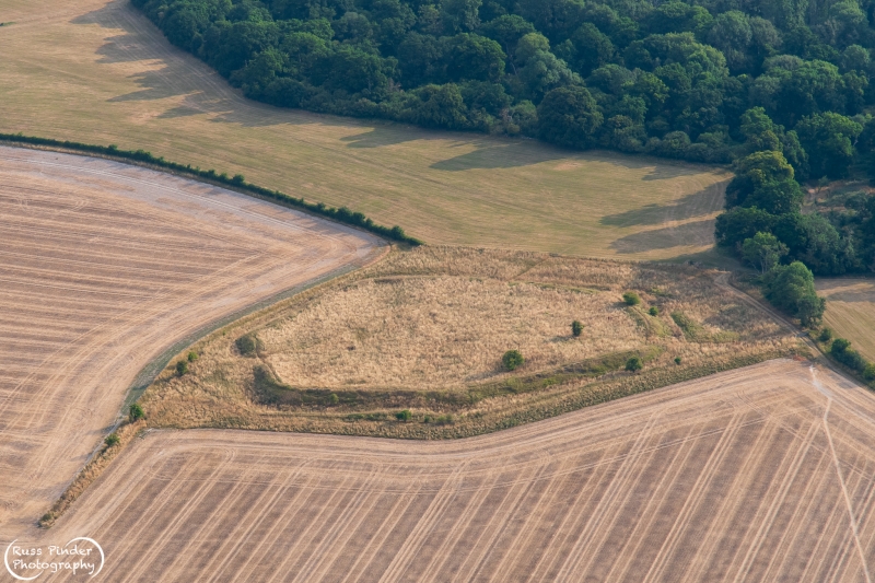
The monument includes a roughly polygonal univallate hillfort known as
Alfred's Castle, situated c.500m north west of Ashdown House. The earthwork
defences consist of a single rampart bank which measures between 3m and 10m
wide and stands up to 1.5m high. It was originally revetted with sarsen walls
which can still be seen in places. Beyond the rampart lies a ditch which is
believed to have been built as a series of lengths with gaps between them. The
ditch sections measure up to 1.5m deep below ground level, with the drop from
the top of the rampart to the bottom of the ditch being at least 2.5m. The
ditch varies greatly in width, but its average would have originally been
c.10m.
The area enclosed measures c.136m across and currently has three entrances
situated on the north east, south east and north west corners. Only the south
east entrance is certainly original and here is defended by further outworks
consisting of a hollow way approach through a second rampart bank which
survives as an upstanding, roughly triangular-shaped feature.
Within the interior are a series of features which appear to represent stone
building foundations. However, it is unclear whether those which are visible
represent the original buildings or a later reuse of the site.
Excluded from the monument is the boundary fence which crosses the ditch,
although the ground beneath is included.
MAP EXTRACT
The site of the monument is shown on the attached map extract.
It includes a 2 metre boundary around the archaeological features,
considered to be essential for the monument's support and preservation.
Source: Historic England
Slight univallate hillforts are defined as enclosures of various shapes,
generally between 1ha and 10ha in size, situated on or close to hilltops and
defined by a single line of earthworks, the scale of which is relatively
small. They date to between the Late Bronze Age and Early Iron Age (eighth -
fifth centuries BC), the majority being used for 150 to 200 years prior to
their abandonment or reconstruction. Slight univallate hillforts have
generally been interpreted as stock enclosures, redistribution centres, places
of refuge and permanent settlements. The earthworks generally include a
rampart, narrow level berm, external ditch and counterscarp bank, while access
to the interior is usually provided by two entrances comprising either simple
gaps in the earthwork or an inturned rampart. Postholes revealed by excavation
indicate the occasional presence of portal gateways while more elaborate
features like overlapping ramparts and outworks are limited to only a few
examples. Internal features included timber or stone round houses; large
storage pits and hearths; scattered postholes, stakeholes and gullies; and
square or rectangular buildings supported by four to six posts, often
represented by postholes, and interpreted as raised granaries. Slight
univallate hillforts are rare with around 150 examples recorded nationally.
Although on a national scale the number is low, in Devon they comprise one of
the major classes of hillfort. In other areas where the distribution is
relatively dense, for example, Wessex, Sussex, the Cotswolds and the
Chilterns, hillforts belonging to a number of different classes occur within
the same region. Examples are also recorded in eastern England, the Welsh
Marches, central and southern England. In view of the rarity of slight
univallate hillforts and their importance in understanding the transition
between Bronze Age and Iron Age communities, all examples which survive
comparatively well and have potential for the recovery of further
archaeological remains are believed to be of national importance.
Alfred's Castle survives as a good example of its class. It will contain
archaeological and environmental evidence relating to its construction and the
landscape in which it was built. In addition, it is open to the public and
forms an important educational amenity.
Source: Historic England
Other
PRN 7333, C.A.O., Alfred's Castle, (1993)
Source: Historic England
Other nearby scheduled monuments