Approximate Location Map
Large Map »
This site is entirely user-supported. See how you can help.
Latitude: 53.1843 / 53°11'3"N
Longitude: -2.8892 / 2°53'21"W
OS Eastings: 340673.987646
OS Northings: 365613.460851
OS Grid: SJ406656
Mapcode National: GBR 7B.3DNW
Mapcode Global: WH88F.L7D5
Entry Name: Roman quarry including Edgar's Cave and the rock-cut figure of Minerva on Edgar's Field, 150m south west of Dee Bridge
Scheduled Date: 13 December 1929
Last Amended: 19 September 1996
Source: Historic England
Source ID: 1014718
English Heritage Legacy ID: 27582
County: Cheshire West and Chester
Electoral Ward/Division: Handbridge Park
Built-Up Area: Chester
Traditional County: Cheshire
Lieutenancy Area (Ceremonial County): Cheshire
Church of England Parish: Chester St Mary without the Walls
Church of England Diocese: Chester
The monument includes a Roman quarry face on which is carved a figure of the
Roman goddess Minerva. A cave is cut into the rock face behind the figure and
forms a shrine for votive offerings. This is known as Edgar's Cave. The rock
outcrop bearing the carving and cave are now surrounded by a park with a
childrens' playground in the centre and the grass around the monument is cut
as a lawn. An area of the floor of the quarry is also included.
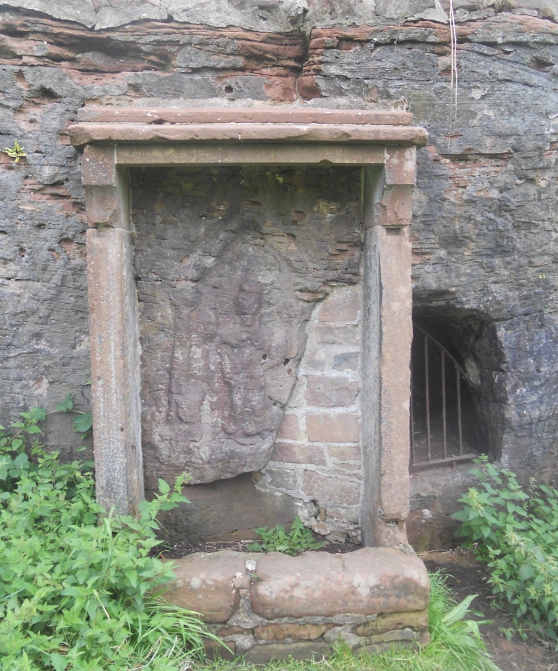
The relief sculpted figure, which is also Listed Grade II, stands 1.45m high
and 0.73m wide. It has been enclosed by a sandstone frame which originally
held a steel gate across the front of the sculpture to protect it from
vandalism. To the right of the frame, the cave is cut into the rock face; to
the left it is built up with freestone to support it from behind. The entrance
to the cave is now closed with a steel grill. The top of the rock face has
been capped with stone setts.
The exposed rock face is part of a more extensive quarry which curves around
the ground known as Edgar's Field forming a slope with two terraces on the
southern and western sides. Excavations in the early 1920s revealed that the
quarry was in use c.100 AD. Soil was imported to cover the quarry floor in
the late-second century AD. Roman occupation remains dating from that time on
were found on the site. Subsequently stone was quarried from the site again
during the Middle Ages.
The sculpted shrine and figure of the goddess would appear to have been carved
during the working of the quarry. It may have been adopted as a Christian
shrine in later centuries which would account for the remarkable preservation
of the figure and its surround.
The shrine has a signboard on wooden uprights to the left of the frame. The
signboard and its uprights are excluded from the scheduling but the ground
beneath them is included.
MAP EXTRACT
The site of the monument is shown on the attached map extract.
Source: Historic England
The Roman conquest of Britain brought a signficant increase in the requirement
for building stone and generated the first major quarrying industry to be
developed in England. Quarries were opened and exploited from soon after the
conquest to the end of the Roman period in the fifth century. The majority
were used for a very limited period of time and met the requirements for
building stone within their immediate areas. A few, including the Purbeck
marble quarries, produced very high quality building stone which was
transported for use over a wide area. Many were under military control to
produce stone for forts or defence works such as Hadrian's Wall. Others were
under the control of town authorities. In some instances they may also have
been privately owned. Most provided building stone, but a few were used for
more specific purposes to produce quern or mill stones.
Quarrying techniques were relatively simple and involved the use of wedges,
separation trenches and percussion to split lumps of rock from the parent
material. Irregular blocks of stone were usually dressed to shape before being
transported from the quarries. Tracks and pathways enabling the removal of
stone from the quarry would also have existed. Visible remains include working
faces, waste heaps and dressing floors.
Today, however, very few Roman quarries can be positively identified because
reuse in later times has removed much evidence for Roman activity, whilst the
continued use of similar quarrying techniques over long periods often makes it
impossible to determine the exact date of surviving remains.
Most of the quarries which are considered to be Roman are dated on the basis
of surviving inscriptions or carvings, usually on the worked face. Fewer than
50 quarries have been confirmed to retain evidence for Roman activity. In view
of their rarity and the insights they provide into Roman technology and
building works, all surviving examples will be identified to be nationally
important.
The Roman quarry and shrine in Edgar's field is a unique survival in the
British Isles. The quarry has been securely dated by an archaeological
excavation to an early period of the Roman occupation coincident with the
building in stone of the legionary fortress at Chester and the shrine is
unusual in having survived the arrival of Christianity and later quarrying in
the area.
Source: Historic England
Books and journals
Newstead, R, 'Journal Chester Archaeological Society' in Edgars Field Handbridge Site LXIII, (1926), 103-51
Newstead, R, 'Journal Chester Archaeological Society' in Edgars Field Handbridge Site LXIII, (1926), 103-151
Smith, R, 'Journal British Archaeological Association' in , , Vol. V, (), 215
Source: Historic England
Other nearby scheduled monuments