Approximate Location Map
Large Map »
This site is entirely user-supported. See how you can help.
Latitude: 53.2986 / 53°17'54"N
Longitude: -1.7703 / 1°46'13"W
OS Eastings: 415406.739755
OS Northings: 377984.852159
OS Grid: SK154779
Mapcode National: GBR JZ29.J8
Mapcode Global: WHCCS.SC62
Entry Name: Tideslow Rake lead rake and lime kiln
Scheduled Date: 26 September 1986
Last Amended: 18 March 1996
Source: Historic England
Source ID: 1014591
English Heritage Legacy ID: 27217
County: Derbyshire
Civil Parish: Tideswell
Traditional County: Derbyshire
Lieutenancy Area (Ceremonial County): Derbyshire
Church of England Parish: Tideswell St John the Baptist
Church of England Diocese: Derby
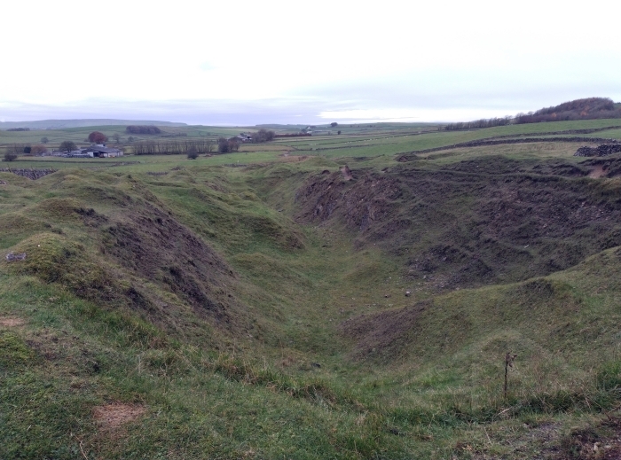
Tideslow Rake is situated in the north western uplands of the limestone
plateau of Derbyshire. The monument includes part of the lead rake and an
associated lime kiln. The extreme western end of the rake is not included in
the scheduling as the remains there have been disturbed by modern fluorspar
extraction.
The rake forms a complex linear leadworking feature comprising both
mineworkings and associated ore works. The primary feature is a large opencut,
representing the working of a lead vein. This extends intermittently for the
length of the rake and is flanked all the way by shafts, heaps of dressing
waste and spoil, numerous dressing and washing floors and platforms for
winding gear.
The whole site is criss-crossed with tracks leading between features and from
off site. These include, in the area round Tides Low, two inclines which may
have been used for rope-controlled movement of materials up and down the rake.
In the same area, approaching from Tides Low barrow, there is a track with the
remains of flanking walls. A similar walled track heads west at right angles
to this along the top of Tideslow plantation.
Towards the western end of the rake, there is a complex of very well preserved
shaft mounds, each incorporating a shaft and an integral platform for winding
gear. One of these, c.120m north of Tides Low, stands next to a shaft capped
with railway sleepers and includes metalwork which will have been part of a
winding mechanism. The same area also includes the foundations of a number of
small rectangular buildings known as coes and used for purposes such as
storage and ore-breaking. At least two of these coes, lying south east of the
capped shaft noted above, contain mine shafts. One of these shafts is covered
by a collapsed beehive cap.
To the north of this complex of shafts and coes there is a large flat-topped
earthwork incorporating a gin-circle. Gin-circles were formerly the sites of
horse-powered winding gear or gins. Immediately west of the gin-circle is a
narrow leat or watercourse which ends in a buddle and has other leats leading
off at right angles. Buddles were constructions used to separate finer ore
from lighter waste using a current of water. These water management features
are associated with a group of 1m deep rectangular pits interpreted as
settling tanks. Their occurrence near the gin-circle implies that the gin may
have been used to raise water for the washing and separating of dressed ore.
Coes in the same vicinity occur next to small dressing or washing floors. In
addition, there is a triangular pond downslope to the east which has also been
interpreted as a settling tank used in the separation of ore from waste
deposits.
An incline leading east round the south side of the pond eventually meets up
with another track crossing the rake from north to south. At the junction of
these two thoroughfares there are the remains of a collapsed lime kiln of the
type known as a `pudding' or `pie' kiln . It is clear that this structure was
not built for occupation as the sides are too thick and the internal area too
small. Quicklime was used on leadmining sites as a cheap alternative to
gunpowder for blasting. A smaller structure, whose remains survive opposite
the lime kiln, may have been a quicklime store.
The vein at Tideslow Rake was exploited at various times between the 12th and
18th centuries but went out of use in c.1800 until parts were reworked in
modern times. The reworked parts lie outside the scheduled area. The 18th
century workings appear to be those on the high ground round Tides Low though
it is likely that earlier workings were reworked at the same time. A unique
series of legal agreements show that five drainage tunnels or `soughs' were
dug between 1648 and 1685.
Excluded from the scheduling are a radio mast and the surface of the metalled
farm track crossing the rake, although the ground beneath these features is
included.
MAP EXTRACT
The site of the monument is shown on the attached map extract.
Source: Historic England
Lead rakes are linear mining features along the outcrop of a lead vein
resulting from the extraction of relatively shallow ore. They can be broadly
divided between: rakes consisting of continuous rock-cut clefts; rakes
consisting of lines of interconnecting or closely-spaced shafts with
associated spoil tips and other features; and rakes whose surface features
were predominantly produced by reprocessing of earlier waste tips (normally in
the 19th century). In addition, some sites contain associated features such as
coes (miners' huts), gin circles (the circular track used by a horse operating
simple winding or pumping machinery), and small-scale ore-dressing areas and
structures, often marked by tips of dressing waste.
The majority of rake workings are believed to be of 16th-18th century date,
but earlier examples are likely to exist, and mining by rock-cut cleft has
again become common in the 20th century. Rakes are the main field monuments
produced by the earlier and technologically simpler phases of lead mining.
They are very common in Derbyshire, where they illustrate the character of
mining dominated by regionally distinctive Mining Laws, and moderately common
in the Pennine and Mendip orefields; they are rare in other lead mining areas.
A sample of the better preserved examples from each region, illustrating the
typological range, will merit protection.
Tideslow Rake is a well documented and visually impressive example and is a
rare survival of a lead rake which has not been reworked in recent times.
Although some of the stratigraphy of the site will have been disturbed by 18th
century reworking of earlier exploration, it is nevertheless very well
preserved and includes a wide variety of mining and ore-working features
together with a limekiln for the on site production of quicklime for blasting.
Source: Historic England
Books and journals
Harris, H, The Industrial Archaeology of the Peak District, (1971), 240
Rieuwerts, J, 'Bulletin of the Peak District Mines Historical Society' in A List of the Soughs of the Derbyshire Lead Mines, (1966), 36
Walters, S G, 'Bulletin of the Peak District Mines Historical Society' in The Geology and Mines of the Black Hillock Area, (1980), 329
Walters, S G, 'Bulletin of the Peak District Mines Historical Society' in Clear-the-Way or Black Hillock Mine, Tideslow Moor, (1980), 330
Other
Cranstone, D, The Lead Industry, Step 3 Recommendation, (1994)
Source: Historic England
Other nearby scheduled monuments