Approximate Location Map
Large Map »
This site is entirely user-supported. See how you can help.
Latitude: 53.5588 / 53°33'31"N
Longitude: -2.5678 / 2°34'4"W
OS Eastings: 362484.091916
OS Northings: 407056.14891
OS Grid: SD624070
Mapcode National: GBR BWH9.W0
Mapcode Global: WH97S.JTG4
Entry Name: Gidlow Hall moated site, Aspull, 560m NNE of Pennington Hall
Scheduled Date: 25 August 1995
Source: Historic England
Source ID: 1014210
English Heritage Legacy ID: 27586
County: Wigan
Electoral Ward/Division: Aspull New Springs Whelley
Traditional County: Lancashire
Lieutenancy Area (Ceremonial County): Greater Manchester
Church of England Parish: Aspull St Elizabeth
Church of England Diocese: Liverpool
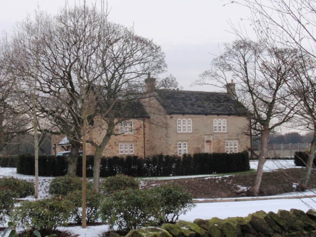
The monument includes a medieval moated site at Aspull, near Wigan. A stone
built bridge allows approach on the south side.
The water-filled moat surrounding the island is 9m wide on average and appears
to be at least 1.5m deep with little sign of silting. The moat is sub-
rectangular in shape, and has maximum dimensions of 105m north west to south
east and 75m north east to south west. A bridge allows access to the enclosed
island on the south side. This is 5m wide, built in a shallow arch of stone
and has a parapet constructed of large dressed single stones tied together
with iron clamps set in lead. The bridge is an original construction of the
late 16th century. Its width and construction could support carts and
carriages.
The platform thrown up by the excavation of the moat is raised 0.5m above the
surrounding ground level. This is divided into two areas by a hedge on a
slight bank. Otherwise there is no evidence of landscaping in the interior. At
present a square stone building two storeys high stands on the island. This
bears a date stone of 1574. It was largely rebuilt in 1840 but retains stone
mullions and moulded details from the 16th century building; it is Listed
Grade II. The 1574 building will have replaced earlier medieval buildings
known through documentary sources to have stood on the enclosed island.
The hall takes its name from `Gudelow', a family first recorded in 1291.
The present house is excluded from the scheduling as are the outbuildings to
its rear although the ground beneath all these structures is included. The
bridge is also included in the scheduling.
MAP EXTRACT
The site of the monument is shown on the attached map extract.
It includes a 2 metre boundary around the archaeological features,
considered to be essential for the monument's support and preservation.
Source: Historic England
Around 6,000 moated sites are known in England. They consist of wide ditches,
often or seasonally water-filled, partly or completely enclosing one or more
islands of dry ground on which stood domestic or religious buildings. In some
cases the islands were used for horticulture. The majority of moated sites
served as prestigious aristocratic and seigneurial residences with the
provision of a moat intended as a status symbol rather than a practical
military defence. The peak period during which moated sites were built was
between about 1250 and 1350 and by far the greatest concentration lies in
central and eastern parts of England. However, moated sites were built
throughout the medieval period, are widely scattered throughout England and
exhibit a high level of diversity in their forms and sizes. They form a
significant class of medieval monument and are important for the understanding
of the distribution of wealth and status in the countryside. Many examples
provide conditions favourable to the survival of organic remains.
The moated site at Gidlow Hall survives reasonably well in spite of its
continued use as a farmhouse. The moat is complete and will retain conditions
suitable for the preservation of organic remains. There will also be
significant remains of the original medieval structures on the enclosed
island.
Source: Historic England
Books and journals
Farrer, J, Brownbill, W (eds), The Victoria History of the County of Lancashire: Volume II, (1908), 548
Source: Historic England
Other nearby scheduled monuments