Approximate Location Map
Large Map »
This site is entirely user-supported. See how you can help.
Latitude: 54.1022 / 54°6'7"N
Longitude: -2.656 / 2°39'21"W
OS Eastings: 357201.040587
OS Northings: 467561.093035
OS Grid: SD572675
Mapcode National: GBR 9PW0.S7
Mapcode Global: WH957.55H1
Entry Name: Camp House moated site, moated outwork and connecting channels
Scheduled Date: 4 July 1977
Last Amended: 26 February 1991
Source: Historic England
Source ID: 1012330
English Heritage Legacy ID: 13405
County: Lancashire
Civil Parish: Hornby-with-Farleton
Traditional County: Lancashire
Lieutenancy Area (Ceremonial County): Lancashire
Church of England Parish: Hornby with Claughton
Church of England Diocese: Blackburn
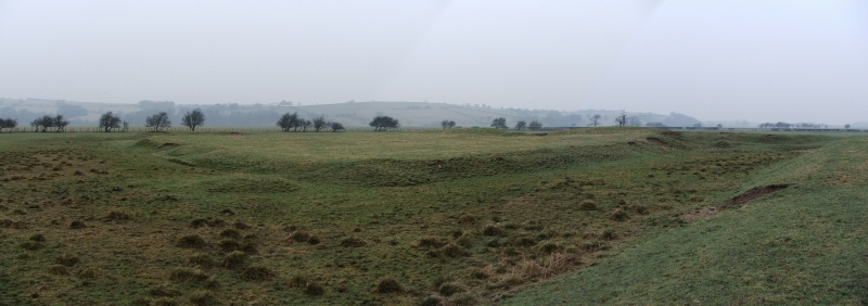
The site comprises a main moated site consisting of a rectangular island
surrounded by a flat-bottomed marshy moat which in turn is surrounded by
an outer shallow channel. A hollow way runs from the northeast corner of
the main moat to the main road 300m to the east. Some 90m north of the
northwest corner of the island is a moated outwork consisting of a small
island surrounded by a shallow moat. This outwork is connected by a
short length of ditch to a system of channels linking the main moated
site with a channel of the River Lune 350m to the northeast.
Moated sites are generally seen as the prestigious residences of the
Lords of the manor. The moat in such circumstances marked the high
status of the occupier, but also served to deter casual raiders and wild
animals. Most moats were constructed between 1250-1350.
The main moat is well defined, predominantly dry but containing some
marshy areas. Masonry foundations occupy part of the island and
earthworks project into or are located within the moat. Outer banks are
found on all sides. The moated outwork and connecting channels are dry
as is the outer shallow channel. The sum of the evidence suggest that
this monument is an unusual example of its type.
The fence to the east of the main moated site is not included in the
scheduling, neither is a drainage trench and drain aligned NW-SE that
crosses the monument close to its W corner, or a second drainage trench
and drain running below the moated outwork's NW arm. The ground beneath
the fence, drainage trenches and drains, however, is included.
MAP EXTRACT
The site of the monument is shown on the attached map extract.
Source: Historic England
Around 6000 moated sites are known in England. They consist of wide
ditches, often seasonally waterfilled, which partly or completely
enclosed one or more islands of dry ground on which stood domestic or
ecclesiastical buildings or which, in some cases, were used for
horticulture. The peak period during which moated sites were built was
between 1250-1350 and by far the greatest concentration lies in central
and eastern parts of England. Moated sites were built throughout the
Medieval period, however, are widely scattered across England and
exhibit a high level of diversity in their forms and sizes. They form a
significant class of Medieval monument and play an important part in
understanding the distribution of wealth and status in the countryside.
Many examples provide conditions favourable to the survival of normally-
perishable organic remains.
Camp House moated site, moated outwork and connecting channels survives
well, the earthworks being particularly evident. The monument displays a
diversity of components which include two moated sites, one of very
small size, interconnected by channels for water management. Both moated
sites and channels survive relatively undisturbed and possess
considerable potential for the recovery of archaeological details of
their original form and constructional remains. The channels linking the
two sites will also preserve details of the original inter-relationship
of the two moated sites.
Source: Historic England
Other
Darvill, T., MPP Single Monument Class Description - Moats, (1988)
Date : 7-4-1990, Mr Goth (site excavator), Contrebis (forthcoming), (1990)
Lancs SMR, PRN 556 AP.N-674,
Source: Historic England
Other nearby scheduled monuments