Approximate Location Map
Large Map »
This site is entirely user-supported. See how you can help.
Latitude: 51.3573 / 51°21'26"N
Longitude: -1.083 / 1°4'58"W
OS Eastings: 463946.326052
OS Northings: 162422.949633
OS Grid: SU639624
Mapcode National: GBR B5B.WHW
Mapcode Global: VHCZW.54TV
Entry Name: The Late Iron Age oppidum and Roman town of Calleva Atrebatum and associated features
Scheduled Date: 21 March 1923
Last Amended: 30 August 1995
Source: Historic England
Source ID: 1011957
English Heritage Legacy ID: 24336
County: Hampshire
Civil Parish: Silchester
Traditional County: Hampshire
Lieutenancy Area (Ceremonial County): Hampshire
Church of England Parish: Silchester St Mary
Church of England Diocese: Winchester
The monument includes the Late Iron Age oppidum and Roman town of Calleva
Atrebatum and associated earthworks which together extend over an area of
c.129ha. The town lies north east of the modern village of Silchester, in open
countryside at the eastern end of a gravel spur. The town was enclosed by a
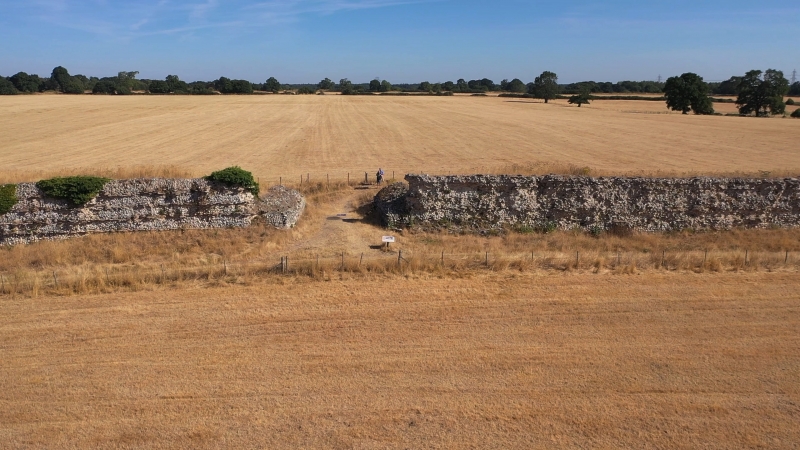
series of defensive circuits, of which the third century AD wall is the most
complete and well-preserved, marking periods of growth and retrenchment.
Extensive excavation within the walled area in the late 19th and early 20th
centuries by the Society of Antiquaries enabled a plan of much of the third
and fourth century AD town to be compiled but its earlier form and history
and those of the associated earthworks are less certain, although more recent
excavations have increased knowledge of both. In addition to the town wall and
earthwork defences, the amphitheatre is upstanding. Roads, building
foundations and other features are preserved below ground but are not now
visible, except as crop marks from the air.
Calleva is thought to have originated as an oppidum, a nucleated settlement,
in the Late Iron Age. The Atrebates, after whom the town was named, came to
southern Britain from Gaul and it is thought that their leader, Commius,
probably made the town his base after dispute with and flight from Julius
Caesar in about 50BC, joining some of his people who had earlier settled in
Britain. Recent excavations on the site of the later Roman basilica, near the
centre of the town, have indicated two main phases of pre-Roman occupation,
the earliest dating from the mid-first century BC, when wooden round houses
were constructed. Towards the end of the first century BC, the round houses
were replaced by a more formal, rectilinear arrangement of streets, plots and
timber buildings. Coins of Eppillus, a successor to Commius, bearing the mark
CALLE or CALLEV were most probably minted at Calleva, and other finds,
including amphorae and fine pottery, show that trade with the continent was
taking place in this period. The Iron Age settlement was protected by outlying
earthworks to the west and south, some of which are the subject of separate
schedulings, and by a closer, irregular western arc of banks and ditches,
represented by earthworks west of Rye House and in Rampier Copse; the latter,
known as the outer earthwork, is probably of slightly later date since one of
the earthworks appears to be truncated by the banks and ditch in Rampier
Copse. It has been suggested that a second defensive earthwork circuit, the
Inner Earthwork, may date from the period immediately before the Roman
invasion. This, however, appears to have been largely levelled during the
early stages of construction of the Roman town; its course is known from
crop marks and excavation and is also marked by subsidence of the later town
walls where they cross the infilled ditch.
Soil accumulation above one Late Iron Age street suggests that Calleva was
briefly abandoned before Roman rebuilding started in the second half of the
first century AD, while a short period of military occupation may also have
preceded the construction of the new town.
As a Roman town, Calleva was a civitas capital by the end of the first century
AD, a regional administrative centre for the Atrebates, reflecting its earlier
status and continuing importance in the government of the new province. The
town was laid out on a newly orientated street grid in the mid-first century
AD, although some buildings, including the bath house, reflect an earlier
street plan, perhaps that of the Iron Age settlement.
The forum and basilica were the focus of the Roman town, occupying a large,
central site. The forum provided an open space for public meetings and
markets, with shops and offices in the buildings enclosing it on three sides
and the basilica on the fourth, west, side. The basilica contained the council
chamber, court and administrative offices of the town and surrounding civitas.
The basilica went through at least two phases of timber construction, a
sequence which would have been followed throughout much of the town, before
being rebuilt in stone in the middle of the second century AD. The basilica
appears to have ceased to function as an official building during the third
century AD, when metal-working took place on the site. An enigmatic, fourth-
century AD building near the south east corner of the forum has been
interpreted as a possible Christian church, which if so would be one of
the earliest such buildings in Britain. It may, however, have been associated
with another religion altogether, and has also been suggested as a replacement
for the basilica as a site for council and judicial meetings.
Other public buildings included the baths in the south eastern part of the
town and a probable large mansio, or inn for travellers on official business,
near the south gate. The baths were sited beside a spring-fed stream
but the water supply may have been augmented by water piped from further
afield; the shallow gravel at Calleva caps water-bearing clay and wells were
sunk throughout the town. The mansio, after the forum and basilicam, Calleva's
second largest building, had a bath house and granary in addition to two wings
of possible self-contained suites of accommodation linked by a third wing
with a number of heated rooms. Several Romano-Celtic temples and shrines were
built in the town. At least two were by the east gate and it has been
suggested that a third may lie beneath the similarly aligned parish church.
The first century AD amphitheatre, which has been partly excavated, was built
beyond the wall at the north east corner of the town.
The remaining buildings ranged from small, undivided, rectangular structures
to larger, sub-divided buildings with one or more wings abutting or enclosing
courtyards. On stone foundations, the upper parts of many of these buildings
may have been of stone or timber-framed construction, no more than a single
storey high. The buildings would have provided shops, offices and
workshops as well as living accommodation for the town's inhabitants.
A defensive circuit of rampart and double ditches was constructed towards the
end of the second century AD. This was remodelled and strengthened by the
addition of a wall to the front of the rampart in the third century AD.
Crop-marks and excavation have shown that the street grid extended beyond the
area enclosed by the town defences as far as the earlier Outer Earthwork to
the west. A short-lived additional western earthwork was also constructed,
probably in the earlier period of the town's history, which may have been
intended to enclose a cemetery. The street grid did not extend into this area,
which was, however, crossed by the Cirencester road and another track
diverging from it. Crop marks suggest that buildings and plots flanked both
the Cirencester and London roads with, at the west, fields beyond them.
Adult burial was not permitted within towns and cemeteries had therefore to be
located outside the walls. The location and size of the Calleva cemeteries are
not certainly known, but four possible sites, including one in the western
extension described above, have been suggested by the discovery of small
clusters of cremations; the other sites are in the bank in Rampier Copse, to
the east of Church Lane nearby, and near the London road by the east gate. The
site of an inhumation cemetery is indicated by the discovery of a stone coffin
near the north gate.
The end of Roman Calleva is obscure. A few isolated finds, including a Roman
column reused as a tombstone and inscribed in Celtic ogham script, suggest
that the town was occupied until about the fifth century AD but thereafter it
appears to have been largely deserted. The threat represented by early Saxon
settlements not far to the north, at Dorchester on Thames, and to the south,
at Winchester, may have led to the town's abandonment. An attempt at
preventing encroachment from the north is suggested by the construction of
Grim's Bank, a linear earthwork running along the higher ground between
Calleva and the River Kennet from the Cirencester road towards and across the
line of the Dorchester road. The ability to construct such an earthwork does
indicate that a sizable community remained for a time in the neighbourhood, if
not in the town. No evidence of destruction has been found and the town's
decay may have been as a result of the gradual loss of surrounding territory
and the support it provided rather than through any more direct cause.
Silchester is mentioned in the Domesday book but the earliest surviving
building of the post-Roman village is the 12th and 13th century Church of St
Mary, near the east gate of the Roman town. Evidence of a mid 12th century
timber building was found during excavation within the Roman amphitheatre,
together with indication of a palisade on the top of the bank, suggesting that
the site was reused as a defensive stronghold. The north western corner of
Silchester deer park, probably enclosed in the 13th century, lies within the
town's eastern limits but the greater part of the park lies further to the
east. The focus of the village, however, moved westward to its present site on
Silchester Common, leaving the Roman town to revert to open country.
All modern houses, garages, sheds, loose boxes, barns, stores, greenhouses and
associated structures and areas of hard-standing, drives, paths and tennis
courts; all roads, metalled and unmetalled tracks, footpaths and car-parking
areas; all fences, gates, stiles, steps, signs and associated posts and
telegraph posts; all ponds, water tanks, troughs and associated pipes are
excluded from the monument, but the gound beneath them is included. St Mary's
Church, churchyard and the ground beneath them are also excluded from the
scheduling.
MAP EXTRACT
The site of the monument is shown on the attached map extract.
Source: Historic England
Five types of town are known to have existed in Roman Britain: coloniae,
municipia, civitas capitals, Roman provincial capitals and Roman small towns.
The first four types can be classified as `public towns' because each had an
official status within the provincial administrative system.
Civitas capitals are towns which functioned as the principal centres of the
civitatae or regions of Roman Britain. They were official creations, generally
established in the later first and early second centuries AD in newly pacified
areas where the process of Romanisation had been successfully inaugurated.
They were often established on the sites of earlier tribal centres or
settlements and were populated largely by native Britons rather than Roman
citizens.
Civitas capitals functioned as economic, cultural and administrative centres
for their respective regions. In terms of civic administration, a civitas
capital would either have had magistrates and a council or it may have been
administered directly for a time through officials known as "praefecti
civitatis".
Defensive walls usually defined the areas of civitas capitals, these ranging
in size from c.14ha to c.58ha. Within the walled area the main features
included: the forum-basilica, other major public buildings, private houses,
shops and workshops, piped water and sewage systems, a planned rectangular
street grid and, in some cases, waterfront installations. Beyond the walls, an
area of extra-mural settlement overspill can often be identified. This area
can be extensive and may include such features as an amphitheatre, quarries,
cemeteries, temples, rubbish dumps, commemorative monuments, potteries and
roads.
Thirteen civitas capitals are known in England, showing a relatively even
distribution throughout the so-called lowland zone of Roman Britain in the
more southerly and easterly parts of the country. They were set up in the wake
of the advancing army as it moved progressively north and westwards and it was
in the south and east that Romanisation had the earliest and most successful
impact.
The Late Iron Age oppidum and Roman town of Calleva Atrebatum, Silchester, is
in open country and therefore one of the small number of Roman towns where
subsequent building has not obscured the origins and development of the site.
Although none of the buildings within the town wall survive above ground
level, their stone-built foundations, as well as roads and other features are
known from partial excavation to survive below ground. The circuit of the
upstanding town wall provides an impressive visual feature, while beyond the
walls stand the amphitheatre and sections of the outer and outlying
earthworks.
Source: Historic England
Books and journals
Cunliffe, B, Iron Age communities in Britain, (1974), 69
Cunliffe, B, Wessex to AD1000, (1993), 241
Cunliffe, B, Wessex to AD1000, (1993), 287
Cunliffe, B, Wessex to AD1000, (1993), 206
De la Bedoyere, G, Roman Towns, (1992), 69-70
Fulford, M, Calleva Atrebatum: A guide to the Roman town at Silchester, (1987), 23
Fulford, M, Calleva Atrebatum: A guide to the Roman town at Silchester, (1987), 26
Fulford, M, Calleva Atrebatum: A guide to the Roman town at Silchester, (1987), 21
Fulford, M, Calleva Atrebatum: A guide to the Roman town at Silchester, (1987), 29
Fulford, M, Calleva Atrebatum: A guide to the Roman town at Silchester, (1987), 14-6
Fulford, M, Calleva Atrebatum: A guide to the Roman town at Silchester, (1987), 5
Fulford, M, Calleva Atrebatum: A guide to the Roman town at Silchester, (1987), 8-9
Fulford, M, Calleva Atrebatum: A guide to the Roman town at Silchester, (1987), 20
Fulford, M, Calleva Atrebatum: A guide to the Roman town at Silchester, (1987), 24-6
Fulford, M, Calleva Atrebatum: A guide to the Roman town at Silchester, (1987), 12
Wacher, J, The Towns of Roman Britain, (1974), 268
Wacher, J, The Towns of Roman Britain, (1974), 256-7
Boon, G C, 'Archaeologia' in Belgian and Roman Silchester: the excavations of 1954-8, , Vol. CII, (1969), 39
Boon, G C, 'Archaeologia' in Belgian and Roman Silchester: the excavations of 1954-8, , Vol. CII, (1969), 3
Boon, G C, 'Archaeologia' in Belgian and Roman Silchester: the excavations of 1954-8, , Vol. CII, (1969), 18-9
Boon, G C, 'Archaeologia' in Belgian and Roman Silchester: the excavations of 1954-8, , Vol. CII, (1969), 4
Boon, G C, 'Archaeologia' in Belgian and Roman Silchester: the excavations of 1954-8, , Vol. CII, (1969), 21
Boon, G C, 'Archaeologia' in Belgian and Roman Silchester: the excavations of 1954-8, , Vol. CII, (1969), 20
Boon, G C, 'Archaeologia' in Belgian and Roman Silchester: the excavations of 1954-8, , Vol. CII, (1969), 5-6
Boon, G C, 'Archaeologia' in Belgian and Roman Silchester: the excavations of 1954-8, , Vol. CII, (1969), IX
Fulford, M, 'Proc Prehist Soc' in Calleva Atrebatum: interim report on the oppidum excavation, (1987), 271
Fulford, M, 'Proc Prehist Soc' in Calleva Atrebatum: interim report on the oppidum excavation, (1987), 272-5
Fulford, M, 'Proc Prehist Soc' in Interim Report on the Excavation of the Oppidum 1980-86, (1987), 277
Fulford, M, 'Proc Prehist Soc' in Interim Report on the Excavation of the Oppidum 1980-86, (1987), 275
Fulford, M, 'Antiq J' in Interim Report on the Amphitheatre and Forum-Basilica Excavation, , Vol. LXV,I, (1985), 65
Fulford, M, 'Antiq J' in Interim Report on the Amphitheatre and Forum-Basilica Excavation, , Vol. LXV,I, (1985), 75
Fulford, M, 'Antiq J' in Interim Report on the Amphitheatre and Forum-Basilica Excavation, , Vol. LXV,I, (1985), 59
Fulford, M, 'Antiq J' in Interim Report on the Amphitheatre and Forum-Basilica Excavation, , Vol. LXV,I, (1985), 61
Fulford, M, 'Antiq J' in Interim Report on the Amphitheatre and Forum-Basilica Excavation, , Vol. LXV,I, (1985), 66
Fulford, M, 'Antiq J' in Interim Report on the Amphitheatre and Forum-Basilica Excavation, , Vol. LXV,I, (1985), 73-4
Fulford, M, 'Antiq J' in Interim Report on the Amphitheatre and Forum-Basilica Excavation, , Vol. LXV,I, (1985), 77
Fulford, M, 'Antiq J' in Interim Report on the Amphitheatre and Forum-Basilica Excavation, , Vol. LXV,I, (1985), 63
Fulford, M, 'Antiq J' in Interim Report on the Amphitheatre and Forum-Basilica Excavation, , Vol. LXV,I, (1985), 69
Fulford, M, Corney, M, 'Britannia Monograph Series' in Silchester Defences 1974-80, , Vol. 5, (1985), 269
Fulford, M, Corney, M, 'Britannia Monograph Series' in Silchester Defences 1974-80, , Vol. 5, (1985), 288
Fulford, M, Corney, M, 'Britannia Monograph Series' in Silchester Defences 1974-80, , Vol. 5, (1985), 82
Fulford, M, Corney, M, 'Britannia Monograph Series' in Silchester Defences 1974-80, , Vol. 5, (1985), 83
Fulford, M, Corney, M, 'Britannia Monograph Series' in Silchester Defences 1974-80, , Vol. 5, (1985), 81
Fulford, M, Corney, M, 'Britannia Monograph Series' in Silchester Defences 1974-80, , Vol. 5, (1985), 266-8
Fulford, M, Corney, M, 'Britannia Monograph Series' in Silchester Defences 1974-80, , Vol. 5, (1985), 79-80
Fulford, M, Corney, M, 'Britannia Monograph Series' in Silchester Defences 1974-80, , Vol. 5, (1985), 293-7
Fulford, M, Corney, M, 'Britannia Monograph Series' in Silchester Defences 1974-80, , Vol. 5, (1985), 263
Fulford, M, Corney, M, 'Britannia Monograph Series' in Silchester Defences 1974-80, , Vol. 5, (1985), 293-7
Fulford, M, Corney, M, 'Britannia Monograph Series' in Silchester Defences 1974-80, , Vol. 5, (1985), 79
Fulford, M, Corney, M, 'Britannia Monograph Series' in Silchester Defences 1974-80, , Vol. 5, (1985), 253-7
Fulford, M, Corney, M, 'Britannia Monograph Series' in Silchester Defences 1974-80, , Vol. 5, (1985), 235-7
Fulford, M, Corney, M, 'Britannia Monograph Series' in Silchester Defences 1974-80, , Vol. 5, (1985), 276-7
Other
HCC, SU 66SE 2, (1986)
HCC, SU 66SW 58, (1986)
Source: Historic England
Other nearby scheduled monuments