Approximate Location Map
Large Map »
This site is entirely user-supported. See how you can help.
Latitude: 53.3405 / 53°20'25"N
Longitude: -1.7773 / 1°46'38"W
OS Eastings: 414923.275874
OS Northings: 382647.345243
OS Grid: SK149826
Mapcode National: GBR JY1T.07
Mapcode Global: WHCCL.N9VF
Entry Name: Peveril Castle eleventh to fourteenth century tower keep castle
Scheduled Date: 9 October 1981
Last Amended: 6 April 1992
Source: Historic England
Source ID: 1010829
English Heritage Legacy ID: 13268
County: Derbyshire
Civil Parish: Castleton
Built-Up Area: Castleton
Traditional County: Derbyshire
Lieutenancy Area (Ceremonial County): Derbyshire
Church of England Parish: Castleton St Edmund
Church of England Diocese: Derby
Peveril Castle is a tower keep castle situated above the north bank of Cave
Dale to the south of Castleton. The monument comprises two constraint areas,
divided by a narrow ravine, the first incorporating the standing remains of
the castle along with the terraced hillside leading to the north-east gate,
and the second containing the site of the outer bailey and access to the main
south-west gate.
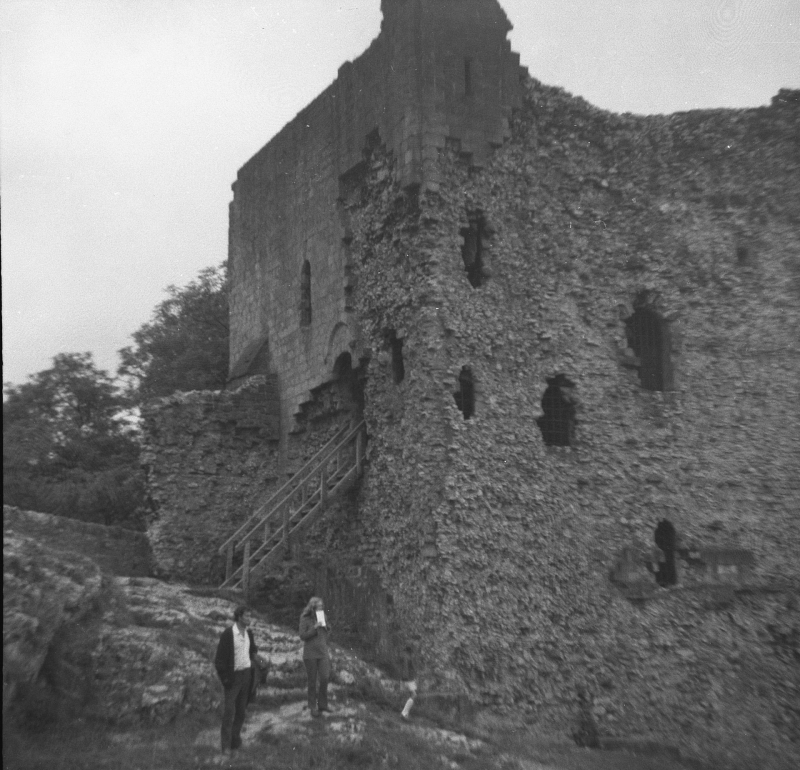
The standing remains of the monument consist primarily of the square keep and
a curtain wall enclosing a roughly triangular inner bailey measuring c.100m x
60m. The north wall, although much repaired and altered, still contains
eleventh century sections, though the remainder of the curtain is twelfth
century. The keep, which stands almost to its original height and is also
twelfth century, was originally entered at the first floor. It was a
primarily defensive feature and, as the castle had fallen into disuse by the
fifteenth century, was not adapted to domestic use. It therefore remained a
simple structure with only one floor above the entrance level and a basement
floor below. Its main function was to guard the south-west gate into the
inner bailey. This was reached from the outer bailey via a bridge which,
during the Middle Ages, spanned the intervening gorge. A masonry abutment for
the bridge can be seen in the ditch below the keep.
The outer bailey lies to the south-west where a bank and ditch forms the
western boundary of a triangular enclosure, measuring c.80m x 60m, where
cattle, horses and people would have been housed. The bank contains the
remains of a defensive wall and a gap approximately midway along it shows
where the `Earl's road' entered the castle from the south-west at its
main point of access.
The steep path up the hillside from the north, which entered the inner bailey
via the north-east gate, was a consequence of the town's foundation in the
late twelfth century and was largely for pedestrian use, being too steep for
vehicles. The castle itself was founded in 1086 and remained in the hands of
the Peverel family until 1155 when it was taken over by the Crown. It was
granted to John of Gaunt by Edward III in the fourteenth century, thus
becoming part of the Duchy of Lancaster, and remained in use until some time
after 1400. The standing remains and the northern approach have been in State
care since 1932 and the standing remains are a Grade I Listed Building. There
are a number of features which are excluded from the scheduling. These are
the sales office, the surface of the modern path leading to the inner bailey
and all English Heritage fixtures such as railings, safety grilles and
notices.
The ground beneath all these features is included in the scheduling.
MAP EXTRACT
The site of the monument is shown on the attached map extract.
Source: Historic England
A tower keep castle is a strongly fortified residence in which the keep is the
principal defensive feature. The keep may be free-standing or surrounded by a
defensive enclosure; they are normally square in shape, although other shapes
are known. Internally they have several floors providing accommodation of
various types. If the keep has an attached enclosure this will normally be
defined by a defensive wall, frequently with an external ditch. Access into
the enclosure was provided by a bridge across the ditch, allowing entry via a
gatehouse. Additional buildings, including stabling for animals and workshops,
may be found within the enclosure. Tower keep castles were built throughout
the medieval period, from immediately after the Norman Conquest to the mid-
15th century, with a peak in the middle of the 12th century. A few were
constructed on the sites of earlier earthwork castle types but most were new
creations. They provided strongly fortified residences for the king or leading
families and occur in both urban or rural situations. Tower keep castles are
widely dispersed throughout England with a major concentration on the Welsh
border. They are rare nationally with only 104 recorded examples. Considerable
diversity of form is exhibited with no two examples being exactly alike. With
other castle types, they are major medieval monument types which, belonging to
the highest levels of society, frequently acted as major administrative
centres and formed the foci for developing settlement patterns. Castles
generally provide an emotive and evocative link to the past and can provide a
valuable educational resource, both with respect to medieval warfare and
defence, and to wider aspects of medieval society. All examples retaining
significant remains of medieval date are considered to be nationally
important.
Peveril Castle is an important and well-documented example of a tower keep
castle and is one of a very small number nationally to be built of stone
immediately after the Conquest. As a result, substantial sections of eleventh
century masonry survive. In addition, considerable archaeological deposits
survive both in the inner bailey and along the approach from the north, and
also, in particular, in the outer bailey which has never been excavated.
Source: Historic England
Books and journals
Colvin, H M, The History of the King's Works, (1963), 776
Hart, CR, North Derbyshire Archaeological Survey, (1984), 148
O'Neil, BH St J, Peveril Castle, (1950)
White, P R, Peveril Castle, (1979)
Source: Historic England
Other nearby scheduled monuments