Approximate Location Map
Large Map »
This site is entirely user-supported. See how you can help.
Latitude: 54.3628 / 54°21'46"N
Longitude: -1.1636 / 1°9'49"W
OS Eastings: 454442.634247
OS Northings: 496685.389897
OS Grid: SE544966
Mapcode National: GBR NK9Z.WT
Mapcode Global: WHD80.3L4S
Entry Name: Two round barrows at Joseph Wade's Hut
Scheduled Date: 16 September 1994
Source: Historic England
Source ID: 1010808
English Heritage Legacy ID: 25520
County: North Yorkshire
Civil Parish: Bilsdale Midcable
Traditional County: Yorkshire
Lieutenancy Area (Ceremonial County): North Yorkshire
Church of England Parish: Upper Ryedale
Church of England Diocese: York
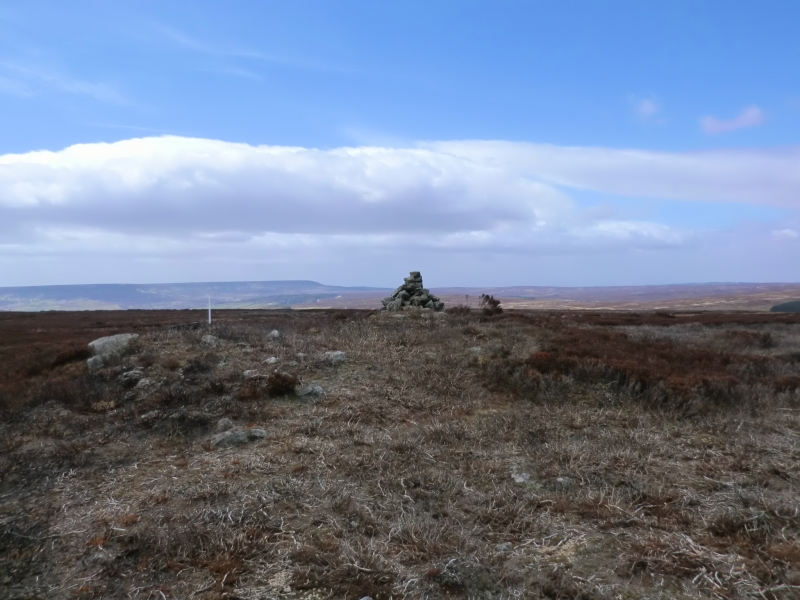
The monument includes two adjacent round barrows which, together, are
orientated north west-south east, situated in a prominent position on the east
edge of Bilsdale West Moor overlooking Ryedale. The northern barrow has an
earth and stone mound standing 0.6m high. It is round in shape and is 7m in
diameter. There is a clearly defined kerb around the mound.
The southern barrow has a large well defined mound standing 1.2m high. It is
round in shape and is 15m in diameter. The remains of a modern stone structure
stands on the mound. Both these mounds were each encircled by a ditch up to
3m wide which has become filled in over the years and is no longer visible
as an earthwork.
This monument is one of many similar examples on this area of the Hambleton
Hills. Many of these lie in closely associated groups, particulary along the
watersheds. They provide evidence of territorial organisation marking
divisions of land, divisions which still remain as some parish or township
boundaries.
MAP EXTRACT
The site of the monument is shown on the attached map extract.
It includes a 2 metre boundary around the archaeological features,
considered to be essential for the monument's support and preservation.
Source: Historic England
Bowl barrows, the most numerous form of round barrow, are funerary monuments
dating from the Late Neolithic period to the Late Bronze Age, with most
examples belonging to the period 2400-1500 BC. They were constructed as
earthen or rubble mounds, sometimes ditched, which covered single or multiple
burials. They occur either in isolation or grouped as cemeteries and often
acted as a focus for burials in later periods. Often superficially similar,
although differing widely in size, they exhibit regional variations in form
and a diversity of burial practices. There are over 10,000 surviving bowl
barrows recorded nationally (many more have already been destroyed), occurring
across most of lowland Britain. Often occupying prominent locations, they are
a major historic element in the modern landscape and their considerable
variation of form and longevity as a monument type provide important
information on the diversity of beliefs and social organisations amongst early
prehistoric communities. They are particularly representative of their period
and a substantial proportion of surviving examples are considered worthy of
protection.
Despite limited disturbance both these barrows have survived well.
Significant information about the original form, burials placed within them
and evidence of earlier land use beneath the mounds will be preserved.
They are part of a group of barrows clustered on this part of the Hambleton
Hills thought to mark a prehistoric boundary. Similar groups of monuments are
also known across the north and central areas of the North York Moors
providing important insight into burial practice. Such groupings of monuments
offer important scope for the study of the division of land for social, ritual
and agricultural purposes in different geographical areas during the
prehistoric period.
Source: Historic England
Books and journals
Spratt, D A , 'Prehistoric and Roman Archaeology in North East Yorkshire' in Prehistoric and Roman Archaeology of North East Yorkshire, (1993)
Spratt, D A , 'Prehistoric and Roman Archaeology in North East Yorkshire' in Prehistoric and Roman Archaeology of North East Yorkshire, (1993)
Source: Historic England
Other nearby scheduled monuments