Approximate Location Map
Large Map »
This site is entirely user-supported. See how you can help.
Latitude: 54.3063 / 54°18'22"N
Longitude: -1.229 / 1°13'44"W
OS Eastings: 450261.6685
OS Northings: 490347.7846
OS Grid: SE502903
Mapcode National: GBR MLVN.Q2
Mapcode Global: WHD8C.3102
Entry Name: Section of the Cleave Dyke system on Arden Little Moor known as Steeple Cross Dyke including the Steeple Cross boundary stone
Scheduled Date: 4 May 1995
Source: Historic England
Source ID: 1010533
English Heritage Legacy ID: 25597
County: North Yorkshire
Civil Parish: Boltby
Traditional County: Yorkshire
Lieutenancy Area (Ceremonial County): North Yorkshire
Church of England Parish: Upper Ryedale
Church of England Diocese: York
The monument includes a section of the prehistoric linear boundary system on
the Hambleton Hills, known as the Cleave Dyke.
The monument extends for 1550m westwards from the head of Stony Gill Hole
terminating at a valley head cutting the scarp face near Steeple Cross. Beyond
this point to the west the dyke has been levelled by forestry activity
although it would originally have continued to meet the line of another dyke
in the system. The monument is a prominent linear earthwork comprising a ditch
which lies between two banks. The ditch is 3.5m wide and 0.9m deep whilst the
northern bank is 3.5m wide and 0.5m high and the southern one 2.5m wide 0.3m
high. Near the Steeple Cross the bank has been levelled by the Hambleton Road
but remains of the bank and the ditch will remain preserved as a buried
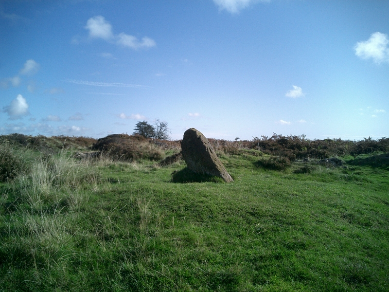
feature beneath the road. The Steeple Cross comprises a short section of cross
shaft standing in the ground. It has been significantly eroded and has an
irregular profile. It is c.0.45m by 0.5m square, standing 0.7m proud of the
ground.
This dyke is part of a wider system of earthworks continuing for 9km north-
south along the western edge of the Hambleton Hills. Shorter east-west
boundaries linked valley heads to the main dyke and thus divided the terrain
into discrete units for agricultural and social purposes. The dyke is
associated with earlier round barrows which also marked the division of land.
Together the monuments on this part of the Hambleton Hills provide important
evidence of territorial organisation and the development of settled
agricultural practices.
The wall along the side of the monument and grouse butts are excluded from the
scheduling although the ground beneath these features is included.
MAP EXTRACT
The site of the monument is shown on the attached map extract.
It includes a 2 metre boundary around the archaeological features,
considered to be essential for the monument's support and preservation.
Source: Historic England
The Cleave Dyke System is the most westerly of a series of dyke systems on the
Tabular Hills of north east Yorkshire. The name has been given to a series of
linear ditches and banks stretching north-south over 9km parallel with and
close to the western scarp of the Hambleton Hills. The system was constructed
between the Late Bronze Age and the Iron Age to augment the natural division
of the terrain by river valleys and watersheds. Significant stretches remain
visible as upstanding earthworks; elsewhere it can be recognised as a cropmark
on aerial photographs. The system formed a prehistoric territorial boundary in
an area largely given over to pastoralism; the impressive scale of the
earthworks displays the corporate prestige of their builders. In some
instances the boundaries have remained in use to the present day. Linear
boundaries are of considerable importance for the analysis of settlement and
land use in the later prehistoric period; all well preserved examples will
normally merit statutory protection.
This section of the Cleave Dyke system is preserved as a prominent earthwork
for most of its length, forming a very clear division across the landscape.
Significant remains are preserved which will retain important information
about the date and function of the monument, and thereby contribute towards
the study of the division of land for social, ritual and agricultural purposes
in this area during the prehistoric period.
The Steeple Cross is one of a group of medieval crosses on the North Yorkshire
Moors. In addition to serving the function reiterating and reinforcing the
Christian faith amongst those who passed the cross and of reassuring the
traveller, crosses were also erected to mark property boundaries or to serve
as places for public proclamation and penance. Such crosses contribute to our
understanding of medieval religious customs. All well presrved examples, and
especially those which stand in or near their original location, are
considered worthy of protection.
Source: Historic England
Books and journals
Graham, L, M, , 'The Crosses of the North York Moors' in The Crosses of the North York Moors, (1993), 15
Other
Pacitto 30/1:2,
Source: Historic England
Other nearby scheduled monuments