Approximate Location Map
Large Map »
This site is entirely user-supported. See how you can help.
Latitude: 54.423 / 54°25'22"N
Longitude: -2.9678 / 2°58'4"W
OS Eastings: 337302.325547
OS Northings: 503493.652052
OS Grid: NY373034
Mapcode National: GBR 7KQ9.87
Mapcode Global: WH82D.D302
Entry Name: Ambleside Roman fort, associated vicus and Roman road
Scheduled Date: 8 December 1938
Last Amended: 23 October 1992
Source: Historic England
Source ID: 1009348
English Heritage Legacy ID: 13567
County: Cumbria
Civil Parish: Lakes
Built-Up Area: Ambleside
Traditional County: Westmorland
Lieutenancy Area (Ceremonial County): Cumbria
Church of England Parish: Ambleside
Church of England Diocese: Carlisle
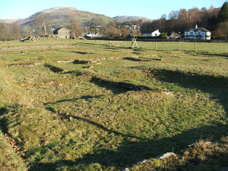
The monument includes Ambleside Roman fort, identified as the site of Galava
noted in classical sources, part of its associated civilian settlement or
vicus, and a length of Roman road approaching the fort's east gate. The fort
is located at the head of Lake Windermere in Borrans Field, a short distance
east of the River Brathay, and is visible as a raised platform approximately
1.3m high and covering some 1.54 hectares. It is flanked on much of the north
and east sides by two defensive ditches each surviving up to 7.5m wide and
0.3m deep. Foundations of the granary, headquarters building, commanding
officer's house, east and south gates, north-east and north-west angle towers,
and a short length of the fort wall have been left exposed following limited
excavations between 1914-20. An earlier smaller fort underlies much of the
platform but extended further to the east and north of the later fort and
incorporated a rocky knoll at its north-western corner. The fort is believed
to have accommodated a unit of infantry 500 strong. Ceramic evidence and
limited excavation suggests occupation commenced during the AD 90's with the
construction of a turf and timber fort. This was replaced by the larger stone
fort during the reign of Hadrian (AD 117-38) that was either abandoned or left
with a greatly reduced manpower under the next emperor, Antoninus Pius (AD
138-61) . The fort was then reoccupied during the reign of Marcus Aurelius
(AD 161-80) and remained garrisoned until at least the late 4th century. The
latest recorded coin is of Valens (died AD 378). The vicus extends to the
north and east of the fort. Its existence is confirmed by limited
excavations, aerial photographs and chance finds over a wide area. Roman
pottery was found in the field north of Galava Gate in 1875.
Limited excavations to the north of the fort in a flat area between rocky
knolls in 1920 located a road laid on a timber corduroy. To the east of this
road, in an area measuring some 60m north-south by 18m east-west, were floor
levels with charcoal and pottery of 2nd and 3rd century date. Cropmarks
photographed in 1955 in the field to the south of Ambleside Rugby Club show
features resembling a temporary Roman camp and the presence of buried
structures. Limited excavations and watching briefs during the 1980's and
early 1990's in the fields north of Galava Gate and east of the rugby club,
and beneath Borrans Road during widening operations and service trench
refurbishment, have located areas of industrial tipping, occupation floors, a
frequently repaired road surface up to 1m thick, cobbled areas, a slate floor
on timber rafting, and remains thought to be consistent with wattle and daub
buildings. This evidence has been taken to indicate that the main focus of
the vicus lay in this area, perhaps with buildings fronting onto the Roman
road which ran to the north-east of the fort. It should be noted that further
evidence of buildings were found a little to the south, outside the area of
the scheduling, during excavations in the early 1960's prior to the
construction of a new housing estate east of Borrans Road and north-east of
the fort. A substantial ditch 3-4m wide running east-west and situated at the
north-west corner of the field east of the rugby club, some 350m north of the
fort, has been interpreted as marking the northern limit of the vicus. To the
east of the fort the agger, or raised causeway, of a Roman road is clearly
visible for some 100m running from Borrans Road, through Borrans Park, and
entering the fort through its east gate. As a linear earthwork it measures up
to 10m wide and 0.3m high. A Roman tombstone found in the vicinity records
two names - one of those commemorated having been killed by enemy action
within the fort, and this evidence suggests a cemetery flanked the road, as
was common practice. Walling revealed in the lake side to the south-east of
the fort infers the presence of dock facilities. The view that the vicus
clustered around main access roads into the fort is supported by evidence from
the majority of other comparable sites, particularly those associated with the
northern frontier line. The extent of the vicus at Ambleside indicated by
these various finds demonstrates that while the origins of the settlement
probably began as a cluster of buildings grouped around an access road it must
have expanded considerably to occupy a much greater area.
Ambleside Roman fort and an area of the vicus extending north of the fort for
some 85m is in the guardianship of the Secretary of State. The fort is a
Listed Building Grade 1.
All buildings, field boundaries, walls, fences, gateposts, telegraph poles,
signposts, service pipes, roads, tracks, footpaths and access drives are
excluded from the scheduling, although the ground beneath all these features
is included.
MAP EXTRACT
The site of the monument is shown on the attached map extract.
Source: Historic England
Around 150 Roman forts are known to have existed in England of which 60 have
produced evidence of associated civilian settlements or vici. Sites like the
Ambleside example are thus rare nationally. Construction of these forts began
soon after the invasion of AD 43 and continued into the fourth century. The
distribution of these forts reflects areas where a military presence was
necessary, and the north of England, acting as a buffer between barbarian
tribes of northern Britain and the heavily Romanised southern half of the
country, contained a large number of these military bases. These sites
provide considerable insight into the complexities of the frequently changing
Roman frontier military strategy and add important detail to the historical
account of the Roman subjugation of Britain. Of particular importance at
Ambleside is the laying of an earthen platform on top of much of the early
fort in order to provide an elevated base above floodwater level on which to
construct the later stone fort. This platform will offer substantial
protection to the buried remains of much of the early fort. The whole of the
later fort and much of the vicus area is unencumbered by modern development.
Galava is located at the junction of Roman roads penetrating the Lake District
and would have been closely involved in the control and policing of the native
population of this mountainous area and the wider northern frontier region.
The attached vicus would have comprised a cluster of buildings - domestic
residences, workshops and shops located immediately adjacent to the fort.
Such vici were similar to contemporary small towns although they lacked the
public buildings and planned street grid normally evident in the latter.
Normally they also lacked the defences surrounding the small towns.
Unusually, however, the possibility that the vicus at this site was defended
does exist. Unlike other towns vici were probably administered by the
military authorities rather than being self-governing. The close
juxtaposition of fort and vicus allows the relationship between the military
and civilian communities to be investigated. In this instance the close
proximity of the site to the Hadrianic frontier region was probably of
considerable contemporary importance and activities in the vicus are thought
to have been closely linked with wider activity within the frontier region.
Limited excavation and other techniques employed here demonstrate the extent
of this site and confirm that archaeological deposits survive well and
extensively. The site therefore retains considerable information about its
origin and form.
Source: Historic England
Books and journals
Camden, W, Britannia, (1586)
Garlick, T, Ambleside Roman fort, (1975)
Lancaster University Archaeological Unit, , Proposed Course of the Rothay Relief Road, Ambleside. Arch.Eval., (1990)
West, FT, Journey through the Lake District, (1778)
Blake, B, 'Trans Cumb and West Antiq and Arch Soc. New Ser.' in Crop-Marks Near the Roman Fort at Ambleside, , Vol. LV, (1956)
Burkett, M, 'Trans Cumb and West Antiq and Arch Soc. New Ser.' in Recent Discoveries at Ambleside, , Vol. LXV, (1965)
Collingwood, R G, 'Trans Cumb & West Antiq & Arch Soc. New Ser.' in Explorations in the Roman Fort at Ambleside (4th year, 1920), , Vol. XXI, (1921)
Collingwood, R G, 'Trans Cumb and West Antiq and Arch Soc. New Ser' in Ambleside Roman Fort, (1914)
Other
DOE, List of Buildings of Historic & Architectural Interest,
DOE, List of Buildings of Historic & Architectural Interest,
Godbert, J (Site excavator), To Robinson, K.D., (1991)
Leech, RH & Scott, D, The Watching Brief in Advance of Road Construction, 1983, Pagination 1-13
Source: Historic England
Other nearby scheduled monuments