Approximate Location Map
Large Map »
This site is entirely user-supported. See how you can help.
Latitude: 53.3717 / 53°22'18"N
Longitude: -1.8855 / 1°53'7"W
OS Eastings: 407716.652321
OS Northings: 386099.291386
OS Grid: SK077860
Mapcode National: GBR HY8G.L1
Mapcode Global: WHCCC.0JF1
Entry Name: Wayside and boundary cross known as Edale Cross
Scheduled Date: 16 November 1934
Last Amended: 21 March 1994
Source: Historic England
Source ID: 1008615
English Heritage Legacy ID: 23342
County: Derbyshire
Civil Parish: Hayfield
Traditional County: Derbyshire
Lieutenancy Area (Ceremonial County): Derbyshire
Church of England Parish: Hayfield St Matthew
Church of England Diocese: Derby
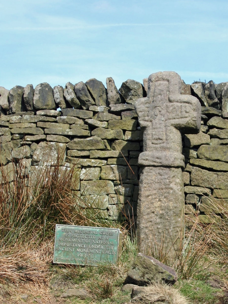
The monument, known both as Edale Cross and Champion Cross, is situated below
Kinderlow in the northern gritstone moorlands of the Derbyshire Peak District.
It includes a freestanding medieval wayside and boundary cross which stands on
the parish boundary between Hayfield and Edale next to the ancient moorland
track between the two villages. It also marked the edge of the former royal
forest of Peak Forest.
The cross comprises a dressed gritstone shaft of rectangular section
surmounted by an integral equal-armed cross head above a band-like collar. The
cross head is out of proportion with the shaft which suggests that the latter
is shorter than it was originally and that it may formerly have been set into
a socle or base stone. Currently the overall height is 1.6m while the shaft,
from ground to collar, is 85cm high and measures 34cm from east-west by 26cm
from north-south. It has chamfered edges and is wedged into the ground by
packing stones. The collar is 10cm wide and the cross head, which faces south
towards the track noted above, is 65cm high and would have been approximately
the same distance across but for damage done in the past to its west arm. Both
faces of the cross head are decorated with an incised inner cross which
contains, on the south side, the inscription HG 1610 and, on the north side,
four sets of initials: WD, EH, JH and JS. The end of the east arm of the cross
is also inscribed JH and it is assumed that all of these groups of letters are
later graffiti while the date and its associated letters may relate to a 17th
century survey. Excluded from the scheduling are the drystone walls enclosing
the cross on three sides and the plaque next to it, although the ground
beneath these features is included.
MAP EXTRACT
The site of the monument is shown on the attached map extract.
Source: Historic England
Wayside crosses are one of several types of Christian cross erected during the
medieval period, mostly from the 9th to 15th centuries AD. In addition to
serving the function of reiterating and reinforcing the Christian faith
amongst those who passed the cross and of reassuring the traveller, wayside
crosses often fulfilled a role as waymarkers, especially in difficult and
otherwise unmarked terrain. The crosses might be on regularly used routes
linking ordinary settlements or on routes having a more specifically religious
function, including those providing access to religious sites for parishioners
and funeral processions, or marking long-distance routes frequented on
pilgrimages.
Over 350 wayside crosses are known nationally, concentrated in south-west
England throughout Cornwall and on Dartmoor where they form the commonest type
of stone cross. A small group also occurs on the North York Moors. Relatively
few examples have been recorded elsewhere and these are generally confined to
remote moorland locations.
Outside Cornwall almost all wayside crosses take the form of a 'latin' cross,
in which the cross-head itself is shaped with the projecting arms of an
unenclosed cross. In Cornwall wayside crosses vary considerably in form and
decoration. The commonest type includes a round, or 'wheel', head on the faces
of which various forms of cross or related designs were carved in relief or
incised, the spaces between the cross arms possibly pierced. The design was
sometimes supplemented with a relief figure of Christ and the shaft might bear
decorative panels and motifs. Less common forms in Cornwall include the
'Latin' cross and, much rarer, the simple slab with a low relief cross on both
faces. Rare examples of wheel-head and slab-form crosses also occur within the
North York Moors group. Most wayside crosses have either a simple socketed
base or show no evidence for a separate base at all.
Wayside crosses contribute significantly to our understanding of medieval
religious customs and sculptural traditions and to our knowledge of medieval
routeways and settlement patterns. All wayside crosses which survive as earth-
fast monuments, except those which are extremely damaged and removed from
their original locations, are considered worthy of protection.
Edale Cross is a well-preserved example of a finely dressed wayside cross set
in its original location on an ancient route across open moorland. Of equal
importance is its role as a medieval boundary cross marking the edge of a
royal forest.
Source: Historic England
Books and journals
Firth, G B, Highways and Byways of Derbyshire212
Tudor, T L, The High Peak to Sherwood53
'Derbyshire Archaeological Journal' in Derbyshire Archaeological Journal, , Vol. 55, (1934), 77
Cox, Rev. J C, 'The Athenaeum' in The Athenaeum, , Vol. 4002, (1904), 57
Routh, T E, 'Derbyshire Archaeological Journal' in A Corpus Of Pre-Conquest Carved Stones In Derbyshire, , Vol. 58, (1937), 1-46
Source: Historic England
Other nearby scheduled monuments