Approximate Location Map
Large Map »
This site is entirely user-supported. See how you can help.
Latitude: 54.3379 / 54°20'16"N
Longitude: -1.1759 / 1°10'33"W
OS Eastings: 453676.029101
OS Northings: 493901.317087
OS Grid: SE536939
Mapcode National: GBR NL78.6R
Mapcode Global: WHD85.X76C
Entry Name: Cairnfield on the south west of Hawnby Moor including a round barrow and a standing stone
Scheduled Date: 8 February 1968
Last Amended: 5 September 1994
Source: Historic England
Source ID: 1008586
English Heritage Legacy ID: 25501
County: North Yorkshire
Civil Parish: Hawnby
Traditional County: Yorkshire
Lieutenancy Area (Ceremonial County): North Yorkshire
Church of England Parish: Upper Ryedale
Church of England Diocese: York
The monument includes a cairnfield extending over an area 670m by 140m on the
south west flank of Hawnby Moor. Also included is a round barrow and a
standing stone.
The cairnfield consists of 169 cairns spreading south west-north east for a
distance of 670m. Most of these are round in shape and range in diameter from
1.5m to 8m and in height from 0.2m to 1m. There are several cairns which are
elongated but no higher than 1m. There are also low banks of earth and stone,
some straight but others with curves in them. None of these banks exceed 25m
in length and they are all 3m wide and 0.3m high. The banks do not form any
overall pattern. They are interpreted as part of the field system indicated by
the clearance cairns.
In the north east of the monument is a round barrow. It has an earth and stone
mound standing 0.5m high. It is round in shape and 8m in diameter. The centre
of the mound has been dug into in the past. The mound was surrounded by a
ditch up to 3m wide which has become filled in over the years and is no longer
visible as an earthwork.
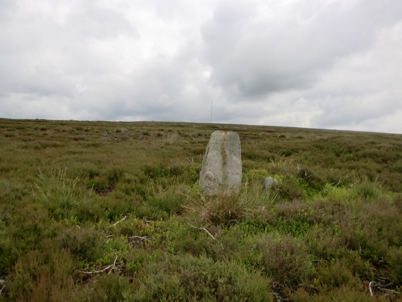
The standing stone is situated about 200m to the south west of the barrow. It
is a vertical slab 1m high, 0.9m wide and 0.3m thick which leans to the south
east. There are other similar monuments on this part of the Hambleton Hills
also associated with barrows. They provide evidence of agricultural practices
and the organisation of land in the prehistoric period.
The grouse butts at the south end of the monument are excluded from the
scheduling although the ground beneath is included.
MAP EXTRACT
The site of the monument is shown on the attached map extract.
Source: Historic England
Cairnfields are concentrations of cairns sited in close proximity to one
another. They often consist largely of clearance cairns, built with stone
cleared from the surrounding landsurface to improve its use for agriculture,
and on occasion their distribution pattern can be seen to define field plots.
However, funerary cairns are also frequently incorporated, although without
excavation it may be impossible to determine which cairns contain burials.
Clearance cairns were constructed from the Neolithic period (from c.3400 BC),
although the majority of examples appear to be the result of field clearance
which began during the earlier Bronze Age and continued into the later Bronze
Age (2000-700 BC). The considerable longevity and variation in the size,
content and associations of cairnfields provide important information on the
development of land use and agricultural practices. Cairnfields also retain
information on the diversity of beliefs and social organisation during the
prehistoric period.
This monument is well preserved and contains over 150 cairns, several lengths
of linear earthwork and a round barrow. It is part of a pattern of similar
monuments in this area which will contain significant information about the
development of agricultural and ritual practice and provide important insight
into the continuity of use in the prehistoric period.
Source: Historic England
Books and journals
Spratt, D A , 'Prehistoric and Roman Archaeology in North East Yorkshire' in Prehistoric and Roman Archaeology of North East Yorkshire, , Vol. BAR 104, (1993)
Other
Pacitto A, AM 107 NO.122 AA11635/1,
Pacitto A, Survey by FMW AM 107 record,
Pacitto A, Survey by FMW AM107 report,
Source: Historic England
Other nearby scheduled monuments