Approximate Location Map
Large Map »
This site is entirely user-supported. See how you can help.
Latitude: 54.5429 / 54°32'34"N
Longitude: -1.9255 / 1°55'31"W
OS Eastings: 404915.242178
OS Northings: 516404.734998
OS Grid: NZ049164
Mapcode National: GBR GHZX.X8
Mapcode Global: WHB4L.D2BP
Entry Name: Barnard Castle: ringwork, shell keep castle, chapel and dovecote
Scheduled Date: 13 January 1915
Last Amended: 5 December 1994
Source: Historic England
Source ID: 1007505
English Heritage Legacy ID: 23222
County: County Durham
Civil Parish: Barnard Castle
Built-Up Area: Barnard Castle
Traditional County: Durham
Lieutenancy Area (Ceremonial County): County Durham
Church of England Parish: Barnard Castle with Whorlton
Church of England Diocese: Durham
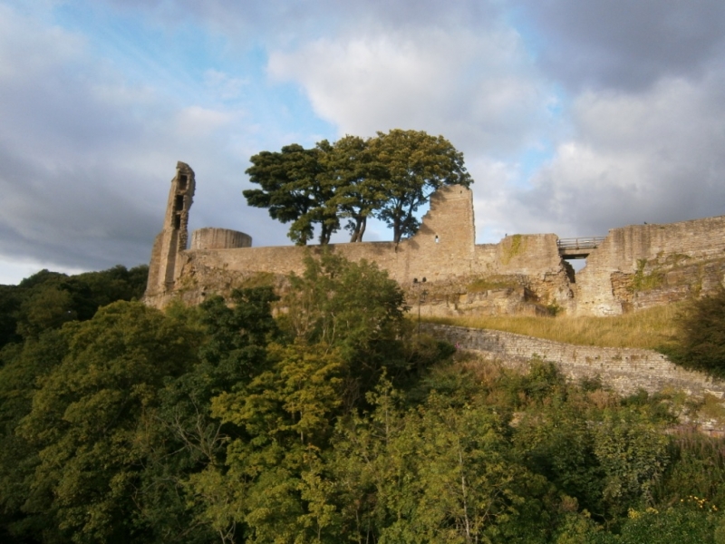
The monument is situated on a cliff above the River Tees and includes an early
12th century ringwork, a 12th to 14th century shell keep castle with four
wards or enclosures, a chapel and a dovecote. Formerly, an outer ditch
enclosed the east side of the castle between the curtain wall and the Horse
Market. Although the remains of this ditch will survive beneath later urban
development, it is not included in the scheduling as the extent of the remains
is not sufficiently understood. A series of partial excavations carried out
within the later castle walls between 1974 and 1982 has shown that the
earliest fortification dates to between c.1109 and 1125. It was constructed
overlooking the river where the cliff turned eastwards into the mouth of a
gully. A ditch was quarried in an arc from the north cliff to the west cliff,
enclosing a roughly circular area with a diameter of c.50m. The upcast from
the ditch was used to create a rampart along the inside of the ditch and this,
together with the cliff edge, was surmounted by a timber palisade. Within this
ringwork the remains of wooden outbuildings and a large timber hall have been
found beneath the floors of later stone buildings. Access to the interior was
via a bridge across the ditch which led through a timber gatehouse located at
the junction of the ditch with the west cliff. This gatehouse was soon
afterwards rebuilt in stone and was the earliest stone building of the castle.
The main period of reconstruction came in two phases between c.1125 and 1170.
During the first phase, 1125-1140, the ringwork was strengthened by the
excavation of the Great Ditch, a substantial rock-cut feature along the line
of the earlier ditch, and the palisade was replaced by a multi-angular curtain
wall with a wall walk and an interval tower along the east side. The original
entrance was blocked and a new entrance was built alongside it at the head of
a wooden bridge across the Great Ditch. The stone gatehouse became
incorporated into the larger Headlam Tower and a small rectangular keep was
built at the north east angle of the enclosure. In addition, the rampart was
widened to create a site for timber buildings along the inside of the east and
south curtain. The resultant shell keep, occupying the site of the original
ringwork, formed the Inner Ward of the castle. To the south and east were
three more wards which originated at the same time as the ringwork though they
were not fortified in stone until the second phase of rebuilding between
1140 and 1170.
The smallest of these was the Middle Ward, situated south of the Inner Ward
with the Great Ditch forming its north side and walls enclosing it on the
south, west and east sides. The walls here have been heavily robbed but it is
clear that this enclosure acted as a barbican or fortified entry for the Inner
Ward. It controlled access to the Inner Ward by means of a gate beneath the
Constable Tower, a three storey gate-tower on the south side of the Middle
Ward. Little of the Constable Tower remains standing, but its foundations and
those of other buildings, located by excavation in the south east corner of
the ward, survive as buried remains. The approach to the gate was from the
Outer Ward which lay to the south and was the largest of the four wards with
an area of c.1.5ha. It was enclosed by a curtain wall on the south, west and
east sides, and also by the outer ditch which lay outside the east curtain. On
the north side another ditch ran from west to east, below the cross-curtain
wall that separated the Outer Ward from the Middle and Town Wards and
effectively divided the castle in two. The main route into the castle ran
parallel with this ditch before turning north to pass beneath the Constable
Tower. The Outer Ward has not been excavated but documentary evidence
indicates that a chapel dedicated to St Margaret had been built on the east
side by the mid-12th century and bestowed on St Mary's Abbey, York. The
remains of this chapel survive incorporated into a later stable.
Further remains which survive as buried features beneath the buildings,
paddocks, yards and gardens that now occupy the Outer Ward, are the farm
buildings belonging to the castle and the gate-tower in the east curtain which
controlled the approach from the town.
The fourth ward was the Town Ward, located in the north east quarter of the
castle and enclosed on the north side by the outer curtain. On the east side
it was bounded by the curtain and the outer ditch, on the south side by a
cross-curtain wall and, on the west side, by the Great Ditch. Excavations
inside the Town Ward have uncovered a number of buildings set against the
curtain wall round at least one cobbled courtyard containing a pond and a
well. Other buildings and yards occupied the open interior and also the wide
bank extending round the inside of the walls. Incorporated into the curtain
wall were at least three towers and also a postern or pedestrian gate, located
in the east curtain. The east curtain does not survive well round the Town
Ward, having in places been replaced by a modern wall. Towards the north
angle, however, it survives sufficiently well to illustrate a typical
defensive feature of the castle: arrow loops set inside recessed arches. In
addition, it includes the remains of Brackenbury Tower, a large rectangular
structure of two storeys which projects slightly beyond the wall. The upper
storey contained a fireplace, two garderobes or privies, and a window with
seats converted from one of three recessed arrow loops. Beneath was a
barrel-vaulted basement which also contained a fireplace, a garderobe and
cupboards. The arrangements on both floors indicate that the tower had a
domestic or administrative function. The curtain wall round the north side of
the Town Ward is unusual in that it is too narrow to have carried the usual
wall walk. It also contains many nesting boxes for pigeons or doves. Included
within it is the north gate, a two storey tower with a chamber above the gate
passage and rooms flanking it. Though both ground floor rooms contain
fireplaces, that to the right is less elaborate and would have been the
guardroom while that to the left opened onto the ward and probably also had an
administrative function. The third tower of the Town Ward is a small square
structure in the north curtain, adjacent to the Great Ditch. It is known as
the Dovecote Tower because the interior, from top to bottom, consists of tiers
of nesting boxes. In construction the tower dates, like the rest of the ward,
to the later 12th century but, before it was a dovecote, it may have had
another function connected with a doorway which now opens into mid-air. The
doorway led into another building set against the curtain wall, but nothing of
this structure survives above ground. As yet, its buried remains have not been
excavated, and so its function and relationship to the Dovecote Tower cannot
yet be determined.
Between 1170 and 1185, following the second building phase, there was a third
period of reconstruction carried out only in the Inner Ward. The timber hall
was rebuilt in stone and was connected to the gate-tower by a wall behind
which lay kitchens and other ancillary buildings. The keep in the north east
angle was replaced by the three-storey Round Tower which had both a military
and a domestic function, and, between the tower and the new hall was built the
Great Chamber: a three-storey residence for the lords of Barnard Castle. The
wall round the Inner Ward was strengthened by the addition of the Postern
Tower and the Prison Tower, the latter replacing the earlier projecting tower.
A bakehouse was also constructed against the curtain. Following this, there
were no further alterations until the 14th century when the hall and service
buildings were rebuilt and enlarged by the addition of the Mortham Tower, and
the access into the Inner Ward was changed to make it more secure. This was
achieved by relocating the bridge over the Great Ditch, so that it now ran
alongside the west curtain, and by building a demi-bastion, or semicircular
tower, which extended from the original Headlam Tower to the edge of the
ditch. The route from the bridge was then walled off so that the way
into the Inner Ward was completely covered by the new defences even before it
reached the gate under the demi-bastion. Also at this time, a portcullis was
inserted into the curtain wall at the bottom of the Great Ditch so that the
bridge over the Tees could be protected from the castle. During this period
the Outer Ward went out of use and at least one building in the Town Ward was
demolished. A wet moat was dug alongside the east wall of the Middle Ward
and a tower was built to overlook the moat and protect the drawbridge across
it. In this way, the castle was made smaller and more defensible, cheaper to
run and also more comfortable for its residents. For the next hundred years no
further changes were made, and then modifications were only of a minor and
domestic kind, including the insertion of an oriel window into the Great
Chamber and the addition of a turret onto the Mortham Tower.
The first castle was built by Guy de Balliol to be the caput or chief centre
of his estates in the north of England. At that time the site was defended not
only by the cliffs alongside the Tees but by a steep gully to the north. This
gully has since been infilled but, in the 12th century, it still carried the
old Roman road between Bowes and Binchester, and the castle commanded the
point where this road forded the river. Guy was succeeded by his nephew
Barnard de Balliol who, together with his second son, also called Barnard, was
responsible for the reconstruction of the castle and the creation of the
borough which bears their name.
Throughout the next hundred years, the Balliols grew in power and importance
until, in 1290, John Balliol defeated the claim of Robert de Brus and became
King of Scotland. In his bid for the Scottish throne, however, he had been
dependent on the support of Edward I and, in the war which followed his
subsequent refusal to do homage to the English king, he rapidly lost power,
was taken prisoner by the English, and lost all his estates save the family
lands in Picardy. Meanwhile, Barnard Castle was seized by Anthony Bek, Bishop
of Durham, in response to a long-standing claim that the bishops had rights
over the estates which included the castle. Edward I tolerated this for a
time but, in 1306, confiscated the lordship of Barnard Castle and granted it
in 1307 to Guy de Beauchamp, Earl of Warwick. From being a home and a
stronghold, the castle became merely a source of revenue, and, though it was
kept on a war-footing due to the ever-present threat from Scotland, the
Beauchamps rarely visited it despite the domestic improvement carried out
during their period of lordship. In 1445 the Nevilles succeeded to the
Earldom of Warwick and, with the death of Richard Neville at the Battle of
Barnet in 1471, the castle passed to Richard, Duke of Gloucester who in 1481
became King Richard III. Richard planned to found an ecclesiastical college
within the castle, but these plans had not been realised by the time of his
death in 1485.
Throughout the 15th and 16th centuries the castle gradually fell into
disrepair, as illustrated by surveys done at the time. In 1569 it enjoyed a
brief period of importance during the so-called Rising of the North when the
Earls of Westmorland and Northumberland, together with the Scropes and Dacres,
moved to release Mary, Queen of Scots from Castle Bolton, place her on the
throne of England and restore the country to Catholicism. Their rebellion
failed, in part due to the time bought by Sir George Bowes, a loyal supporter
of Elizabeth I, who moved to Barnard Castle and managed to withstand a ten-day
siege before surrendering the castle, thus giving the Earl of Sussex time to
muster an army in support of the queen. Following this, the castle and its
estate were rented out by the Crown to various tenants, including the Bowes
family, until 1603 when James I granted it to Robert Carr, together with the
lordship of Raby. By 1630, both Barnard Castle and Raby were in the
possession of Sir Henry Vane who proceeded to dismantle the former to provide
building material for his improvements to the latter. Since 1952, by a number
of Deeds of Gift, the Inner, Middle and Town Wards have been brought into
State care. The ruins are also a Grade I Listed Building.
A number of features within the area are excluded from the scheduling. These
are all English Heritage fittings and fixtures, the surface of all paths and
yards, the ticket office, all modern buildings and structures including
pigsties, outbuildings, stabling and a garden shed, the garages and other
buildings enclosing the yard west of the King's Head Hotel, the surface of the
yard, all modern fencing and gates, and the sections of modern walling
incorporated into the curtain wall on the east side of the monument, although
the ground beneath these features is included, as is all the medieval walling
surviving in the curtain wall.
MAP EXTRACT
The site of the monument is shown on the attached map extract.
Source: Historic England
Ringworks are medieval fortifications built and occupied from the late Anglo-
Saxon period to the later 12th century. They comprised a small defended area
containing buildings which was surrounded or partly surrounded by a
substantial ditch and a bank surmounted by a timber palisade. Occasionally a
more lightly defended embanked enclosure, the bailey, adjoined the ringwork.
Ringworks acted as strongholds for military operations and in some cases as
defended aristocratic or manorial settlements. Between the Norman Conquest and
the mid-13th century, mainly during the 12th century, a number of motte and
bailey castles and ringworks were remodelled in stone. In the case of
ringworks, this could involve the replacement of the timber palisade
surmounting the defensive bank with a thick stone wall to form a "shell keep".
With only 200 examples recorded in England, ringworks are rare nationally and
shell keeps constructed on ringworks are particularly rare with only 8
examples known to have been converted in this way. As one of a limited number
and very restricted range of Norman fortifications, ringworks are of
particular significance to our understanding of the period.
Barnard Castle is a well-documented example of a ringwork which developed into
a shell keep. It is one of the largest castles in the north of England and its
importance lies not only in the good state of preservation of its standing
remains but also in the wide range of ancillary features which survive as
buried features within its four wards. Equally important are its associations
with the Balliols and the Earls of Warwick, the former being one of the most
important families in Scottish medieval history and the latter in later
medieval English history.
Source: Historic England
Books and journals
Austin, D, Barnard Castle, (1988)
Austin, D, 'Chateau Gaillard' in Barnard Castle, County Durham, , Vol. IX-X, (1982), 293-7
Austin, D, 'Journal of the British Archaeological Association' in First Interim Report: Excavations in the Town Ward, 1974-76, , Vol. CXXXII, (1979)
Austin, D, 'Journal of the British Archaeological Association' in Second Interim Report: excavations in the Inner Ward, 1976-78, (1980)
Austin, D, 'Journal of the British Archaeological Association' in Second Interim Report: excavations in the Inner Ward, 1976-78, (1980)
Other
Austin, David, Barnard Castle, 1992, Monograph, forthcoming
HPG commissioned report, Ryder, P, History And Arch Evaluation of the outer ward of Barnard Castle, (1991)
Source: Historic England
Other nearby scheduled monuments