Approximate Location Map
Large Map »
This site is entirely user-supported. See how you can help.
Latitude: 51.1118 / 51°6'42"N
Longitude: -2.0229 / 2°1'22"W
OS Eastings: 398493.645
OS Northings: 134724.0167
OS Grid: ST984347
Mapcode National: GBR 2XW.CC4
Mapcode Global: VHB5L.WBF1
Entry Name: The Bake and Wylye Down milestones
Scheduled Date: 19 September 1955
Source: Historic England
Source ID: 1005598
English Heritage Legacy ID: WI 445
County: Wiltshire
Civil Parish: Chilmark
Traditional County: Wiltshire
Lieutenancy Area (Ceremonial County): Wiltshire
Church of England Parish: Teffont Evias with Teffont Magna St Michael
Church of England Diocese: Salisbury
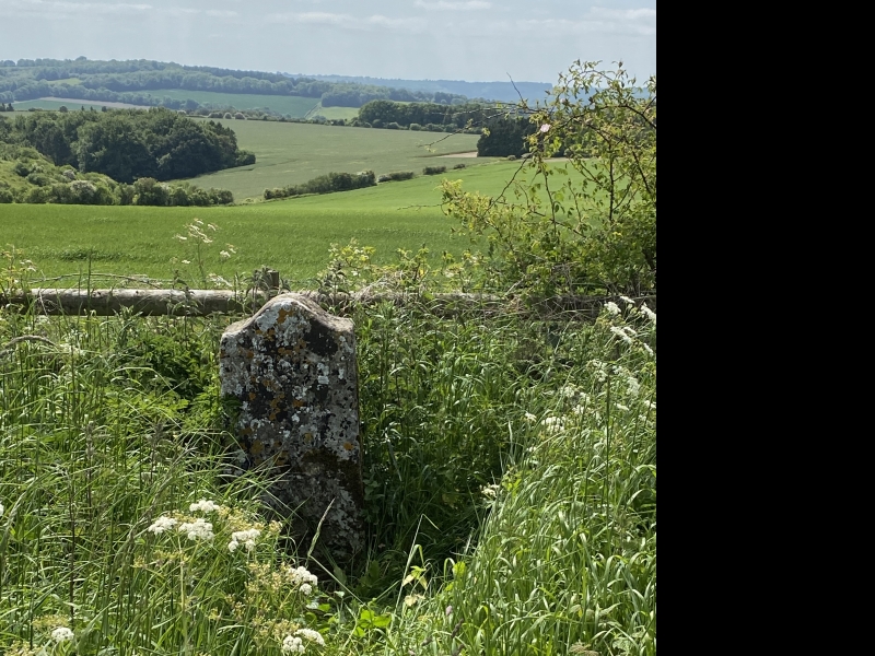
Two guide posts 1910m WNW and 570m north west of Oakley Farm.
Source: Historic England
This record was the subject of a minor enhancement on 21 September 2015. This record has been generated from an "old county number" (OCN) scheduling record. These are monuments that were not reviewed under the Monuments Protection Programme and are some of our oldest designation records.
This monument, which falls into two separate areas, includes two guide posts both situated on the southern side of a track known variously as the ‘Ox Drove’, ‘Old Bath Road’ or ‘Monarch’s Way’ and they are spaced over 1600m apart with the western guidepost on an area of down known as The Bake and overlooking a dry valley and the eastern guide post on a section known as Wylye Down at the head of a different dry valley. Both guide posts are upright and earthfast and measure approximately 1m high, 0.5m wide and 0.3m thick. Both are inscribed: the western one reads ‘XI MILES FROM SARUM 1750’ and the eastern one ‘X MILES FROM SARUM 1750’.
Source: Historic England
Cranborne Chase is an area of chalkland well known for its high number, density and diversity of archaeological remains. These include a rare combination of Neolithic and Early Bronze Age sites, comprising one of the largest concentrations of burial monuments in England, the largest known cursus (a linear ritual monument) and a significant number and range of henge monuments (Late Neolithic ceremonial centres). Other important remains include a variety of enclosures, settlements, field systems and linear boundaries which date throughout prehistory and into the Romano-British and medieval periods. This high level of survival of archaeological remains is due largely to the later history of the Chase. Cranborne Chase formed a Royal Hunting Ground from at least Norman times, and much of the archaeological survival within the area resulted from associated laws controlling land-use which applied until 1830. The unique archaeological character of the Chase has attracted much attention over the years, notably during the later 19th century, by the pioneering work on the Chase of General Pitt-Rivers, Sir Richard Colt Hoare and Edward Cunnington, often regarded as the fathers of British archaeology. Archaeological investigations have continued throughout the 20th century and to the present day. Guide posts are upright markers erected along routeways to indicate, at their most basic, the course of a route, and sometimes further useful information such as destinations and distances. The idea can be traced back to Roman milestones erected by the Roman army in the first centuries AD. During the medieval period, responsibility for way-marking largely fell to the Church, whose marks frequently took the form of crosses, conveniently asserting the Christian faith at the same time as marking the route. This system collapsed with the Reformation, though substantial numbers of crosses still survive in some areas despite deliberate destruction of many route marking crosses. The Turnpike Acts, which enabled tolls to be levied on road users during the 18th century, revolutionised highway maintenance and made provision for guide posts and milestones. A substantial number of turnpike stone guide posts still survive, and as with the contemporary milestones, they are often of a distinctive style peculiar to one Turnpike Trust or to part of a Trust's length of road. Between 1888 and 1930, highways maintenance, including signposting, passed to County and District Councils, with national government taking responsibility for trunk roads in 1936. The locations, style and level of standardisation of guide posts provide very tangible indicators of post- medieval development of the road system; those erected during the 17th and 18th centuries formed an essential stimulus to the growth of the nation's internal trade which provided the setting for the Industrial Revolution. The two guide posts 1910m WNW and 570m north west of Oakley Farm survive intact and in their original locations beside an old route and thus retain their archaeological and landscape context.
Source: Historic England
Other
Wiltshire HER ST93SE526 and SU03SW525
Source: Historic England
Other nearby scheduled monuments