Approximate Location Map
Large Map »
This site is entirely user-supported. See how you can help.
Latitude: 53.1764 / 53°10'35"N
Longitude: -1.0981 / 1°5'53"W
OS Eastings: 460377.047033
OS Northings: 364747.446461
OS Grid: SK603647
Mapcode National: GBR 9G7.Z1S
Mapcode Global: WHFGZ.3FC7
Entry Name: King John's Palace
Scheduled Date: 6 August 1954
Last Amended: 9 March 2018
Source: Historic England
Source ID: 1003481
English Heritage Legacy ID: NT 101
County: Nottinghamshire
Civil Parish: Kings Clipstone
Traditional County: Nottinghamshire
Lieutenancy Area (Ceremonial County): Nottinghamshire
Church of England Parish: Clipstone
Church of England Diocese: Southwell and Nottingham
Royal palace or hunting lodge, built in the mid C12, and operational until the close of the C15. Visited by every English king from Henry II until Richard II.
Source: Historic England
Royal palace or hunting lodge, built in the mid C12, and operational until the close of the C15. Visited by every English king from Henry II until Richard II
PRINCIPAL ELEMENTS:
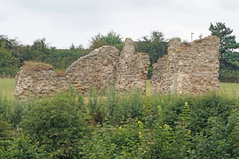
King John’s Palace sits on the north eastern end of a spur of land between the River Maun to the north and the Vicar Water to the south and east. Above the ground, the standing remains comprise the rubble core of the west wall of an unidentified structure, with partial remains of the cores of two other walls running east from the north and south corners. Below ground, the site survives as extensive archaeological remains, robbed out foundations and topsoil artefact spreads.
DESCRIPTION:
The standing remains of King John’s Palace comprise three walls of limestone rubble set in lime mortar survive, approximately 21m x 9m (external dimensions), and standing to a height of more than four metres in places. As only three walls survive, the original plan form is impossible to determine. However, the ground drops away immediately to the east of each end wall, suggesting that either the building or this wing of the building extended to that point. On the external face of the south wall is a deep recess, under a single centred arch. The arch has either a floor level scar or a shelf scar (interpreted by Rahtz as lower and upper floor levels), and the lowest three visible courses of masonry are more regular, and use larger blocks than elsewhere on the standing remains. Several timber sockets are visible on the inner face of the west wall, indicating that the structure once had an upper floor. The west wall is pierced by three openings, one now blocked with pre-cast concrete blocks. While late C18 illustrations of the ruins show four openings (the most northerly is a combination of two openings) as complete arched openings, subsequent masonry collapses have left the south two openings incomplete, with no overhead masonry. The northern openings were subject to a number of collapses, and are now shored with an unsympathetic precast concrete block wall.
Excavation evidence suggests that the outside of the structure was faced with ashlar masonry. This is slightly at odds with the standing remains, where the only remaining ashlar masonry is on the inside at first floor level, although this may, in fact, merely indicate that the upper floor was a much more high status space than the ground floor.
Geophysical survey results show a concentration of disturbance around the standing remains, suggesting that the site is roughly centred on the standing remains. Excavations by Rahtz, Trent and Peak Archaeology and Time Team in the vicinity of the standing remains have uncovered extensive remains of former buildings, primarily in the form of robbed out foundations, demolition layers and occasional in situ masonry fragments. Rahtz and Time Team also found a set of deep foundations to the north of the standing remains, suggestive of the base of a tower mentioned in C15 documents.
A large ditch, visible in geophysical survey results and investigated by trial trenching marked the western boundary of the lodge enclosure. The northern boundary was formed by the road, and included a stone gatehouse, remnants of which are incorporated into the walls of Maun Cottage, Brammer Farm House and Arundel Cottage. The eastern boundary was formed by a fish pond. The southern and north-eastern boundaries are undefined, but can be extrapolated from the existing boundaries, the line of the road and the line of the Vicar Water. The ditch was dated from excavation evidence to the late C13 to early C14, and appears to replace an earlier boundary closer in to the core of the site.
Source: Historic England
King John’s Palace, built in the mid C12, and operational until the close of the C15, is scheduled for the following principal reasons:
* Historic importance 1: for its association with the highest echelons of medieval society, specifically eight named monarchs;
* Historic importance 2: for its role as an administrative centre of Medieval government, including its role as a venue for greeting foreign monarchs and as the site of a meeting of Parliament;
* Documentation: for its documentary record, which catalogues royal visits, new buildings, modifications and repairs ordered, together with the financial accounts for works to the site;
* Archaeological importance: the site has considerable potential to illustrate the phasing, layout and use of the site throughout its history (including its dissolution);
* Potential: for its potential to provide an important insight into the lives and characters of a group at the apex of medieval European society.
Source: Historic England
Books and journals
Pevsner, Nikolaus, Williamson, Elizabeth, The Buildings of England: Nottinghamshire, (2003), 99-100
Wood, M, The English Mediaeval House, (1983), 379, 380 and 384
Wright, J, A Palace for our Kings, (2016)
Rahtz, PA, Colvin, HM , 'King John's Palace, Clipstone' in Transactions of the Thoroton Society of Nottinghamshire, , Vol. 64, (1960), 21-43
Wright, J, 'A Survey of King John's Palace, King's Clipstone, Nottinghamshire' in Transactions of the Thoroton Society of Nottinghamshire, , Vol. 108, (2004), 109-114
Crook, D, 'Clipstone Park and 'Peel'' in Transactions of the Thoroton Society of Nottinghamshire, , Vol. 80, (1976), 35-46
Websites
Brennan, N. King John's Palace, Clipstone, Nottinghamshire Archaeological Evaluation and Assessment of Results. (2011) Wessex Archaeology report 77500, accessed 21 September 2017 from http://www.wessexarch.co.uk/reports/77500/clipstone
Chronology of King's John's Palace and Clipstone Park from the Mansfield Town Council website, accessed 21 September 2017 from http://www.foresttown.net/index.php/heritage/clipstone-park-chronology/
History of King John's Palace, from the Mercian Archaeological Services website, accessed 21 September 2017 from http://mercian-as.co.uk/kjp_sfap.html
Other
Budge, D and Gaunt A. Discover King John's Palace Plough Soil Test Pitting, King's Clipstone, Nottinghamshire (2017) Unpublished Mercian Archaeological Services Report
Gaunt, A. Geophysical Magnetometer Survey of King John's Palace in Sherwood Forest. (2017) Unpublished Mercian Archaeological Services Report
Gaunt, A. Topographic Survey at King John's Palace in Sherwood Forest. (2017) Unpublished Mercian Archaeological Services Report
Masters, P. Fluxgate Gradiometer and Resistivity Surveys: King John's Palace, Clipstone, Nottinghamshire. (2004) Unpublished Pre-Construct Geophysics Report
Sheppard, R. A Small Archaeological Investigation at King John's Palace, Clipstone, Nottinghamshire 1991. (2016) Unpublished Trent and Peak Archaeological Trust Report 008/2016
Wood, E and Adcock, J. King John's Palace, Clipstone, Nottinghamshire. (2011) Unpublished GSB Prospection Report 2011/21
Source: Historic England
Other nearby scheduled monuments