Approximate Location Map
Large Map »
This site is entirely user-supported. See how you can help.
Latitude: 51.9674 / 51°58'2"N
Longitude: -1.9085 / 1°54'30"W
OS Eastings: 406385.401045
OS Northings: 229885.342065
OS Grid: SP063298
Mapcode National: GBR 3MX.Q8Z
Mapcode Global: VHB1D.VTY4
Entry Name: Beckbury camp, Hailes
Scheduled Date: 5 January 1927
Source: Historic England
Source ID: 1003319
English Heritage Legacy ID: GC 33
County: Gloucestershire
Civil Parish: Temple Guiting
Traditional County: Gloucestershire
Lieutenancy Area (Ceremonial County): Gloucestershire
Church of England Parish: Guiting Power St Michael
Church of England Diocese: Gloucester
Slight univallate hillfort called ‘Beckbury Camp’.
Source: Historic England
This record was the subject of a minor enhancement on 8 July 2015. The record has been generated from an "old county number" (OCN) scheduling record. These are monuments that were not reviewed under the Monuments Protection Programme and are some of our oldest designation records.
Slight univallate hillforts are defined as enclosures of various shapes, generally between 1ha and 10ha in size, situated on or close to hilltops and defined by a single line of earthworks, the scale of which is relatively small. They date to between the Late Bronze Age and Early Iron Age (eighth - fifth centuries BC), the majority being used for 150 to 200 years prior to their abandonment or reconstruction. Slight univallate hillforts have generally been interpreted as stock enclosures, redistribution centres, places of refuge and permanent settlements. The earthworks generally include a rampart, narrow level berm, external ditch and counterscarp bank, while access to the interior is usually provided by two entrances comprising either simple gaps in the earthwork or an inturned rampart. Postholes revealed by excavation indicate the occasional presence of portal gateways while more elaborate features like overlapping ramparts and outworks are limited to only a few examples. Internal features included timber or stone round houses; large storage pits and hearths; scattered postholes, stakeholes and gullies; and square or rectangular buildings supported by four to six posts, often represented by postholes, and interpreted as raised granaries. Slight univallate hillforts are rare with around 150 examples recorded nationally. Although on a national scale the number is low, in Devon they comprise one of the major classes of hillfort. In other areas where the distribution is relatively dense, for example, Wessex, Sussex, the Cotswolds and the Chilterns, hillforts belonging to a number of different classes occur within the same region. Examples are also recorded in eastern England, the Welsh Marches, central and southern England. They are rare and important for understanding the transition between Bronze Age and Iron Age communities.
The slight univallate hillfort called ‘Beckbury’ survives well and will contain archaeological and environmental evidence relating to its construction, longevity, trade, agricultural practices, social organisation, territorial significance, domestic arrangements and overall landscape context.
Source: Historic England
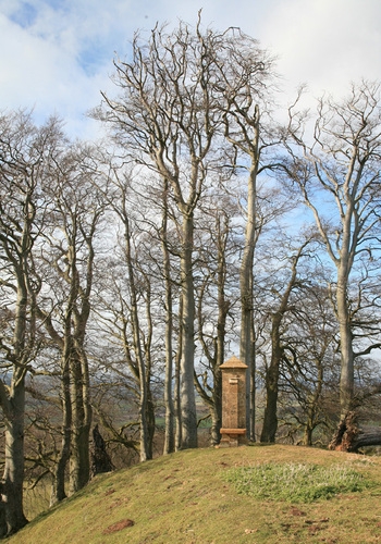
This monument includes a slight univallate hillfort situated on a wide limestone plateau forming part of the Cotswold Hills at the summit of a steep scarp overlooking the wide valley of the River Isbourne. The hillfort survives as a roughly rectangular enclosure defined by natural scarp slopes to the north and west and by a rampart bank of up to 4m high with a buried ditch to the south and east and in all measures approximately 169m long by 131m wide. In the north western corner on the site of a spring is a 19th century limestone built structure with alcoves, basins and an extending stone slab known as ‘Cromwell’s Seat’ which allegedly marks the spot where Thomas Cromwell (Chief Minister of Henry VIII 1532 -1540) watched Hailes Abbey burning in the valley below following its dissolution. This feature is marked on the maps as a ‘Monument’.
Source: Historic England
Other
PastScape 327715
Source: Historic England
Other nearby scheduled monuments