Approximate Location Map
Large Map »
This site is entirely user-supported. See how you can help.
Latitude: 53.0356 / 53°2'8"N
Longitude: -1.2685 / 1°16'6"W
OS Eastings: 449146.617043
OS Northings: 348948.412209
OS Grid: SK491489
Mapcode National: GBR 7F3.Q3X
Mapcode Global: WHDGB.HY5R
Entry Name: Beauvale Carthusian Priory
Scheduled Date: 10 April 1915
Last Amended: 15 May 2014
Source: Historic England
Source ID: 1002920
English Heritage Legacy ID: NT 1
County: Nottinghamshire
Civil Parish: Greasley
Traditional County: Nottinghamshire
Lieutenancy Area (Ceremonial County): Nottinghamshire
Church of England Parish: Greasley
Church of England Diocese: Southwell and Nottingham
Beauvale Priory built in 1343 by Sir Nicholas de Cantilupe.
Source: Historic England
Beauvale Priory lies between 114m and 130m above OD, over coal measure deposits with outcropping sandstone beds. The Priory sits at the head of a minor un-named stream valley, on a gently sloping terrace on the northern side of the valley. The stream is oriented north-east to south-west and was fed from the north by at least one north to south valley, which has been incorporated into the layout of the Priory. The position of the Priory also allowed it to take advantage of the natural shelter offered by Abbey Wood to the north and the natural springs situated within it, including Robin Hood’s Well. Additionally building stone was readily available in extensive stone quarries about 150m north of the site, the likely source of building stone for the medieval structures.
PRINCIPAL ELEMENTS
The site includes the earthwork, buried and standing remains of Beauvale Priory including the precinct wall, Church, Prior's Lodgings, cloister, causeway, fishponds and ridge and furrow. From the standing remains and the earthworks preserved at Beauvale the plan of the Carthusian priory may be understood. The principal axis of the site is set east to west, the church positioned within the eastern half of the enclosure.
DESCRIPTION
The standing structures and earthwork remains of the priory buildings sit roughly central to the scheduled area. The remains of the Priory Church and attached Prior’s Lodgings, the precinct boundary wall and the Gatehouse are all listed. Detailed descriptions of the buildings are available on the National Heritage List for England (NHLE 1278052, 1278053 and 1248104 respectively) and will only be summarised here.
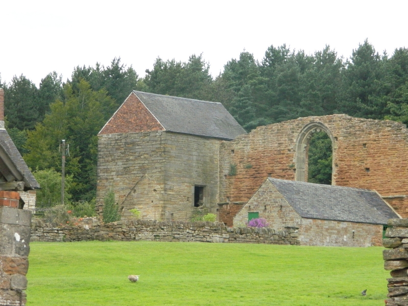
The remains of the Priory Church and attached Prior’s Lodgings form an L-shaped complex of buildings, the site of the church represented by substantial sections of the nave north and south side walls, which stand to a height of c.5m. The nave south wall is c.20m in length and is the more substantial of the two. It retains on its southern face a pointed arched doorway to the west side, the arch head with a simple, deep chamfer. Attached to the south nave wall at its west end, and extending southwards is a tall-roofed building identified as the Prior's Lodgings. Its north-east corner incorporates the moulded south jamb of the church’s west window. At the east end of the south wall is a single-storied outbuilding built against, but not bonded into, the medieval walling.
A section of the former Priory precinct wall survives on the eastern side of the site, its southern end 10m to the north of the gatehouse rear range north gable. The standing remains of the wall are c.85m in length, surviving to a maximum height of c.2m at the south end, diminishing to 1.5m at the north end. At approximately 15m from the south end is a narrow rebated doorway with ashlar dressings. Along the length of the wall at c.3m intervals are small square openings, set below deep rubble lintels. The wall aligns with the east wall of the rear range of the gatehouse and evaluation of the area in advance of repair work has shown that the wall continued south, presumably to the gatehouse. Geophysical survey (RCHME 1995) has also identified a continuation of the wall northwards, although the alignment of the wall deviates eastwards from the line of the current field boundary.
The remains of the former gatehouse to the Priory is located to the south of the site, and forms the frontage range to a small courtyard of farm outbuildings which are not included in the scheduling. The remains of the gatehouse are incorporated into the fabric of the building now used partially as a visitor café facility. The other part of the building is presently unused. Built in coursed rubble sandstone and red brick, with C20 plain clay tile and corrugated sheeting roof coverings the building is L-shaped on plan, with a rear wing extending northwards on the alignment of the surviving area of precinct wall to the north.
The present access to the Priory approaches from the south-east, the track crossing the valley on a raised earthen causeway c.17m across at its base and 5m in height. The brick culvert which carries the stream under the causeway appears to be constructed in relatively modern brick. The track is aligned directly with the gatehouse (now converted to a tea room) although access to the current Abbey Farmhouse now diverts to the east cutting through the precinct wall.
Another possible approach to the Priory is via another small causeway c.185m to the south-west of the main causeway, again crossing the valley. An alternative interpretation for this earthwork, which is c.12m wide and c.2m in height, is that it functioned as a pond dam, although it is possible that it had a dual function.
The main cloister at Beauvale was to the west of the church, the inner edge of the surrounding walk aligned approximately with the boundary around the current orchard, west of the farmhouse. Parts of the site were excavated in 1908 (De Boulay and Hill 1909) with the northern side of the cloister being the focus of the investigations. Some earthworks visible in this area today appear to be the results of backfilling, spoil heaps and trenches relating to these excavations. The report from the investigations describes five cells and gardens aligned along the north side of the cloister, these are still discernable on the ground by low linear banks, with an L shaped garden curving around an off-centre cell. The middle cell was entirely exposed but the position of the structure is still visible as a sub-rectangular hollow c.9m by 6m.
Earthworks around the western and southern sides of the cloister are less clear but geophysical surveys carried out in March and June 1995 reveal a very clear layout of the structural remains of cells and gardens, mirroring the evidence exposed though excavation on the northern side. In addition, the geophysical survey revealed a leat running parallel to the rear wall of the gardens on the north and western side and this is evident on the surface as a shallow, linear ditch c.13m wide c.0.5m deep. This may have provided piped water to individual cells similar to those at the Carthusian Priory at Mount Grace and at The London Carthusian charterhouse (Coppack 1990).
South of the cloister a clearly defined scarp runs parallel to the hedgerow and appears to represent the edge of the cloistral range, fragments of a wall found during excavation substantiate this interpretation. South of this lies a large sub-rectangular pond, held by a large earthen dam up to 13m wide and 2.3m in height on its southern side. The steep northern side of the pond cuts the adjacent features but this may be the result of erosion of the northern bank or redefining of the pond at a later date. The pond may have extended further east but this area has been used as a slurry pit. Between the slurry pit and the gatehouse the area is now occupied by a modern barn and made ground to form a level area in front of the barns. This area is now used as a car park for the tea rooms.
The archaeological survey report (RCHME 1991-2) suggests that the garden east of Abbey Farmhouse is the site of a second smaller cloister; the farmhouse forming the west side of it, the northern side delimited by the church and the eastern by the garden wall. Whether the cloister was closed on the southern side is unknown. Between this cloister and the precinct boundary wall to the east the pasture is relatively smoothed with some of the scarps representing former farm tracks. Other scarps define levels within the field and against the boundary wall which possibly represent former building platforms. Comparison with Mount Grace Priory (Coppack 1991) suggests this may have contained accommodation for the lay brothers.
The earthwork and standing remains of the monastic buildings are enclosed to the north and west by an earthen bank up to 13m wide and, along the northern side c.2.7m high dropping to c.1.5m along the western side. A ditch c.2.5m wide is evident along the outside of the bank for much of its length. A shallow terrace or berm is present along most of the internal side of the western bank but is not as well defined as along the northern side. This may partly be the consequence of soil movement over the berm. At the southern end of the western bank is a farm gate. Although there is little evidence of erosion now, in the past erosion has distorted the original form of the earthworks. The enclosure of the monastic buildings on the south side is completed by the pond, and on the eastern side by the precinct boundary wall, but the outer boundary, potentially forming an outer precinct may be defined by the large rectangular pond to the north-east of the gatehouse. The pond is aligned north-east to south-west and is retained at the north-eastern end by a dam, while at the other end the profile of the pond has been distorted by deposits which make up the ground around the existing farm yard. On the northern side of the valley a dam some 22m wide and up to 2.5m in height were recorded during the archaeological survey of 1991-2, but the pond has, in recent, years been restored and the dam on the northern side although still evident is not as clearly defined.
Running north from the east end of the pond is a slight banked feature which after c.50m turns to the west and heads directly in line with the rear wall of the cell gardens in the northern range of the cloister. The continuity of this feature is broken by a farm track cutting through the precinct boundary wall. This bank appeared as a clear feature in the archaeological survey of 1991-2 and although still faintly evident it is somewhat rounded and degraded today.
The earthworks around the Priory represent the remains of agricultural activity. In the field north of the large pond and east of the precinct boundary wall are the remains of ridge and furrow cultivation. Across the top of the field a sharpening of the natural fall by an artificial scarp probably marks the headland of the ploughed area. In the field to the south-east of the Priory is a palimpsest of archaeological phases culminating in narrow ridge and furrow overlain at the southern end by the railway embankment. At the northern end the movement of soil through ploughing has created a lynchet on the valley side. Marked linear hollows lying on the same alignment as the ridge and furrow probably represent earlier field boundaries as these are, in places, overlain by ridge and furrow.
EXTENT OF SCHEDULING
The scheduled monument forms a sub-triangular shaped area defined on the north and west sides by the edge of Abbey Wood and on the south side by the un-named stream which crosses the site east to west, but the scheduled area includes a 30m wide strip south of the stream to include earthworks abutting the main causeway. The gatehouse and the remains of the Church, Prior's Lodgings, and the precinct boundary wall are all currently listed but are also included in the scheduling. The Grade II listed Abbey Farmhouse is a dwelling and therefore more appropriately managed through its listed building status. As such the farmhouse is excluded from the scheduling although the ground beneath the building is included. All modern paths and track surfaces, fences and drain covers are excluded from the scheduling but again the ground beneath is included. The C20 memorial stone to Houghton and Lawrence at the east end of the church, the courtyard of farm buildings to the north of the gatehouse and other farm buildings are also all excluded from the scheduling, although the ground beneath all of them is included.
There is considerable potential for undesignated (but potentially national important) remains to survive outside the scheduled area, particularly on the southern side where remnants of medieval field boundaries are thought to underlie post-medieval, narrow ridge and furrow.
Source: Historic England
Beauvale Carthusian Priory, built in 1343 by Sir Nicholas de Cantilupe, is scheduled for the following principal reasons:
* Survival: for the exceptional standing, buried and earthwork remains, depicting the form, plan and architectural detail of the priory;
* Potential: for the stratified archaeological deposits which retain considerable potential to increase our understanding of the physical characteristics of the buildings at Beauvale. Buried artefacts and sediments will also have the potential to increase our knowledge and understanding of the social and economic functioning of a Carthusian community within the wider medieval landscape;
* Documentation: for the high level of historical and archaeological documentation pertaining to the Priory’s history and evolution and to the significance of the former incumbents who were some of the first martyrs to rebel against Henry VIII's Act of Succession;
* Diversity: for the range and complexity of features such as the Church, Prior's Lodging, cloister, cells and gardens, fishponds and ridge and furrow which, taken as a whole, provide a clear plan of the Priory and retain significant stratified deposits which serve to provide details of the continuity and change in the evolution of the monastic site;
* Rarity: as one of only nine Carthusian houses to have been built in England. It represents a very specific period in history and a clearly defined monastic order who gained great respect for maintaining their austere standards up until the Dissolution.
Source: Historic England
Books and journals
Coppack, G, Aston, M, Christ's Poor Men, (2002)
Coppack, G, Abbeys and Priories, (1990)
Knowles, D, Hadcock, R. N, Medieval Religious Houses in England and Wales, (1971)
Roberts, M, The story of Beauvale Priory and the Martyrs
Du Boulay Hill, Rev A, Gill, H, 'Transactions of the Thoroton Society' in Beauvale Charter House Notts, , Vol. XII, (1908), 70-94
Other
Nottinghamshire Historic Environment Record,
RCHME - repot no. 95/10, Beauvale Priory Nottinghamshire., 1995,
RCHME report no. 95/52, Beauvale Priory II Nottinghamshire, 1995,
RCHME, Beauvale Priory, Nottinghamshire Archaeological Survey Report, 1991-2,
Source: Historic England
Other nearby scheduled monuments