Approximate Location Map
Large Map »
This site is entirely user-supported. See how you can help.
Latitude: 51.6791 / 51°40'44"N
Longitude: -2.2032 / 2°12'11"W
OS Eastings: 386046.278629
OS Northings: 197832.5925
OS Grid: ST860978
Mapcode National: GBR 1NC.MSP
Mapcode Global: VH95B.R2M4
Entry Name: Lechmore long barrow
Scheduled Date: 1 January 1900
Source: Historic England
Source ID: 1002114
English Heritage Legacy ID: GC 281
County: Gloucestershire
Civil Parish: Horsley
Traditional County: Gloucestershire
Lieutenancy Area (Ceremonial County): Gloucestershire
Church of England Parish: Horsley St Martin
Church of England Diocese: Gloucester
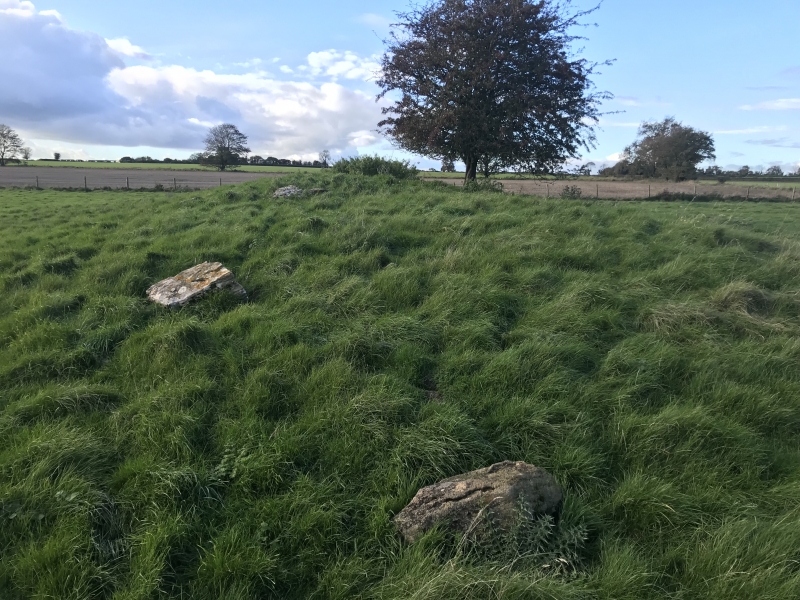
Long barrow 675m south west of Brandhouse Farm.
Source: Historic England
This record was the subject of a minor enhancement on 24 September 2015. The record has been generated from an "old county number" (OCN) scheduling record. These are monuments that were not reviewed under the Monuments Protection Programme and are some of our oldest designation records.
The monument includes a long barrow situated on a ridge at the head of a valley of a tributary to the Nailsworth Stream which first runs into the Ledgemore Pond. Known locally also as ‘Ledgemore Long Barrow’ it survives as an elongated roughly rectangular mound aligned ESE to WNW and measuring up to 24.3m long, 12.1m wide and 1.8m high with the side ditches preserved as buried features. Partial excavations in 1812 revealed a single stone lined chamber but this had been dismantled by 1870. Further large in-situ stones are visible within the mound. Further archaeological remains in the immediate vicinity are the subject of a separate scheduling.
Source: Historic England
Long barrows were constructed as earthen or drystone mounds with flanking ditches and acted as funerary monuments during the Early and Middle Neolithic periods (3400-2400 BC). They represent the burial places of Britain's early farming communities and, as such, are amongst the oldest field monuments surviving visibly in the present landscape. Where investigated, long barrows appear to have been used for communal burial, often with only parts of the human remains having been selected for interment. Certain sites provide evidence for several phases of funerary monument preceding the barrow and, consequently, it is probable that long barrows acted as important ritual sites for local communities over a considerable period of time. Some 500 examples of long barrows and long cairns, their counterparts in the uplands, are recorded nationally. As one of the few types of Neolithic structure to survive as earthworks, and due to their comparative rarity, their considerable age and their longevity as a monument type, all long barrows are considered to be important.
Despite partial early excavation the long barrow 675m south west of Brandhouse Farm survives comparatively well and will contain archaeological and environmental evidence relating to its construction, longevity, territorial significance, social organisation, funerary and ritual practices and overall landscape context.
Source: Historic England
Other
PastScape 208897
Source: Historic England
Other nearby scheduled monuments