Approximate Location Map
Large Map »
This site is entirely user-supported. See how you can help.
Latitude: 51.8268 / 51°49'36"N
Longitude: -4.8711 / 4°52'16"W
OS Eastings: 202245
OS Northings: 218140
OS Grid: SN022181
Mapcode National: GBR CQ.W0DM
Mapcode Global: VH1RG.JB5X
Entry Name: Wiston Castle
Scheduled Date:
Source: Cadw
Source ID: 3709
Cadw Legacy ID: PE077
Schedule Class: Defence
Category: Motte & Bailey
Period: Medieval
County: Pembrokeshire (Sir Benfro)
Community: Wiston (Cas-wis)
Traditional County: Pembrokeshire
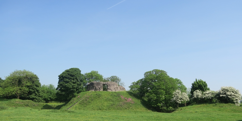
The monument comprises the remains of a motte and bailey castle, a military stronghold built during the medieval period. A motte and bailey castle comprises a large conical or pyramidal mound of soil or stone (the motte) surrounded by, or adjacent to, one or more embanked enclosures (the bailey). Both may be surrounded by wet or dry ditches and could be further strengthened with palisades, revetments, and/or a tower on top of the motte. The motte at Wiston measures c 50m in diameter is c 9m high and 18m in diameter at its summit. On the flat top are the ruins of a shell keep or encircling stone wall that formed the main defence, within this would have stood other, probably timber buildings. Internally the shell keep wall is circular but externally the face is polygonal having 18 sides. On the south side facing the bailey, is an arched entrance on either side of which are draw holes for securing a wooden gate. The wall varies from 1.5 to 2m in width and now stands 3 to 4m in height. The large oval bailey measures c 130m east to west by 90m and is surrounded by a bank which crosses the motte ditch to abut the motte mound. The bailey ditch survives on the north and west but is filled in on the other two sides. The entrance to the bailey is on the north east, strengthened by an outer protective earthwork.
The castle was probably established by an early Flemish settler Wizo (d 1130) and is first mentioned in 1147 when taken by the Welsh. It was taken again in 1193 when it apparently fell by treachery, to Hywel Sais, the son of the Lord Rhys, but was recaptured in 1195. In 1220 during one of his campaigns of Llywelyn the Great, Prince of Gwynedd in south Wales it was captured and destroyed. Though ordered rebuilt by William Marshall, earl of Pembroke as no further masonry additions were made it can be assumed the castle was abandoned sometime soon afterwards.
The monument is of national importance for its potential to enhance our knowledge of medieval defensive organisation. The well-preserved monument forms an important element within the wider medieval context and the structure itself may be expected to contain archaeological information relating to chronology, building techniques and functional detail.
The scheduled area comprises the remains described and areas around them within which related
Source: Cadw
Other nearby scheduled monuments