Approximate Location Map
Large Map »
This site is entirely user-supported. See how you can help.
Latitude: 53.3605 / 53°21'37"N
Longitude: -4.2551 / 4°15'18"W
OS Eastings: 250027
OS Northings: 387216
OS Grid: SH500872
Mapcode National: GBR HMVT.KM4
Mapcode Global: WH428.LSZN
Entry Name: Traeth Lligwy Fish Weir
Scheduled Date: 31 October 2002
Source: Cadw
Source ID: 3897
Cadw Legacy ID: AN144
Schedule Class: Maritime
Category: Fish weir
Period: Medieval
County: Isle of Anglesey (Ynys Môn)
Community: Moelfre
Traditional County: Anglesey
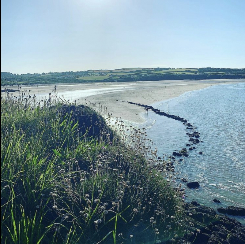
Traeth Lligwy Fish Weir is a well-preserved example of a medieval or post-medieval, crescent-shaped fish weir. A fish weir is usually characterised by a foundation of stone topped with a fence or row of stakes, often with nets attached forming an enclosure within a river or harbour and used for catching, or holding, fish. Traeth Lligwy Fish Weir comprises a single, curving arm defined by the remains of stone-built walls. The weir wall is 4m wide and survives to a height of approximately 0.6m with surviving facing on the upper portion of the interior face. It runs at 90 degrees out from the shore for 45m before turning towards the west to form a long, curving arm running parallel to the shore for 103m. The site is located under the low north-western cliff-face of Trwyn Cribin - the headland that forms the eastern margin of Traeth Lligwy Bay.
Being the best preserved of surviving weirs of this type in Gwynedd, Traeth Lligwy retains substantial archaeological potential. Its simple form may indicate an early date within the local sequence. The scheduled area is a truncated rectangle some 150m by 120m aligned south-west to north-east with its south-eastern boundary formed by the mean high water mark.
Source: Cadw
Other nearby scheduled monuments