Approximate Location Map
Large Map »
This site is entirely user-supported. See how you can help.
Latitude: 51.7523 / 51°45'8"N
Longitude: -5.203 / 5°12'10"W
OS Eastings: 179018
OS Northings: 210810
OS Grid: SM790108
Mapcode National: GBR G2.FX2M
Mapcode Global: VH0V6.R7R1
Entry Name: Tower Point Rath
Scheduled Date: 17 June 1952
Source: Cadw
Source ID: 3060
Cadw Legacy ID: PE281
Schedule Class: Defence
Category: Promontory Fort - inland
Period: Prehistoric
County: Pembrokeshire (Sir Benfro)
Community: Marloes and St. Brides (Marloes a Sain Ffrêd)
Traditional County: Pembrokeshire
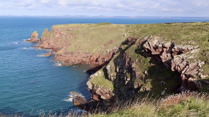
The monument comprises the remains of a defended enclosure, which probably dates to the Iron Age period (c. 800 BC - AD 43). The enclosure is located on a coastal promontory above 40m high sea cliffs to the north and west. To the east the enclosure is defended by an approximately 140m long system of triple banks and intermediate ditches consisting of an inner bank 14.5m wide and 3m high, outside of which is a ditch, then a slight central bank, another ditch and finally a slight outer bank, 9m wide and 0.8m high. The entrance is north of centre through the ramparts and here the inner rampart is flattened on its north side whilst on the south side there is a depression in the terminal suggestive of a guard chamber. Excavations in 1970 demonstrated the inner bank was of two phases; the first phase was of clay faced with stone; in the second phase the bank was heightened with stepped and revetted walls - murus duplex. A vestigial internal, oval structure, 11m by 9.5m probably represented a hut. Geophysical survey in 2015 demonstrated a linear formation of possible pits or post holes near the eastern edge of the interior facing the entrance, as well as a number of discrete areas of possible burning within the interior.
The monument is of national importance for its potential to enhance our knowledge of later prehistoric defensive organisation and settlement. The site forms an important element within the wider later prehistoric context and within the surrounding landscape. The site is well preserved and retains considerable archaeological potential. There is a strong probability of the presence of evidence relating to chronology, building techniques and functional detail.
The scheduled area comprises the remains described and areas around them within which related evidence may be expected to survive.
Source: Cadw
Other nearby scheduled monuments