Approximate Location Map
Large Map »
This site is entirely user-supported. See how you can help.
Latitude: 52.7106 / 52°42'38"N
Longitude: -3.6891 / 3°41'20"W
OS Eastings: 285988
OS Northings: 313892
OS Grid: SH859138
Mapcode National: GBR 99.26CK
Mapcode Global: WH683.94K8
Entry Name: Pont Minllyn
Scheduled Date:
Source: Cadw
Source ID: 2479
Cadw Legacy ID: ME094
Schedule Class: Transport
Category: Bridge
Period: Post Medieval/Modern
County: Gwynedd
Community: Mawddwy
Traditional County: Merionethshire
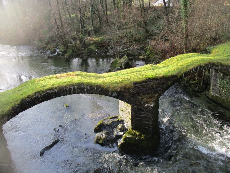
The monument consists of the remains of a bridge, dating to the post-medieval period. Pont Minllyn, also known as Pont y Ffinant or Pontrusk Bridge, crosses the river Dovey at a long-established point also used by two more recent bridges. The scheduled bridge is no longer in use, and is reduced to little but the turfed arch-rings, with no parapets or road surfacing surviving. A bridge shown at this point on Saxton’s map of 1578 was probably built of timber, the present example having been constructed by Dr. Davies, who was Rector of Mallwyd from 1604 to 1644. It has two segmental arches spanning c.18m, and is 2.5m wide. Each arch is composed of a single ring of stone voussoirs, with a triangular pier between the arches. The bridge was described as an ‘ivy-clad bridge of two arches’ by J G Wood in 1813, suggesting that it remained in use at that date.
The monument is of national importance for its potential to enhance our knowledge of medieval or post-medieval construction techniques and transportation systems. It retains significant archaeological potential, with a strong probability of the presence of associated archaeological features and deposits. The structure itself may be expected to contain archaeological information concerning chronology and building techniques.
The scheduled area comprises the remains described and areas around them within which related evidence may be expected to survive.
Source: Cadw
Other nearby scheduled monuments