Approximate Location Map
Large Map »
This site is entirely user-supported. See how you can help.
Latitude: 52.4689 / 52°28'8"N
Longitude: -3.6085 / 3°36'30"W
OS Eastings: 290833
OS Northings: 286882
OS Grid: SN908868
Mapcode National: GBR 9D.KG7K
Mapcode Global: VH5BW.D6QN
Entry Name: Pen-y-Gaer Camp
Scheduled Date:
Source: Cadw
Source ID: 2990
Cadw Legacy ID: MG085
Schedule Class: Defence
Category: Hillfort
Period: Prehistoric
County: Powys
Community: Llanidloes Without (Llanidloes Allanol)
Traditional County: Montgomeryshire
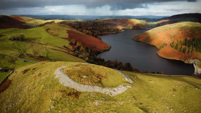
The monument comprises the remains of a hillfort, which probably dates to the Iron Age period (c. 800 BC - AD 74, the Roman conquest of Wales). Hillforts are usually located on hilltops and surrounded by a single or multiple earthworks of massive proportions. Hillforts must have formed symbols of power within the landscape, while their function may have had as much to do with ostentation and display as defence. Pen-y-Gaer Camp comprises a circular enclosure on the summit of Pen y Gaer. There is no sign of a surrounding ditch, but the whole summit is surrounded by a collapsed, dry-stone wall which has spread to a width of c. 10-13m and up to 0.5m high internally, although in most places it is level with the interior. The enclosure measures c. 68m N-S, internally, and 44m transversely, and encloses an area of c. 0.3ha. An entrance is visible in the south. There are very steep natural slopes to east and west, with more gentle approaches to north and south, defended by outworks. A modern cairn 4m x 1.4m high occupies the highest point in the SW corner of the enclosure.
The monument is of national importance for its potential to enhance our knowledge of later prehistoric defensive organisation and settlement. The site forms an important element within the wider later prehistoric context and within the surrounding landscape. The site is well preserved and retains considerable archaeological potential. There is a strong probability of the presence of evidence relating to chronology, building techniques and functional detail.
The scheduled area comprises the remains described and areas around them within which related evidence may be expected to survive.
Source: Cadw
Other nearby scheduled monuments