Approximate Location Map
Large Map »
This site is entirely user-supported. See how you can help.
Latitude: 59.9367 / 59°56'11"N
Longitude: -1.274 / 1°16'26"W
OS Eastings: 440673
OS Northings: 1117073
OS Grid: HU406170
Mapcode National: GBR R26G.NYK
Mapcode Global: XHD49.THFR
Entry Name: Troswick, water mill complex N of
Scheduled Date: 22 December 1969
Last Amended: 12 July 2012
Source: Historic Environment Scotland
Source ID: SM2859
Schedule Class: Cultural
Category: Industrial: mill, factory; Secular: mill (domestic / small-scale)
Location: Dunrossness
County: Shetland Islands
Electoral Ward: Shetland South
Traditional County: Shetland
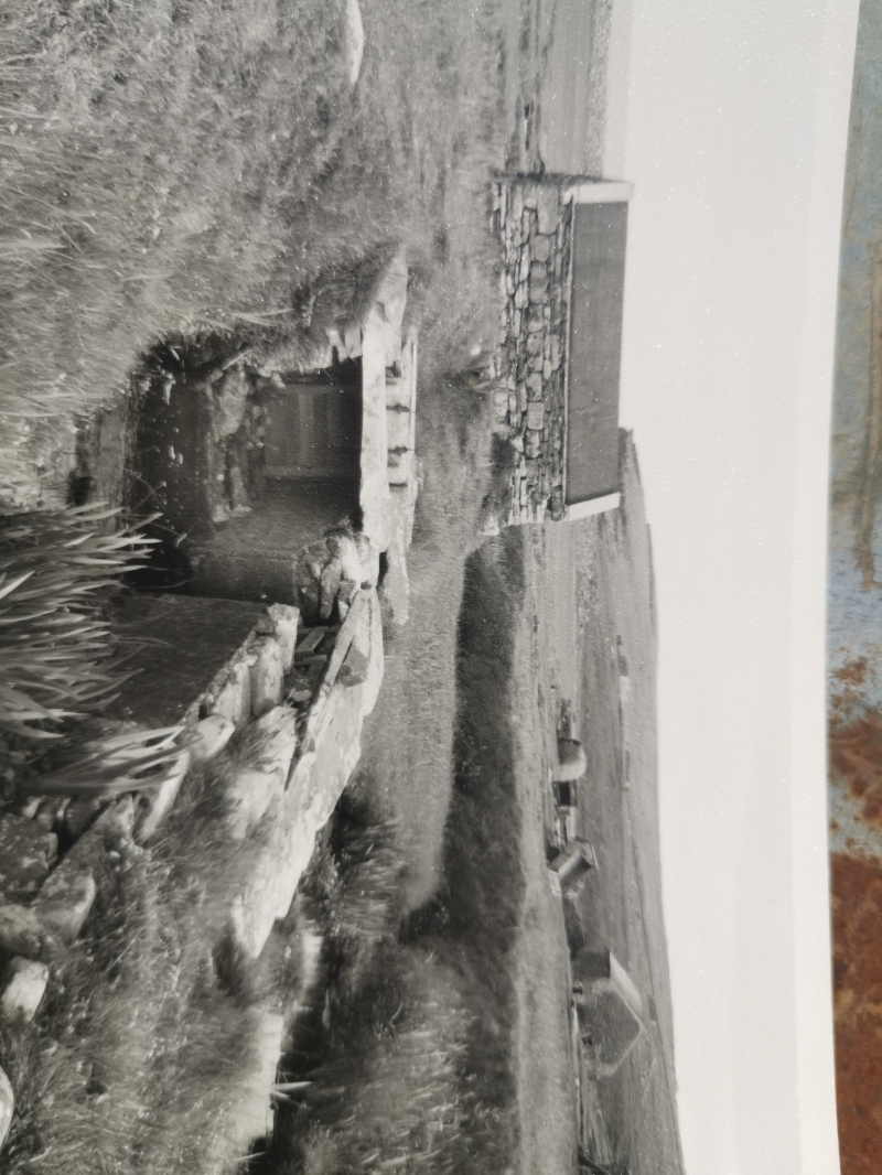
The monument comprises a linear sequence of nine 'horizontal' mills, positioned along a 450m stretch of the Burn of Clumlie. The monument includes a series of ruined mill buildings and the remains of their milling apparatus, as well as a water management system working downstream from a dam into a series of water channels, sluices and lades. The mills lie between the Loch of Clumlie to the NNW, which was the main water source, and boggy ground at Troswick Meadow to the SSE (immediately above the beach at Shelly Geo). Nine individual mills were built here, of which seven survive as upstanding remains. The average size of each mill is approximately 5m long by 4m wide and most still stand 1.5-2m high at their gable ends. The walls are primarily rubble-built with stone lintels, but some may have had turf wall-heads. The monument was first scheduled in 1969, but the documentation does not meet modern standards: the present rescheduling rectifies this.
The area to be scheduled is irregular on plan and comprises two separate polygons, to include the remains described above and an area around them within which evidence relating to the monument's construction, use and abandonment may survive, as shown in red on the accompanying map. The scheduling specifically excludes the above-ground elements of the lowest mill (which was reconstructed in 1929), all post-and-wire fences, all modern service pipes, and a telecommunications pole and its anchor points, to allow for their maintenance.
Source: Historic Environment Scotland
Cultural Significance
The monument's cultural significance can be expressed as follows:
Intrinsic characteristics
The monument survives as the remains of a series of stone and turf buildings, connected by stone-lined and artificially-cut water channels. The remains of two dams upstream mark the start of the system. The monument survives in very good condition with the overall footprint and architectural form of the mills clear to see. The design of these simple twin-level mill buildings and the arrangement of space around the horizontal paddle wheels are clearly visible. The main elements of the water supply system are equally well preserved. An upper dam and the various sluices and lades attached to each mill still allow for the operation of the lowest visible mill. There are at least six relocated millstones along the course of the mills.
These remains offer an important opportunity to examine the construction, form and operation of a sequence of horizontal mills. Together they have high potential to help elucidate the origins, chronology and development sequence of horizontal mills, and to help us understand how the water supply system was harnessed for power generation across a series of mills.
Contextual characteristics
The remains of horizontal mills are relatively uncommon and this example is especially interesting because it is one of the largest and best preserved water-powered systems of its type in Shetland. It is one of several hundred that probably once existed in Shetland. Researchers believe that the distribution of this type of mill is restricted to northern Scotland, especially the Northern Isles. This is, however, one of only a handful of surviving systems and is especially notable because of the number of mills surviving along this one burn. The horizontal (as opposed to vertical) position of the paddle wheel has many advantages, including that it was relatively simple to build and generally used fewer raw materials. These factors resulted in this being the dominant form of mill technology in Shetland, probably from the Norse period for over a thousand years.
A typical mill would have included a small building containing a lower room (or chamber) where running water was channelled to apply force to a horizontally-rotating paddle wheel. The wheel in turn was connected to a vertical axle and two millstones housed in the upper chamber. Where several of these mills were located on the same watercourse, and were operated at the same time, an element of collaboration between operators was necessary. Lades and sluices were therefore important in the control of the water supply to each. At Troswick, the mills could operate independently according to the position of the sluice immediately upstream from each.
Researchers have suggested that these mills have more in common with a Scandinavian tradition (hence the term, 'Norse mill) than those which use vertically mounted wheels elsewhere in Britain. Recent excavations at Orphir in Orkney demonstrated that this type of mill was in use in the Norse period at least in Orkney, and probably in Shetland too. Isles. Horizontal mills were still in use in places in Britain and elsewhere in Europe (such as the Balkans) in the early 20th century. The visible remains at Troswick are likely to date from the 19th century.
Mills and mill complexes obviously had to be located on or adjacent to a suitable water source (which could sometimes result in seasonal use only), but their positioning also has much to tell us about the agricultural and industrial development of the countryside, including changing settlement patterns and wider land-use.
Associative characteristics
The first edition Ordnance Survey map indicates that nine horizontal mills were located at Troswick in the late 19th century.
National Imporatance
This monument is of national importance because it has an inherent potential to make a significant addition to our understanding of the past, in particular the processing of cereal crops as part of the development and industrialisation of agriculture. The surviving buildings, structures and machinery can help us to understand more about the origins, construction, use, dating and development sequence of horizontal water mills. The loss of the monument would significantly diminish our future ability to appreciate and understand the way that past agricultural communities co-operated to improve key agricultural processes.
Source: Historic Environment Scotland
Bibliography
Records indicate that lowest of the mills (Mill 7) was reconstructed in 1929.
RCAHMS records the site as HU41NW 13, 18, 19, 20, 21, 22, 23, 24, 25, 27 and 28. The Shetland Amenity Trust SMR reference is MSN639 (PrefRef 639).
Goudie, G, 1886, 'On the horizontal water mills of Shetland', Proc Soc Antiq Scot, 20, 257-97.
Source: Historic Environment Scotland
Other nearby scheduled monuments