Approximate Location Map
Large Map »
This site is entirely user-supported. See how you can help.
Latitude: 60.2964 / 60°17'46"N
Longitude: -1.6892 / 1°41'21"W
OS Eastings: 417279
OS Northings: 1156954
OS Grid: HU172569
Mapcode National: GBR Q15J.BRY
Mapcode Global: XHBVN.DG1H
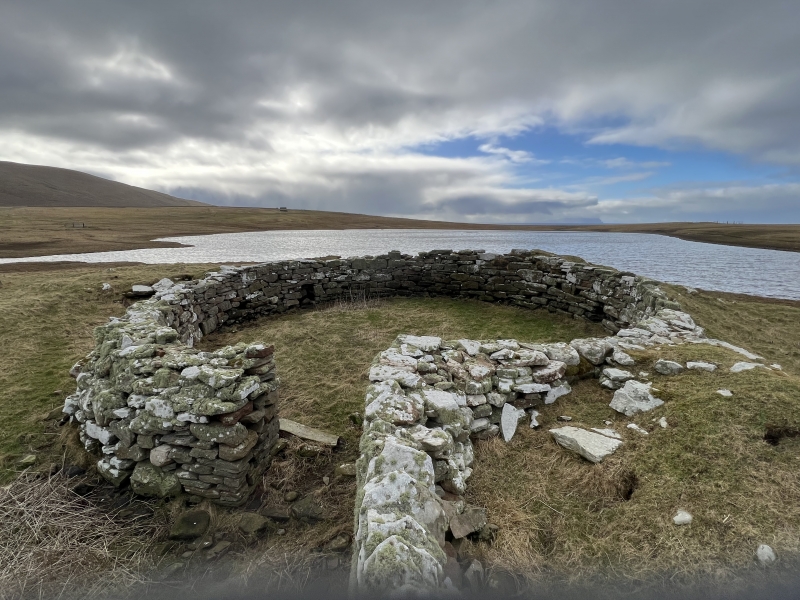
Entry Name: Loch of Huxter, broch
Scheduled Date: 21 June 1934
Last Amended: 30 March 2012
Source: Historic Environment Scotland
Source ID: SM2076
Schedule Class: Cultural
Category: Prehistoric domestic and defensive: broch
Location: Walls and Sandness
County: Shetland Islands
Electoral Ward: Shetland West
Traditional County: Shetland
The monument comprises the remains of an Iron Age broch, built probably between 500 BC and AD 200. The broch is visible as a grass-covered stony mound externally, but its interior has been cleared out and reused as a sheep pen with an entrance cut through the wall in the north. The interior is 10m in diameter with the inner wall standing up to 1.6m high. The broch is located at the NE end of the freshwater Loch of Huxter on enclosed and improved grazing land. Its coastal location affords extensive views over the West mainland and the North Atlantic. The monument was first scheduled in 1934, but the documentation does not meet modern standards: the present rescheduling rectifies this.
The area to be scheduled is circular on plan, measuring 50m in diameter, to include the remains described above and an area around them within which evidence relating to the monument's construction, use and abandonment may survive, as shown in red on the accompanying map. Specifically excluded from the scheduled area are the above-ground remains of the planticrub southeast of the broch, the stone boundary wall north of the broch, and the structural stonework associated with the damming of the Loch of Huxter, to allow for their maintenance.
Source: Historic Environment Scotland
Cultural Significance
The monument's cultural significance can be expressed as follows:
Intrinsic characteristics
Despite the later disturbance of the site (with some quarrying of material on the NW side and reuse of the interior as a sheep pen), the broch survives in reasonable condition. The structural footprint appears largely intact and the lower courses of the broch are sealed by later infill. Several architectural features are still visible, including the wall thickness, much of the internal wall face and traces of the outer wall; a mural cell and gallery space in the SE arc; and a low stone outwork in the southern arc. A rich artefact assemblage has been recorded from this site in the past, including querns, 'mallets', knives, pottery and bones. Despite later disturbances of the site, it is highly likely that earlier deposits, contemporary with the construction and original use of the broch, are likely to be preserved beneath the later uses. These and the standing remains have considerable potential to enhance our understanding of the use and function of the broch and the daily lives of the people who lived here. There is high potential for the recovery of further artefacts and ecofacts to help us understand more about the lives, economy and social status of the people and the extent to which this varied over time.
Later structures in the vicinity (a loch-side dam and sluice, field dykes, a nearby planticrub and a high boundary wall) may have incorporated stone quarried from the broch itself.
Contextual characteristics
This broch is one of over 130 known of in Shetland. They are a particularly distinctive type of Iron Age roundhouse structure and are likely to have served a variety of functions. While a domestic and agricultural function has been inferred from the evidence of excavated brochs elsewhere, researchers have also considered the symbolic and strategic significance of these buildings, their outworks and their position in the surrounding landscape. The broch at Loch of Huxter is similar in several respects to the surviving example at Clickhimin. Researchers have drawn parallels between the two based on their positions (both are sited next to a body of water), as well as the architectural similarities.
This example is particularly interesting because of the relative rarity of its mural feature: a gallery space leading in one direction only, with an expanded cell at the end. Researchers have suggested that this broch is neither particularly complex nor long-lived, which suggests it may have high potential to tell us about a specific phase during the several hundred years that brochs were in use, as well as provide further insight into more general issues such as the function(s), longevity and symbolism of brochs.
National Importance
This monument is of national importance because it has an inherent potential to make a significant addition to our understanding of the past, in particular of Iron Age Shetland and the role and function of brochs. The survival of structural and artefactual material from the broch's development can help us understand more about the lifestyles of the people occupying these monuments and something of their pattern of activity. Its loss would significantly diminish our future ability to appreciate and understand this class of monument and the wider Iron Age landscape of Scotland.
Source: Historic Environment Scotland
Bibliography
RCAHMS record the site as HU15NE 4. The Shetland Amenity Trust SMR records the site as MSN217.
References
Mackie, E W 2002, The roundhouses, brochs and wheelhouses of Atlantic Scotland c.700BC-AD500: architecture and material culture, Part 1: The Orkney and Shetland Isles. BAR British Series 342. Oxford, 58.
RCAHMS, 1946, The Royal Commission on the Ancient and Historical Monuments of Scotland. Twelfth report with an inventory of the ancient monuments of Orkney and Shetland, 3v Edinburgh, 146.
Source: Historic Environment Scotland
Other nearby scheduled monuments