Approximate Location Map
Large Map »
This site is entirely user-supported. See how you can help.
Latitude: 60.2009 / 60°12'3"N
Longitude: -1.2707 / 1°16'14"W
OS Eastings: 440533
OS Northings: 1146503
OS Grid: HU405465
Mapcode National: GBR R16S.4G2
Mapcode Global: XHD2Y.VVRQ
Entry Name: Wormadale Hill, standing stone 335m ENE of Kerith
Scheduled Date: 13 September 1960
Last Amended: 27 March 2012
Source: Historic Environment Scotland
Source ID: SM2048
Schedule Class: Cultural
Category: Prehistoric ritual and funerary: standing stone
Location: Tingwall
County: Shetland Islands
Electoral Ward: Shetland West
Traditional County: Shetland
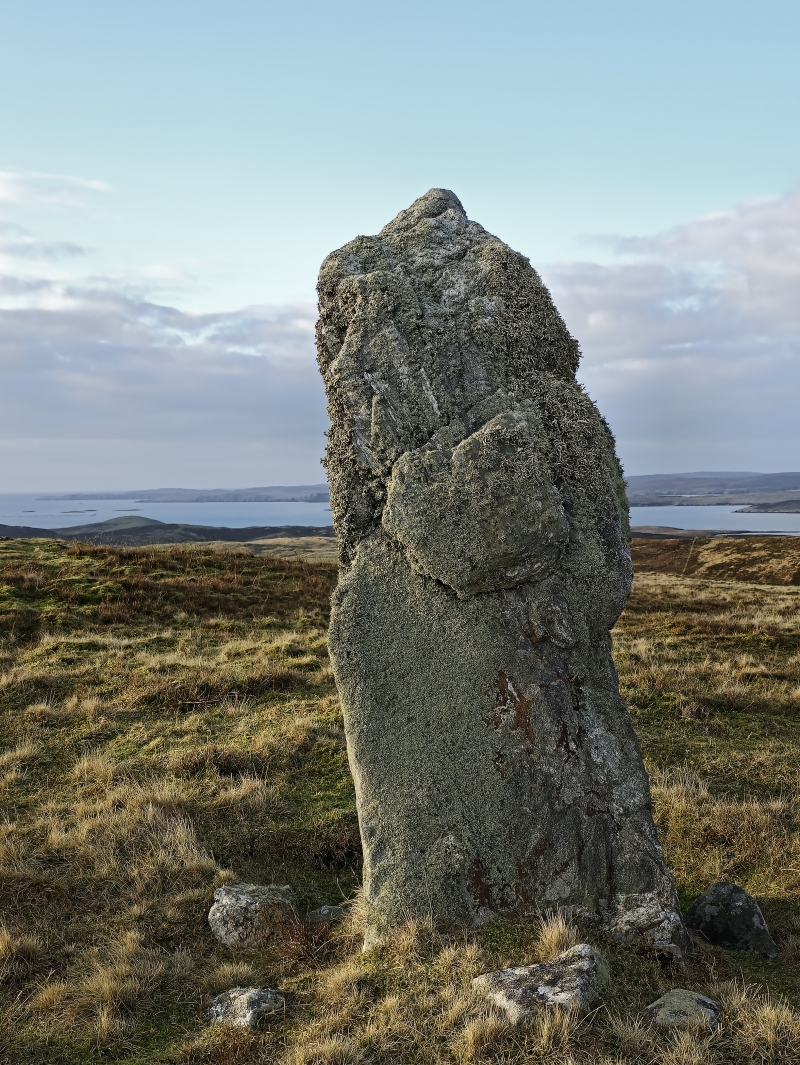
The monument comprises a standing stone likely to date to the third or second millennium BC. The stone stands approximately 2.4m high and is 0.6m in width (maximum) at its base. The granite monolith leans to the southwest and is approximately triangular on plan, tapering towards its top and with several quartz inclusions. Variously sized packing stones are visible around its base, indicating that evidence may survive for its date and method of erection. The standing stone is located on rough grazing land on the southern shoulder of Wormadale Hill, overlooking Whiteness Voe to the southwest, and at around 140m above sea level. The monument was first scheduled in 1960 but the documentation does not meet modern standards; the present rescheduling rectifies this.
The area to be scheduled is circular on plan, measuring 15m in diameter centred on the stone. The scheduling includes the remains described above and an area around them within which evidence relating to the monument's construction, use and abandonment may survive, as shown in red on the accompanying map.
Source: Historic Environment Scotland
Cultural Significance
The monument's cultural significance can be expressed as follows:
Intrinsic characteristics
The monument survives in good condition despite a gentle lean to the southwest. Several packing stones are visible at its base, helping to keep it in an upright position and indicating that the monolith was placed in a pit when first erected. This relatively undisturbed context suggests that archaeological deposits are likely to survive in buried horizons around and underneath its base. The lack of surviving monoliths in the immediate location suggests this was an isolated standing stone and not necessarily part of a larger monument. It may, however, have been incorporated into a wider landscape of contemporary sites.
Contextual characteristics
Standing stones are widespread in Scotland, which indicates the presence of prehistoric people across much of the country, stretching from the south and southwest to the Northern Isles. Individually, standing stones are often part of a much larger, wider system of monuments (such as henges, stone circles and cairns) and these often take advantage of natural routeways and vantage points. In this case, the views from the stone across its southern arc and over Whiteness Voe to the southwest are striking. Researchers have charted the alignment of standing stones with celestial bodies and events; a lunar alignment has been suggested at Wormadale. Researchers believe that standing stones such as this formed part of important ceremonial or religious events, for instance, the marking of changes in season or times in the agricultural year.
Like other, significant examples the effort required to transport and erect this monolith would have been substantial. This perhaps indicates something of the importance of the locale and of the stone itself, and its capacity to inform our understanding of the period. It may have the potential to further our knowledge of contemporary ceremonial and ritual landscapes.
National Importance
This monument is of national importance because it has an inherent potential to make a significant addition to the understanding of the past, in particular the ritual and ceremonial landscape of Shetland in the third or second millennium BC. Its loss would significantly impede our ability to understand the nature of earlier prehistoric ritual and ceremonial practice, as well as the wider beliefs of the prehistoric people that used these sites, both in Shetland and Scotland.
Source: Historic Environment Scotland
Bibliography
RCAHMS records the site as HU44NW 6.
References
RCAHMS, 1946 Twelfth Report with an Inventory of the Ancient Monuments of Orkney and Shetland. Edinburgh.
Thom. A and Thom. A S., 1978 Megalithic remains in Britain and Brittany. Oxford.
Source: Historic Environment Scotland
Other nearby scheduled monuments