Approximate Location Map
Large Map »
This site is entirely user-supported. See how you can help.
Latitude: 56.1522 / 56°9'7"N
Longitude: -5.1802 / 5°10'48"W
OS Eastings: 202570
OS Northings: 700055
OS Grid: NN025000
Mapcode National: GBR FDLG.7YP
Mapcode Global: WH1K0.DMHJ
Entry Name: Furnace, Ironworks
Scheduled Date: 16 November 1965
Last Amended: 8 November 2000
Source: Historic Environment Scotland
Source ID: SM2530
Schedule Class: Cultural
Category: Industrial: iron and steel
Location: Inveraray
County: Argyll and Bute
Electoral Ward: Mid Argyll
Traditional County: Argyllshire
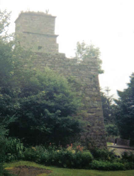
The monument comprises the remains of the iron works at Furnace, which sit within the village on the shore of Loch Fyne. The monument was first scheduled in 1965. On this occasion, an imprecise area was defined: the present rescheduling rectifies this.
The ironworks at Furnace was founded by the Duddon Co. from Cumbria in 1755, under a 57-year lease from the Duke of Argyll. The company was attracted by the plentiful supplies of charcoal to be found in Argyll. Production ceased in 1812 with the expiry of the lease. It is possible that several of the later alterations to the buildings relate to the Loch Fyne Powder Works, which were founded near by in 1841.
The remains of the ironworks consist principally of the furnace, a casting house, a three-storey blowing house, a large storage shed (now used as a coal-store), the traces of a lade and the remains of an enclosure, probably a reservoir, which has been recently demolished. The storage shed, lade and enclosure are not included within the scheduled area.
The furnace is a remarkably complete tapering square blast furnace, built of locally quarried granite incorporating many courses of roughly-squared blocks divided by small thick pinnings, set in lime mortar. It has retained its central hearth, built of light red sandstone, and brick lining which is intact, a unique survival. The ground floor of the furnace stack has two lintelled embrasures, one for the bellows and one for tapping off the molten metal into the casting house. These are formed with cast iron lintels, one of which is inscribed GF 1755, for Goatfield Furnace. Access from the terrace to the loading mouth was via a substantial stone-revetted ramp and the bridge loft on the upper floor of the blowing-house. The ground floor of the blowing house contained the bellows powered by a water wheel, fed from the lade. The casting house is a one-storey structure, now roofed with corrugated iron.
The area to be scheduled includes the furnace, the blowing house , the casting house and an area around it that has the potential for associated archaeology. The area is irregular in shape and has maximum dimensions of about 42m NNW-SSE and 37m NE-SW as marked in red on the attached map.
Source: Historic Environment Scotland
Bibliography
No Bibliography entries for this designation
Source: Historic Environment Scotland
Other nearby scheduled monuments