Approximate Location Map
Large Map »
This site is entirely user-supported. See how you can help.
Latitude: 57.3592 / 57°21'33"N
Longitude: -5.5555 / 5°33'19"W
OS Eastings: 186243
OS Northings: 835447
OS Grid: NG862354
Mapcode National: GBR D9N8.J1T
Mapcode Global: WH09W.M9Q6
Entry Name: Strome Castle
Scheduled Date: 24 January 2000
Source: Historic Environment Scotland
Source ID: SM8481
Schedule Class: Cultural
Category: Secular: castle
Location: Lochcarron
County: Highland
Electoral Ward: Wester Ross, Strathpeffer and Lochalsh
Traditional County: Ross-shire
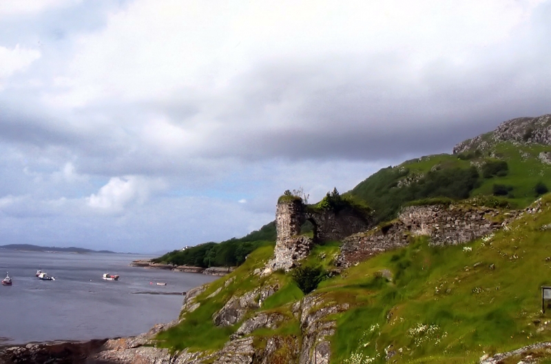
This monument consists of the remains of a castle consisting principally of a tower and a large hall.
Built by the MacDonalds of Glengarry in the 15th Century, the castle was always a source of dispute dominating the boundary between the MacDonalds in Lochcarron and Lochalsh and the MacKenzies in Kintail. Throughout the 16th Century the castle changed hands as the rivalry between the families continued to fester. The castle was besieged several times but was eventually blown up in 1602. It does not appear to have been reoccupied.
The strongly built tower appears to have taken the brunt of the explosion of 1602 and several large sections of masonry now lie a considerable distance from the tower. The adjoining hall is more easily discernible, not being covered by rubble. Recent excavations have confirmed that there are substantial undisturbed archaeological deposits within the castle.
The area to be protected includes the site of the castle, an area around it whose archaeology may retain information relating to the construction, use and destruction of the castle, and the location of fragments of masonry dislodged by the 1602 explosion. The area is defined to the W by the high water mark, to the N by the fence line, to the E by the retaining wall and modern steps and to the S by a line defined by the wall of the garden of Strome House.
The boundary features used to define the area are not to be included in the scheduling. The area is irregular in shape measuring about 80m N-S by 80m E-W at its greatest extremities. The area is marked in red on the accompanying map extract.
Source: Historic Environment Scotland
This monument is of national importance as the remains of a late medieval castle. It played an important role in the history of the area in the 15th and 16th centuries. It has been shown to have considerable archaeological potential to increase our knowledge of the construction, development and use of medieval castle in the West Highlands.
Source: Historic Environment Scotland
Bibliography
RCAHMS records the monument as NG 83 NE 25.
Source: Historic Environment Scotland
Other nearby scheduled monuments