Approximate Location Map
Large Map »
This site is entirely user-supported. See how you can help.
Latitude: 57.5005 / 57°30'1"N
Longitude: -3.9426 / 3°56'33"W
OS Eastings: 283685
OS Northings: 847253
OS Grid: NH836472
Mapcode National: GBR J8MW.YKT
Mapcode Global: WH4GF.DQTX
Entry Name: St Barevan's Church and Churchyard, Foxmoss Wood
Scheduled Date: 29 December 1971
Last Amended: 29 March 2001
Source: Historic Environment Scotland
Source ID: SM3116
Schedule Class: Cultural
Category: Crosses and carved stones: tombstone; Ecclesiastical: church
Location: Cawdor
County: Highland
Electoral Ward: Nairn and Cawdor
Traditional County: Nairnshire
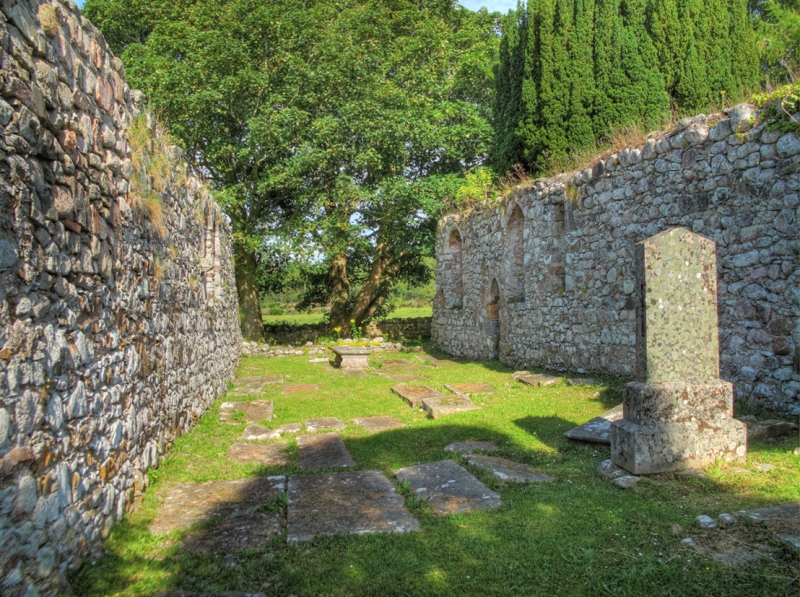
The monument consists of the remains of the St Barevan's Church and its burial ground. St Barevan's was the parish church of Barevan or Cawdor until it was superseded in 1619. The church was originally scheduled in 1971. On this occasion, an inadequate area was included to protect all of the archaeological remains: the present rescheduling rectifies this.
There is little known of the history of the church. The dedication to St Barevan (AD 500-550) and the existence of a quadrangular iron hand-bell at Cawdor Castle, supposedly from St Barevan's, suggests that it may have early Christian origins. Certain details of the building however, resemble those found at nearby Rait castle, and suggests that much of the fabric of the church dates from the late 13th/early 14th century.
The church measures approximately 21.5m E-W by 6m and is complete to near wall-head level on its N and S sides only. The E and W gables collapsed in the 19th century, but were reportedly crowstepped; architectural fragments lying beside the S wall of the church include a number of crowsteps. The walls are of well-coursed rubble with fine dressings in yellow and red sandstone.
The church is a single-chambered structure, although a plain freestone corbel appears to indicate the position of the rood screen, dividing off a chancel approximately 10m in length. There are no indications of windows in the nave, only the normal arrangement of N and S doors; the N door is now blocked, the S has a draw-bar hole, and both have lost their dressings. The chancel was well lit with two single lancet windows on the N side and one single lancet and one double lancet window on the S. The double lancet window is similar to that found at Rait Castle. The E end retains its piscina niche with a double bowl, although its arch and jambs have been robbed.
To the S and SW of the church are some late mediaeval grave-slabs, and, to the N of the church, a mediaeval stone coffin. In the 19th century it was reported that there were also at least a dozen cup-marked grave-slabs in the churchyard. These can no longer be identified.
The area to be scheduled includes the church and the old burial ground. It is defined by the boundary wall of the burial ground, which is excluded from the scheduling. The area is an irregular quadrangle with maximum dimensions of 50m from NW corner to SE corner, by 58 me transversely, as marked in red on the attached map. All modern burial lairs still in use are excluded from the scheduling
Source: Historic Environment Scotland
The monument is of national importance as an example of a relatively well-preserved late 13th/early 14th century parish church; as such it contributes to an understanding of medieval art, architecture, religious practices and material culture. The monument's importance is accentuated by its architectural details which associates it with the hall-house at Rait.
Source: Historic Environment Scotland
Bibliography
RCAHMS record the site as NH84NW 6.
References:
Bourke C 1984, 'The hand-bells of the early Scottish church', Proc Soc Antiq Scot, 113, 1983, 466, 467.
Dunbar J G 1966, The historic architecture of Scotland, London, 156.
Farrell S 1998, 'Inverness and Nairn Graveyard Survey (Cawdor; Nairn; Inverness & Bona parishes)', Discovery Excav Scot, 49.
Farrell S 1997, 'Inverness and Nairn Graveyard Survey (Ardclach; Croy & Dalcross; Daviot & Dunlichity; Moy & Dalarossie; Nairn; Urquhart & Glenmoriston parishes)', Discovery Excav Scot, 43.
Jolly W 1882, 'On cup-marked stones in the neighbourhood of Inverness; with an appendix on cup-marked stones in the Western Island', Proc Soc Antiq Scot, 16, 1881-2, 361-9.
Simpson W D 1937, 'Rait Castle and Barevan Church, Nairnshire', Proc Soc Antiq Scot, 71, 1936-7, 111-15.
Watson W J 1926, The history of the Celtic place-names of Scotland: being the Rhind lectures on archaeology (expanded) delivered in 1916, Edinburgh, 271.
Source: Historic Environment Scotland
Other nearby scheduled monuments