Approximate Location Map
Large Map »
This site is entirely user-supported. See how you can help.
Latitude: 57.4776 / 57°28'39"N
Longitude: -4.0992 / 4°5'57"W
OS Eastings: 274223
OS Northings: 844978
OS Grid: NH742449
Mapcode National: GBR J87Y.YWF
Mapcode Global: WH4GK.099Z
Entry Name: Culloden Battlefield, Graves of the Clans, Cairn and Well of the Dead
Scheduled Date: 30 June 1925
Last Amended: 8 September 2003
Source: Historic Environment Scotland
Source ID: SM967
Schedule Class: Cultural
Category: Secular: Culloden monuments
Location: Croy and Dalcross/Daviot and Dunlichity
County: Highland
Electoral Ward: Inverness South
Traditional County: Inverness-shire
The monument comprises the Graves of the Clans, the Memorial Cairn and the Well of the Dead, all on the Culloden battlefield. The elements of the monument are 18th and 19th century in date, relating to the battle itself and to commemoration of it. The elements of the monument are visible as earthworks and upstanding structures. The original scheduling is difficult to interpret on the modern map and excluded the area of the former road (now removed); this re-scheduling clarifies the scheduled area.
The Memorial Cairn, erected in 1881 by Duncan Forbes of Culloden, is c. 5m in diameter and 5m high, constructed of large boulders laid in mortar. One of the stones is inscribed and two plaques are attached. There are signs of cement-mortar repair. The top of the beehive-shaped cairn is overgrown with vegetation.
The grave markers around the site, also erected in 1881, commemorate the Scottish clans involved in the battle. Inscribed stones have not been erected at all of the identified graves. Geophysical survey in 2001 showed that there were graves in the area.
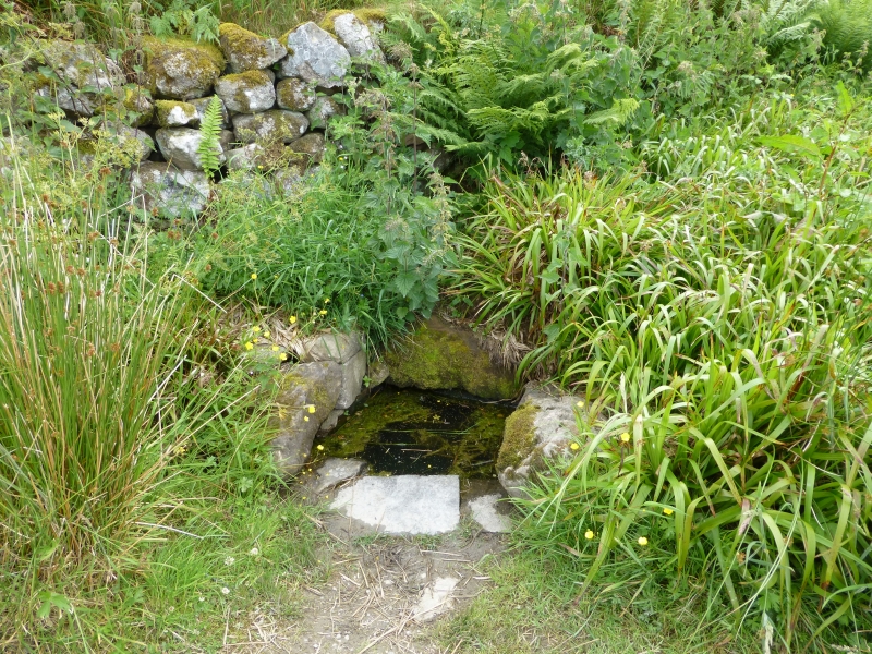
The Well of the Dead is located at the E end of the area. It is rectangular on plan, with dimensions of 0.52 by 0.54m, and is bounded on four sides by boulders and a dressed stone.
The area proposed for scheduling comprises the monument described above and an area around it within which related features are likely to survive. It is irregular on plan, with maximum dimensions of 205m ENE-WSE and 85m N-S, and excludes boundary dykes, modern fences and the top 10cm of any existing footpaths.
Source: Historic Environment Scotland
The monument is of national importance because of its place in the national consciousness, as the graves and memorials of the Jacobite army at the Battle of Culloden, a critical part of Scottish and British history. The graves also have an archaeological value.
Source: Historic Environment Scotland
Bibliography
The monument is recorded by the RCAHMS as Culloden Moor, The Graves of the Clans NH74NW 17.03, Culloden Moor, Well of the Dead NH74NW 20 and Culloden Moor, Battlefield NH74NW 17.00.
The Culloden Moor Memorial Cairn is listed as a Category-A Listed Building.
References:
Brander M 1975, SCOTTISH AND BORDER BATTLES AND BALLADS, 215-217.
Culloden Moor 1962, CULLODEN MOOR AND CLAVA CIRCLES, Edinburgh.
Denison S 1996, NEWS, Britsh Archaeology, 4.
Inverness Courier 1932, INVERNESS COURIER GUIDE TO INVERNESS, CULLODEN MOOR AND CLAVA CIRCLES: THE OFFICIAL GUIDE FOR THE 1932 INVERNESS ADVERTISING BOARD.
Inverness Courier 1939, INVERNESS, CULLODEN MOOR AND CLAVA CIRCLES: THE OFFICIAL GUIDE OF THE INVERNESS COURIER.
National Trust for Scotland, THE BATTLE OF CULLODEN 1747: PICTORIAL RECONSTRUCTION OF THE BATTLEFIELD TOGETHER WITH A SHORT ACCOUNT OF THE ACTION AND SOME DETAILS OF THE TWO ARMIES INVOLVED.
Neighbour T 1995, 'Culloden Battlefield (Inverness and Bona; Daviot and Dunlichty parishes), geophysical surveys', DISCOVERY EXCAV SCOT 39.
Ordnance Survey (Name Book), ORIGINAL NAME BOOKS OF THE ORDNANCE SURVEY, Book No. 18, 25-26.
Pollard T and Oliver N 2001, 'Culloden Battlefield (Croy and Dalcross; Daviot and Dunlichty parishes), geophysical surveys', DISCOVERY EXCAV SCOT Vol. 2, 52.
Pollard T and Oliver N 2002, TWO MEN IN A TRENCH: BATTLEFIELD ARCHAEOLOGY: THE KEY TO UNLOCKING THE PAST, 266-285.
Prebble J 1967, CULLODEN.
Prentice R 1967, THE NATIONAL TRUST FOR SCOTLAND GUIDE, 151-153.
RCAHMS 1979, THE ARCHAEOLOGICAL SITES AND MONUMENTS OF NORTH-EAST INVERNESS, INVERNESS DISTRICT, HIGHLAND REGION, The archaeological sites and monuments of Scotland series, Vol. 8, No. 242, 30, Edinburgh: Society of Antiquaries of Scotland.
Taylor I C 1996, CULLODEN: A GUIDEBOOK TO THE BATTLEFIELD WITH THE STORY OF THE BATTLE, THE EVENTS LEADING TO IT AND THE AFTERMATH.
Turner R 1994, 'Culloden Battlefield (Croy and Dalcross; Daviot and Dunlichty parishes), 18th-19th century dykes', DISCOVERY EXCAV SCOT 35.
Source: Historic Environment Scotland
Other nearby scheduled monuments