Approximate Location Map
Large Map »
This site is entirely user-supported. See how you can help.
Latitude: 55.1388 / 55°8'19"N
Longitude: -3.4551 / 3°27'18"W
OS Eastings: 307337
OS Northings: 583679
OS Grid: NY073836
Mapcode National: GBR 4990.SP
Mapcode Global: WH5WD.W3WC
Entry Name: Woody Castle, fort, Lochbank, Lochmaben
Scheduled Date: 30 April 1924
Last Amended: 2 November 1999
Source: Historic Environment Scotland
Source ID: SM665
Schedule Class: Cultural
Category: Prehistoric domestic and defensive: fort (includes hill and promontory fort)
Location: Lochmaben
County: Dumfries and Galloway
Electoral Ward: Annandale North
Traditional County: Dumfriesshire
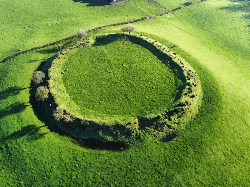
The monument comprises the remains of a fort of late prehistoric and possibly later date. It is already scheduled, but this extension expands the protected area to cover the full known extent of important remains.
The fort stands on a natural hillock overlooking Upper Loch and Mill Loch. Both lochs are much reduced from their former extent, and when built the fort would have been partly surrounded by water and marsh. The upstanding remains comprise the inner portion of a complex set of defences, the outer elements having been ploughed almost flat over the past century. The upstanding portion is a sub-circular enclosure about 60m across internally, edged by a massive rampart with a wide and deep outer ditch. The entrance has been on the ENE, and traces of a track or road leading to it from the E can be discerned on aerial photographs. Also now visible only on aerial photographs is an outer enclosure, roughly concentric with the fort on three sides but expanding on the NE. This appears to have had an entrance roughly in line with that of the inner defence, and to have consisted of a rampart of lesser proportions. On the SE this outer element appears to have either two ramparts or, more likely, two phases. The outer rampart survived as a partly upstanding feature until about 20 years ago.
Without excavation it is not possible to determine the sequence of this site. It may be purely prehistoric, but is more likely to be of several phases, a relatively simple prehistoric fort gradually modified and surrounded by more complex defences. The location not far from the motte and castle at Lochmaben, successive centres of Bruce family power in medieval times, suggests a possible origin as the fore-runner of this power centre.
The area to be scheduled is irregular on plan, and includes the upstanding remains and those now visible only on aerial photographs, as described above. It has maximum dimensions of 190m NNE-SSW by 150m NNW-SSE, bounded on the SSW by the edge of the public road and on the NNW partly by field boundaries. The above ground parts of all modern field boundaries are excluded from scheduling. The area now to be scheduled is marked in red on the accompanying map extract.
Source: Historic Environment Scotland
Bibliography
No Bibliography entries for this designation
Source: Historic Environment Scotland
Other nearby scheduled monuments