Approximate Location Map
Large Map »
This site is entirely user-supported. See how you can help.
Latitude: 59.0483 / 59°2'53"N
Longitude: -3.34 / 3°20'23"W
OS Eastings: 323223
OS Northings: 1018688
OS Grid: HY232186
Mapcode National: GBR L43T.JQ1
Mapcode Global: WH69F.NTRX
Entry Name: Skara Brae, settlement, mounds and other remains
Scheduled Date: 27 March 1928
Last Amended: 2 February 2004
Source: Historic Environment Scotland
Source ID: SM90276
Schedule Class: Cultural
Category: Prehistoric domestic and defensive: settlement; Prehistoric ritual and funerary: cist
Location: Sandwick
County: Orkney Islands
Electoral Ward: West Mainland
Traditional County: Orkney
This scheduling amalgamates and extends two existing schedulings. Its area covers the Neolithic village at Skara Brae, nearby remains of structures and activity areas of similar date, a large mound containing a succession of prehistoric and early medieval structures, and an area in which related remains are likely to survivve, including ancient soils and field systems.
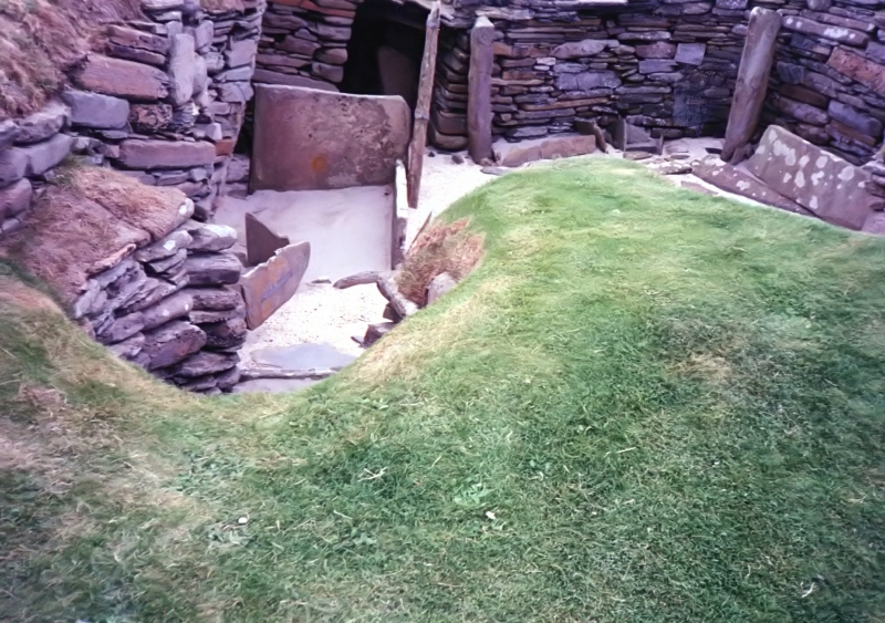
The remains covered by the scheduling include: the well-preserved village at Skara Brae with remains including walls, stone furniture, archaeological layers and a slaughtering floor partially revealed by excavation to its west; the large mound partially truncated by coastal erosion to reveal walls and burials some 150m to its west; together with prehistoric and medieval or later soils and other traces of ancient activities under the modern topsoil and sand to the west, south and east of Skara Brae. It includes a sand-covered tumulus SW of Voydale. It also includes a previously unscheduled area between dry land and the Mean Low Water Springs within which remains of ancient land survive, and a previously unscheduled area, including a mound on the NW raised bank of the stream north of Voydale, in which ancient soils and other remains will survive. It excludes the above-ground parts of all modern buildings, field walls and fences above ground level, and the upper levels of all modern built paths.
The area to be scheduled extends from west to east from the SW corner of Skaill Bay to the fence running NW by SE to the north of the stream or lade north of Voydale, and from north to south from the Mean Low Water Springs to the farm road west of Skaill, measuring a maximum of 582m from its easternmost to its westernmost point, and 370m from its northernmost to its southernmost point, as outlined in red on the attached map.
Source: Historic Environment Scotland
The monument is of national importance because it includes a remarkably well preserved neolithic settlement and associated remains, in addition to the remains of later periods. These remains, part of which are designated a World Heritage Site, have the potential to provide high-quality evidence for settlement, burial and environment from the early prehistoric to Viking and later periods.
Source: Historic Environment Scotland
Bibliography
Skara Brae and related sites in its immediate vicinity.
RCAHMS records: HY21NW 12.00, HY21NW 12.01, HY21NW 12.02, HY21NW 12.03, HY21NW 13, HY21NW 16, HY21NW 30.02, HY21NW 30.00, HY21NW 30.02, HY21NW 30.01, HY21NW 39, HY21NW 41.
References:
Childe V G and Paterson J W 1929, 'Provisional report on the excavations at Skara Brae, and on finds from the 1927 and 1928 campaigns', PROC SOC ANTIQ SCOT, Vol. 63,
225-80.
Childe V G 1930a, 'Operations at Skara Brae during 1929' PROC SOC ANTIQ SCOT, Vol. 64.
Childe V G 1931a, 'Final report on the operations at Skara Brae', PROC SOC ANTIQ SCOT, Vol. 65.
Childe V G, 1950a, ANCIENT DWELLINGS AT SKARA BRAE, ORKNEY, Edinburgh.
Clarke D and Maguire P 1996, SKARA BRAE, Historic Scotland guidebook.
RCAHMS 1946, TWELFTH REPORT WITH AN INVENTORY OF THE ANCIENT MONUMENTS OF ORKNEY AND SHETLAND, 3v Edinburgh: HMSO, 254-9, No. 683.
Clarke D V 1976a, THE NEOLITHIC VILLAGE AT SKARA BRAE, ORKNEY: 1972-3 EXCAVATIONS: AN INTERIM REPORT, Edinburgh.
Historic Environment Scotland Properties
Skara Brae
https://www.historicenvironment.scot/visit-a-place/places/skara-brae
Find out more
Source: Historic Environment Scotland
Other nearby scheduled monuments