Approximate Location Map
Large Map »
This site is entirely user-supported. See how you can help.
Latitude: 54.9743 / 54°58'27"N
Longitude: -3.5242 / 3°31'27"W
OS Eastings: 302533
OS Northings: 565468
OS Grid: NY025654
Mapcode National: GBR 3BTX.TN
Mapcode Global: WH5X4.T7ZH
Entry Name: Caerlaverock Castle and Old Castle,castles,courtyards and harbour
Scheduled Date: 24 January 1995
Source: Historic Environment Scotland
Source ID: SM90046
Schedule Class: Cultural
Category: Secular: castle
Location: Caerlaverock
County: Dumfries and Galloway
Electoral Ward: Nith
Traditional County: Dumfriesshire
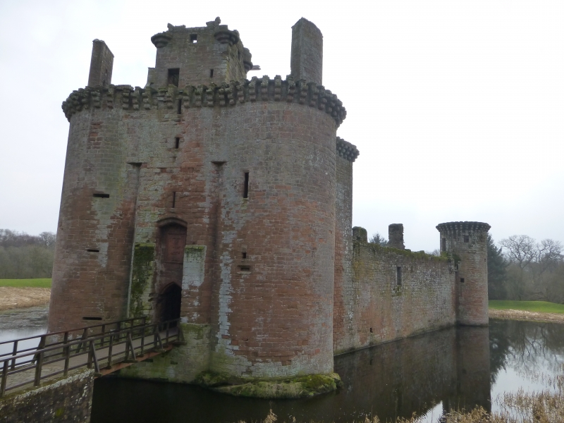
The monument consists of the two castles of Caerlaverock, the old and the new, along with the surviving earthworks associated with the two buildings and the site of the harbour associated with the old castle.
Caerlaverock Castle was the stronghold of the Maxwells, wardens of the West March in the later Middle Ages. The first castle was built by them in about 1220. It is lozenge-shaped on plan and sits on a low mound surrounded by a silted-up moated ditch. It was stone built, possibly supported on oak piles. It is flanked by extensive banks and ditches of enclosures or yards to the SW and NE. The site of its harbour lies to the SW, in woods between the old castle and the present edge of the River Solway.
The old castle was abandoned about 1270, when the present castle was erected. The new castle is an archetype of a medieval stronghold, with its water filled ditch crossed by a bridge leading to a heavily defended gatehouse and into the inner court of the castle. It is approached from the NE, through a round-arched gate of stone set in the boundary of the outer court, now defined by a low bank. The castle's triangular plan is unique in Scotland, and is dominated, at the N apex, by the entrance, a double round-towered gatehouse, which provided the lordly lodging. The curtain wall which forms the triangle is provided with a round tower at each of the two remaining angles. A range of stone buildings was built against each of the curtain walls. The W range dates from the 15th century and the fine Nithsdale Lodging was built against the S and E walls in 1634.
Caerlaverock was abandoned after a seige in 1640 which badly shattered the castle and left it a ruin.
The area to be scheduled measures a maximum of 920m NS by 590m EW, to include both castles and their outer courtyards as well as the remains of the harbour associated with the first castle. The area is outlined in red on the accompanying map. Modern field boundaries are excluded.
(NB Caerlaverock Old Castle was formerly index no. 90047)
Source: Historic Environment Scotland
Bibliography
No Bibliography entries for this designation
Historic Environment Scotland Properties
Caerlaverock Castle
https://www.historicenvironment.scot/visit-a-place/places/caerlaverock-castle
Find out more
Source: Historic Environment Scotland
Other nearby scheduled monuments