Approximate Location Map
Large Map »
This site is entirely user-supported. See how you can help.
Latitude: 55.7734 / 55°46'24"N
Longitude: -4.3909 / 4°23'27"W
OS Eastings: 250120
OS Northings: 655933
OS Grid: NS501559
Mapcode National: GBR 3L.9BWZ
Mapcode Global: WH3PL.J49V
Entry Name: Duncarnock, fort
Scheduled Date: 25 November 1981
Source: Historic Environment Scotland
Source ID: SM4339
Schedule Class: Cultural
Category: Prehistoric domestic and defensive: fort (includes hill and promontory fort)
Location: Mearns
County: East Renfrewshire
Electoral Ward: Newton Mearns North and Neilston
Traditional County: Renfrewshire
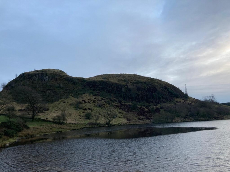
The monument comprises the remains of a fort probably occupied in later prehistory between 1200 BC and AD 400 and perhaps reused between AD 400 and AD 700. The fort occupies a broad hilltop with a rocky knoll at the NE end. A single terraced rampart of earth and stone extends around the crest of the hill and an inner defence may have provided additional protection for the knoll. The sides of the hill are extremely steep, particularly to the north-west where cliffs descend to the reservoir below. The site lies at approximately 200m above sea level and gives extensive views over the surrounding landscape.
The fort interior measures around 192m NE-SW by 100m transversely, the higher knoll at the NE end measuring around 34m x 24m transversely. A wide terrace extends along the front of the S rampart, which was originally around 3m wide. The rampart encloses around 2 ha (5 acres) of ground. A field bank crosses the SW corner of the fort, breaking where it intercepts the earlier fort rampart.
The scheduled area is shown in red on the accompanying map.
Description added on 24 November 2011
Source: Historic Environment Scotland
Cultural Significance
The monument's cultural significance can be expressed as follows:
Intrinsic characteristics
This monument represents a later prehistoric defended settlement with good evidence for a single earth and stone rampart. Evidence for additional defences protecting the higher knoll to the NE is more tentative. Researchers have found no evidence for ditches associated with any of the ramparts and the defences are relatively small scale, although they make good use of the natural slopes of the hill. The hilltop setting and ramparts suggest defensive concerns were among the factors in the choice of site, although doubt remains as to exactly how defensible the site would have been. In addition to the upstanding remains, there is potential for complex archaeological remains of the defences to survive below ground. These remains can help us to understand more about the construction, use and abandonment of the defensive structures, helping to inform our understanding of the character of late prehistoric defended settlement in this area. Internal dwellings have not been recorded but the fort's situation on marginal unimproved land suggests that levels of preservation will be excellent. Buried archaeological remains may thus also exist within the interior and have the potential to provide evidence for the design, construction, phasing and use of buildings. Potential also exists for the survival of buried land surfaces beneath the rampart and other standing features. These could preserve information about the environment before the site was constructed, adding to the time-depth represented by the remains. Cut features such as post-holes and pits may contain archaeologically significant deposits, including artefacts and ecofacts, that can further our understanding of society, ritual, economy, agriculture and potentially domestic architecture. Researchers working in 1958 recovered a sherd of coarse pottery, perhaps of late prehistoric date, together with a fragment of worked shale.
Contextual characteristics
Defended settlements and forts were built at various times from the late Bronze Age (starting around 1200 BC) until probably the end of the early Middle Ages (around 1000 AD). Although excavation indicates that the first defensive systems appeared in the Bronze Age, the majority of monuments excavated so far have produced evidence for Iron-Age occupation, ranging from the mid- to late 1st millennium BC.
Researchers have identified relatively few defended settlements in the former country of Renfrewshire compared to other areas of Scotland. The known sites range from small settlements, often known as 'homesteads' and measuring less than around 50m in diameter, to larger forts. Most are characterised by relatively small-scale defences, typically stone banks or walls built on or near to hilltops to enhance the natural relief. Homesteads such as Knockmade Hill and Knapps may have been occupied in the late Bronze Age and excavation at the latter produced evidence of a wooden palisade, erected early in the history of the site. Larger settlements also have the potential to originate at a relatively early date and the hillfort at Craigmarloch has produced evidence for a palisade that predated a timber-laced rampart and may date to around 800 BC. Both small homesteads and larger hillforts appear to have continued in use through much of the late 1st millennium BC. Researchers have interpreted the hillforts as suggesting the emergence of small tribal units and the hillfort at Walls, the largest hillfort in former Renfrewshire, may have had such a function. This monument has not yet been excavated and there is much to learn about its precise function. Nevertheless, its high archaeological potential means that it has particular ability to contribute towards a better understanding of prehistoric forts and defended settlements in this area, particularly those in elevated positions. Their construction and layout including size, number of entrances, design and placement in the landscape are all important in understanding this type of monument. By comparing this monument to others of its type we can learn more about defended settlements and associated dwellings in the former county of Renfrewshire and more widely across Scotland.
Associative characteristics
The hilltop is labelled 'Duncarnock' on the 19th century OS 1st edition map. It is also known locally as the 'Craig of Carnock'.
National Importance
The monument is of national importance because it has an inherent potential to make a significant addition to the understanding of the past, in particular the study of forts and defended settlements in later prehistoric SW Scotland. It survives in good condition above ground and it is probable that extensive and complex archaeological remains exist below the surface relating to the construction and use of the ramparts and potential internal features. There is high potential for survival of buried material including artefacts and ecofacts that relate to the use or abandonment of the fort. The monument has the potential to tell us about wider prehistoric society, how people lived, where they came from and who they had contacts with. Its importance is increased by existence in the region of other monuments of potentially contemporary date and the capacity it therefore has to inform us about the nature of relationships between monuments of similar function. Spatial analysis of sites may inform our understanding of patterns of landholding and the expansion of settlement. Its loss or diminution would impede our ability to understand the placing of such monuments within the landscape both in the former county of Renfrewshire and in other parts of Scotland, as well as our knowledge of later prehistoric social structure and economy.
Statement added on 24 November 2011
Source: Historic Environment Scotland
Bibliography
RCAHMS record the site as NS55NW 3. The WoSAS SMR records the site as WoSASPIN 8375.
References
Alexander, D (ed) 1996, Prehistoric Renfrewshire; Papers in Honour of Frank Newall, Renfrewshire Local History Forum.
Alexander, D 2000, 'Later prehistoric settlement in west central Scotland' in Harding, J and Johnston, R, Northern Pasts; Interpretations of the Later Prehistory of Northern England and Southern Scotland, BAR Brit Ser 302, Oxford: Archaeopress
Details added on 24 November 2011
Source: Historic Environment Scotland
Other nearby scheduled monuments