Approximate Location Map
Large Map »
This site is entirely user-supported. See how you can help.
Latitude: 56.4535 / 56°27'12"N
Longitude: -6.972 / 6°58'19"W
OS Eastings: 93789
OS Northings: 740129
OS Grid: NL937401
Mapcode National: GBR 9C5N.HCZ
Mapcode Global: WGW93.W16Z
Entry Name: St Patrick's Chapel, Ceann a' Mhara, Tiree
Scheduled Date: 19 November 1997
Source: Historic Environment Scotland
Source ID: SM6905
Schedule Class: Cultural
Category: Ecclesiastical: chapel
Location: Tiree
County: Argyll and Bute
Electoral Ward: Oban South and the Isles
Traditional County: Argyllshire
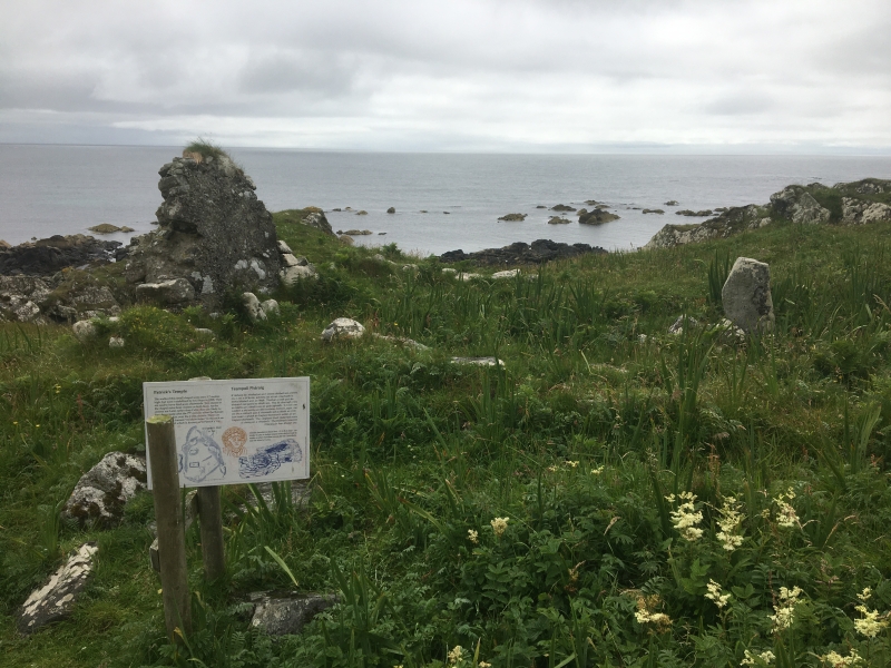
The monument consists of an enclosure containing the remains of a chapel, which may have originated as an Early Christian monastic site. The site lies on the W shore of Balephuil Bay and approximately 900m S of Beinn Ceann a' Mhara.
The enclosure walls follow the 2 rocky ridges which bound the site on the E and SW sides. The site is limited by a rock escarpment to the NW and is open to the shore to the SE. Traces of the enclosure wall can be seen on the crests of the ridges, and one of the better-preserved sections measures over 1m wide, faced on the outer side with massive stones of dry-stone construction. Towards the S end of the E wall is a gap which may have formed an entrance about 1m wide.
The chapel, which is of lime-mortared construction and of medieval date, stands near the SW corner of the enclosure and is now very ruinous. It measures 8.08m E-W by 3.4m N-S within walls varying between 0.8m and 0.9m thick. Part of the E gable survives to a height of 1.8m above existing ground level, but the remaining walls are reduced to turf-covered footings. The footings of an altar-base survive against the E wall, and towards the W end of the N wall is a gap, possibly representing an entrance. The structure of the chapel obviously post-dates any Early Christian use of the site.
Close to the N and E sides of the enclosure are several scarped platforms associated with slight remains of rubble walls, probably representing small huts of circular or sub-rectangular plan. There are more substantial remains of a sub-rectangular building 7m to the N of the chapel, measuring approximately 6m E-W by approximately 2.7m N-S within drystone rubble walls 0.9m in average thickness. The angles of the building are noticeably rounded.
Within the chapel are 2 cross-incised boulders, each bearing an incised Latin cross on both sides. 8m to the SE of the E end of the chapel is a further boulder with a single incised Latin cross. There appear to have been burials in the area around the chapel, and the boulders may originally have marked these.
The site is thought to have formed a cashel or monastery of the Early Christian period, although the remains of the enclosure wall are less substantial than in other such sites. It may have been associated with the probable Early Christian monastic site at Soroby, possibly as a retreat. Nearby placename evidence suggests that there was an ecclesiastical use of the site while the Norse language was still spoken in the area. This continued with the erection of the chapel later during the Middle Ages, although nothing definite is known of the site's history save the dedication to St Patrick.
The area to be scheduled is irregular in shape, measuring a maximum of 135m N-S by a maximum of 85m E-W, as shown in red on the accompanying map. It includes the whole of the monastic enclosure, including the chapel and the cross-incised boulders, together with an area in which evidence for the construction, development and use of the site may survive.
Source: Historic Environment Scotland
The monument is of national importance as the likely remains of an Early Christian monastic site, which continued in ecclesiastical use later in the Middle Ages with the building of a chapel. It has the potential to provide evidence relating to the organisation of the early and medieval church in Scotland, early historic and medieval ecclesiastical architecture and to the nature of society and continuity of land-ownership in the Norse period and early Middle Ages.
Source: Historic Environment Scotland
Bibliography
Reference:
RCAHMS, Argyll 3, No. 325.
Source: Historic Environment Scotland
Other nearby scheduled monuments