Approximate Location Map
Large Map »
This site is entirely user-supported. See how you can help.
Latitude: 56.1909 / 56°11'27"N
Longitude: -4.3128 / 4°18'45"W
OS Eastings: 256579
OS Northings: 702221
OS Grid: NN565022
Mapcode National: GBR 0X.FWN8
Mapcode Global: WH3MH.QNH9
Entry Name: Nether Glenny, cup and ring marked rocks 700m NW and 700m WNW of
Scheduled Date: 30 September 1997
Last Amended: 3 March 1999
Source: Historic Environment Scotland
Source ID: SM6959
Schedule Class: Cultural
Category: Prehistoric ritual and funerary: cupmarks or cup-and-ring marks and similar rock art
Location: Port Of Menteith
County: Stirling
Electoral Ward: Trossachs and Teith
Traditional County: Perthshire
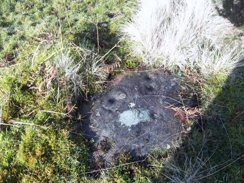
The monument comprises two cup-marked rocks of prehistoric date. The monument was first scheduled in 1997, but a recent detailed survey of the area has shown that the area scheduled was inaccurate. The present rescheduling rectifies this.
The monument lies in rough pasture overlooking the valley of the Glenny Burn and with outlooks over the Lake of Menteith to the S. It comprises two earthfast boulders decorated with carved cup-marks.
Cup-marks are decorative circular depressions carved into standing stones, outcrops of bedrock and boulders, and are sometimes found arranged in patterns with other motifs. They are thought to date principally to the Bronze Age and to have been related to acts of ritual and religious significance.
The area to be scheduled encompasses the two cup-marked rocks and areas around them in which associated archaeological deposits may be expected to survive. It is divided into two circular areas, each 35m in diameter, as marked in red on the accompanying map extract.
Source: Historic Environment Scotland
The monument is of national importance because of its potential to contribute to our understanding of prehistoric ritual practices.
Source: Historic Environment Scotland
Bibliography
RCAHMS records the monument as NN 50 SE 19.
Source: Historic Environment Scotland
Other nearby scheduled monuments