Approximate Location Map
Large Map »
This site is entirely user-supported. See how you can help.
Latitude: 50.5533 / 50°33'11"N
Longitude: -2.421 / 2°25'15"W
OS Eastings: 370269.480676
OS Northings: 72698.273396
OS Grid: SY702726
Mapcode National: GBR PZ.P68T
Mapcode Global: FRA 57TL.NNQ
Entry Name: East Weare rifle range
Scheduled Date: 28 October 2015
Source: Historic England
Source ID: 1428958
County: Dorset
Civil Parish: Portland
Built-Up Area: Grove
Traditional County: Dorset
Lieutenancy Area (Ceremonial County): Dorset
Church of England Parish: Portland All Saints
Church of England Diocese: Salisbury
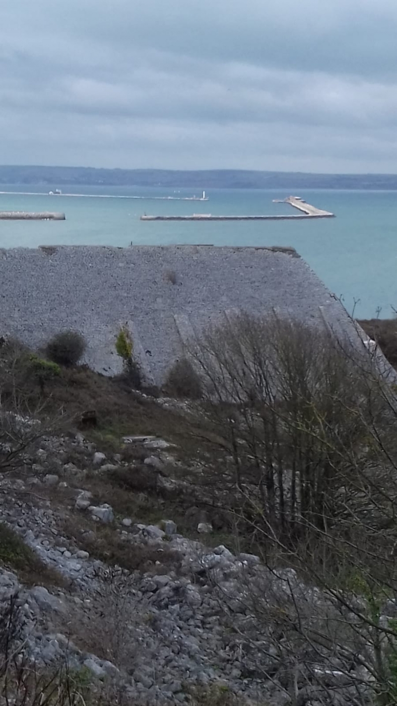
Late-C19/early-C20 rifle range located on the north-east side of the Isle of Portland and is orientated on a south-east to north-west axis. From the south-east it comprises the stop butt, the marker’s gallery and target housing, and the 100 yard firing position.
Source: Historic England
Principal elements
The late-C19/early-C20 rifle range is located on the north-east side of the Isle of Portland and is orientated on a south-east to north-west axis. From the south-east it comprises the stop butt, the marker’s gallery and target housing, and the 100 yard firing position.
Description
Stop butt: a linear structure which has an angled extension to its west side. The main part of the butt measures approximately 210ft (64m) long, 112ft (34m) wide and up to 66ft (20m) high. The structure has an earth and stone core and its sloping south and east sides are faced with Portland stone, with ashlar quoins. On the south face are eight sloping buttresses faced with masonry. There are three buttresses on the east face. The turf on the north face has been removed to reveal the stepped, rough stone structure beneath. Along the top of the butt the concrete coping into which was set a line of wooden planks has been removed. The angled west end is largely obscured by vegetation (2015) but has sloping masonry similar to the rest of the butt with no buttresses. The top is grassed over.
The marker’s gallery and target housing: approximately 98ft (30m) to the north-west of the stop butt is the earthwork structure containing the marker’s gallery and target mechanisms. The sloping north face of the earthwork is covered in turf and has a flat top before rising up again to cover the marker’s gallery. The dog-legged east side has sloping drystone masonry with ashlar quoins, similar in character to that of the stop butt. The sloping masonry on the south side has been buried by the infilling of the area between the target housing and the stop butt. There are traces of drystone masonry on the west face. The marker’s gallery comprises a sloping brick wall to the north which is built into the earth bank behind, and a flat, corrugated iron roof covered in concrete which is supported by a horizontal steel I-beam with a steel rail above, and originally held up by 13 cast-iron pillars marked W H Baker Portland. Several of these have been replaced by welded steel supports. Fixed to the brick wall are seven plywood seats on angled iron frames, and ten cast-iron rings. Midway along the gallery remains the west wall of an inserted wooden hut. Attached to its outer face is a rack for ten rifles. To its rear wall is a corner telephone shelf. The east wall has been removed. There are traces of another wooden hut at the east end but this appears to have been removed prior to the construction of the single-skin brick wall that blocks the east end. The floor of the marker’s gallery is concrete with a Portland stone kerb. Along its length runs a rectangular, concrete well which contains the seven target frames. The target-lifting mechanisms are of tubular steel, suggesting that they are early to mid-C20, and comprise a braced rectangular steel frame fixed into the well and secured by a strut to the roof. Two rectangular frames, one to the front and one to the rear, are linked by steel hawsers running over pulley wheels at each end of the structure. To the south of the target frames is a wooden plank screen. At the west end of the marker’s gallery are the remains of a former target store.
100 yard firing position: approximately 128ft (39m) long, 75ft (23m) wide and up to 13ft (4m) high, it is a large earthwork with sloping masonry to all four elevations; the turf that originally covered the north elevation has been removed. There is a flight of concrete steps at the west end giving access to the gravel-covered surface along the top of the earthwork. There is a joint in the stonework near the east end suggesting that it has been extended eastwards. Much of the stone at the east end has slumped and collapsed.
Exclusions
All telegraph poles and fence posts are excluded from the scheduling although the ground beneath these features is included.
Source: Historic England
The stop butt, marker’s gallery and target housing, and the 100 yard firing position at East Weare rifle range are scheduled for the following principal reasons:
* Survival: as a good and substantially intact example of a late-C19/early-C20 rifle range;
* Potential: the site will contribute to our understanding of the operation of this particular rifle range and the provision of military training in this period more generally;
* Rarity: a significant example of an increasingly rare asset type;
* Group value: forms part of a significant group of designated military structures on the Isle of Portland and contributes to our understanding of the military development of East Weare and its importance as a strategic location.
Source: Historic England
Other
Dorset Historic Environment Record, 'East Weare Rifle Range, Portland Port, Portland', Monument No: 4001270
Terrain Archaeology, 'East Weares Rifle Range, Portland Port, Portland, Dorset. English Heritage (RCHME) Level 2 Survey (April 2000)
Source: Historic England
Other nearby scheduled monuments