Approximate Location Map
Large Map »
This site is entirely user-supported. See how you can help.
Latitude: 52.7161 / 52°42'58"N
Longitude: 1.4691 / 1°28'8"E
OS Eastings: 634399.9524
OS Northings: 318809.6761
OS Grid: TG343188
Mapcode National: GBR XJ5.L8C
Mapcode Global: WHMT4.JZSM
Entry Name: RAF Neatishead Type 84 radar modulator building and four radar plinths
Scheduled Date: 27 February 2008
Source: Historic England
Source ID: 1021408
English Heritage Legacy ID: 36331
County: Norfolk
Civil Parish: Neatishead
Traditional County: Norfolk
Lieutenancy Area (Ceremonial County): Norfolk
Church of England Parish: Neatishead St Peter
Church of England Diocese: Norwich
The monument includes the above ground remains of the Type 84 radar and
modulator building and four radar plinths, in five separate areas of
protection. These are some of the key surviving elements of RAF Neatishead
radar station which opened in 1941 and has the distinction of being the
longest continuously occupied radar station in Britain, and probably the
world. Other structures on the station have been recommended separately for
designation by listing.
The station opened in June 1941 as a Ground Control Intercept (GCI) Station
and its development was typical of many stations of this type. GCI stations
were developed from late 1940 to assist in the tracking and interception of
hostile aircraft after they crossed the coast, particularly at night. The
original Chain Home radar system was strung out along the coast and the
tracks of enemy aircraft were lost as they headed inland. GCI stations were
designed to counter this problem by tracking hostile aircraft as they passed
inland and directing the local fighter squadrons to attack the intruders.
Typical of a first phase GCI radar station, RAF Neatishead comprised mobile
caravans and wooden guard house all surrounded by a perimeter fence;
accommodation huts were added later. The second phase of building activity
began in January 1942, when a timber operations hut (which survives in
modified form, in use until recently as a dental and medical centre), a
timber 'goalpost' gantry (to support a Type-8 radar) and other ancillary
structures were built. This phase is known as an 'Intermediate GCI Station'.
This was quickly followed by construction work for the last wartime phase,
the Fixed or 'Final' GCI Station. Neatishead was one of 21 Final GCI
Stations, and one of only 12 to be fully equipped with searchlight and
fighter control. The main feature of this phase was the double storey,
protected Operations Room or 'Happidrome', which was completed on 15 July
1942 (later refurbished as the R30). Adjacent to it was a standby generator
building. The station became operational in its final wartime form in
January 1943 with a Type-7 surveillance radar giving it cover to 90 miles
(149km) and up to 70,000ft (21,336m), linked to it were Type-13 radars which
provided information on target heights.
Neatishead was retained after the end of the war and as a result of the
Cherry Report (an examination of Britain's post-war air defence
requirements), it was recommended that the Sector Operations Centres should
be combined with a number of GCI stations. Alterations to accommodate this,
including the extension of the wartime 'Happidrome', began at Neatishead in
December 1948 and were completed by October 1950. In the early 1950s
Neatishead was equipped with the following radar: Type-7 Mark II
surveillance radar, Type-11 Mark II, two Type-14 centrimetric search radars,
and five Type-13 height finding radars.
In the early 1950s, as part of the Rotor scheme to refurbish Britain's radar
defences, an R3 double level sunken bunker, which was entered through a
'bungalow' guardroom, was built. And on the surface new protected radar
plinths were constructed (36331/02-05). Some distance away from the site, in
Neatishead village, a standby generator building, designed to resemble a
church, was built. By the late 1950s, as a result of a change in defence
policy, the emphasis was moved to the nuclear deterrent to ensure Britain's
security. The air defences were scaled down under a project to protect the
nuclear deterrent bases and to give adequate warning of a hostile attack to
allow the retaliatory strike to be launched, after which there would be
little need for air defence, the so called 'Tripwire Response'. The scheme
to reconfigure Britain's radar defences, both to respond to the new strategic
demands and new technology was known as 'Linesman'. Neatishead was just one
of four stations where major rebuilding working took place as part of this
scheme. Structures built in the early 1960s include the Type-84 and R17
modulator building (36331/01), the Type-85 radar and R12 bunker to house its
processing equipment, High Speed Aerials, HF 200 height finders and a new
generator building. A major set back occurred in 1966 when the refurbished
R3 bunker was gutted by fire, with some loss of life. The radars, however,
continued in use sending their data to remote sites. Neatishead regained its
operational role again in 1972 when the Standby Early Warning and Control
(SLEWC) centre was established in the wartime Happidrome, now restyled the
R30.
But by the time the Linesman system was fully operational in the 1970s, NATO
policy had moved to one of 'Flexible Response', whereby the reaction to any
Soviet aggression would not immediately be met with massive nuclear
retaliation, but might begin with a conventional phase to allow time for
negotiation. The infrastructure of Linesman with its few static sites was
clearly very vulnerable to destruction in a pre-emptive strike. The system
designed to replace Linesman was known as Improved United Kingdom Ground
Defence Environment (IUKADGE). In place of fixed radar new mobile systems
were developed which used sophisticated electronics to counter jamming in
place of the massive power input required by the earlier system. These were
supplemented by the use of inputs from air and seaborne radars and the
operations centres were provided with refurbished hardened bunkers,
exemplified in the R3 bunker at Neatishead. This system finally became fully
operational in 1992.
Subsequent to the end of the Cold War, more concern has been given to the
working environment on the station; a new combined mess was constructed in
the early 1990s and in 1999 the redundant standby generator building was
demolished. In common with other radar stations ornamental tree planting
enhances its surroundings. Neatishead is home to the RAF's Air Defence Radar
Museum, which is housed in the wartime Happidrome (R30) and is open to the
public.
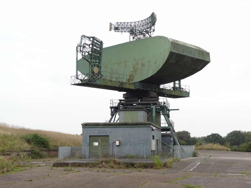
The Type 84 radar and R17 modulator building (36331/01) is located on the
north side of the R3 bunker towards the north-west corner of the station. A
Type-80 radar was originally mounted over the R17 modulator building, but
this had been replaced by the Type-84 by 1963. The radar comprises a pair of
back to back 75ft (18.28m) x 25ft (6.23m) parabolic reflector dishes mounted
on a horizontal girder. At either end of the girder are steel frameworks for
mounting eight L-band hornfeeds that transmitted and received the radar
beams. Only one stack of hornfeeds was installed and this remains in
position. An Identification Friend or Foe (IFF) aerial is placed above the
reflector dishes. IFF was an electronics system which elicited coded reply
signals from suitably equipped aircraft. The cabin immediately below the
horizontal beam housed the turning gear. The radar array is supported on a
steel gantry which sits over the single storey flat roofed modulator
building.
The modulator building measures approximately 29m east-west by 10m
north-south at its greatest extent and is constructed in reinforced concrete.
The part of the building immediately beneath the radar housed the DC supply
rectifiers to convert alternating electrical current to direct current and
the switch and control room. Apparatus to ensure that the radar emitted a
wave of constant frequency was located in an annexe to the west. There is
also a small annex off the south wall which served as a store. A short
corridor connects the modulator building to a second block, single-story
except for the square-plan fan and filter room at the east end. This block
housed separate rooms for generators and switchgear. All of the equipment was
removed when the radar ceased to operate in 1993.
The Type-84 was a high power medium to long range surveillance radar
introduced on three stations as part of the Linesman project in response to
advancements in Soviet electronic technology. At Neatishead the Type-84
replaced the Type-80, utilising the same modulator building. With increased
range of detection and peak power output of 4 megawatts (drawn from on-site
generators big enough to provide electricity for a small town) the Type-84
was able to burn through the latest Soviet jamming technology. To establish
height, the radar worked with two or three HF200 height-finding radar mounted
on distinctive segmental conical towers. These have been removed with the
exception of some footings.
The importance of the Type-84 radar is enhanced by the survival of the
contemporary R30 operations room and R12 bunker. Together these structures
represent the Linesman scheme to update Britain's radar defences. The R30
operations room and R12 bunker are not included in the scheduling but are
subject to separate recommendations for designation by listing.
Dispersed across the station, to the east of the R3 bunker and to the north
of the R30 operations block, are four radar plinths, built under the Rotor
scheme to house the turning mechanisms for the radar (36331/2-5). The radar
plinth is a small single storey building measuring approximately 3.5 x 3.5m
square, constructed of reinforced concrete with a concrete slab roof. There
are no windows and ventilation is provided through three grills, one in each
wall except for on the front face, which is taken up by a single doorway
protected from blast damage by a substantial sliding steel door filled with
sand. The sliding door is set into a concrete plinth which slopes down to the
grass. The design of these doors is identical to that of the late 1930s RAF
hangar doors. Access to the radar was via a ladder step to the right of the
door which has been removed on all but one of the plinth buildings
(36331/03). Three of the plinths (36331/03-05) housed the turning and control
mechanisms for the Type-13 Mark 6 height finding radars, which have since
been removed. The fourth plinth (36331/02) housed a Type-14 Mark 9 radar used
to fix the plan position of targets. The radar plinths are contemporary with
the R3 bunker as constructed in the 1950s under the Rotor scheme. The bunker
is not included in the scheduling but is recommended separately for
designation by listing.
The modern surfacing of the access road to the north of the R17 modulator
building is excluded from the area of scheduling, although the ground beneath
is included.
MAP EXTRACT
The site of the monument is shown on the attached map extract.
Source: Historic England
Radar was one element of an elaborate air defence system that evolved during
the Second World War, identifying the approach of hostile aircraft and
accurately tracking their courses. This information was then filtered and
disseminated, to co-ordinate the response of the fighter interceptor
airfields and the ground based anti-aircraft gun and/or missile batteries. At
the end of the Second World War over 200 radar stations defended the United
Kingdom. By 1946, this was reduced to just 36 stations (of which only 26 were
fully manned) sited between Flamborough Head and Portland Bill, in a strip
known as the 'Defended Area'. By 1948, alterations to a number of wartime
stations are evident, aimed at improving response times. These modifications
were the precursor to a far more ambitious scheme in the early 1950s to
refurbish the United Kingdom's radar defences, known as 'Rotor'. Rotor
essentially made use of modified World War II radar technology but was
accompanied by a massive infrastructure construction programme, principally
directed at building large reinforced bunkers, many buried, to house radar
operators and sector controllers. In areas considered to be at 'high risk',
the bunkers were situated underground. Outside the bunker new plinths were
constructed to house the turning mechanisms for the radar.
Rotor period radar stations may be divided into five principal types:
Centrimetric Early Warning (CEW), Chain Home (CH), Chain Home Extra Low
(CHEL), Ground Control Intercept (GCI) and Sector Operations Centres (SOC).
Each of these functions required different types of radar (except for the
SOCs which had none) and supporting infrastructure, which produced a
characteristic suite of components and layout for each of the station types,
the reinforced operations room or bunker being the most distinctive feature.
The Rotor system included fifty-four main radar stations spread across
England (eight of which survive), with a concentration along the eastern and
south eastern coasts, since the greatest threat was perceived to be from the
east. However, subsequent improvements in radar technology, and in particular
the introduction of the powerful Type-80 surveillance radar, quickly reduced
the need for such a large system. The Rotor scheme was also reduced by
evolving defence policy, which recognised the threat posed by
intercontinental ballistic missiles. In 1957, a Defence White Paper argued
that the defence of the UK would be best served by the deterrent effect of
nuclear weapons and that guided weapons would be more effective than manned
fighters for air defence.
From this period on, the air defences were scaled down and directed at
protecting the nuclear deterrent and to giving adequate warning of a hostile
attack to allow the retaliatory strike to be launched, after which there
would be little need for air defence. This was the so called 'Tripwire
Response'. The scheme to reconfigure Britain's radar defences, both to
respond to the new strategic demands and new technology was known as
'Linesman'. Major construction programmes associated with the Linesman
programme were restricted to five sites, four of which are in England. The
Master Control Centre was at West Drayton. The other three sites were at RAF
Boulmer, RAF Neatishead and RAF Staxton Wold, all of which were located on
existing radar stations close to the east coast reflecting the most probable
line of attack by Soviet forces. A similar range of structures was built on
each site, although the sites differ in plan form.
The introduction of the Type-84 surveillance and control radar, as part of
this project, may be seen as a continuation of a trend in radar development,
where fewer, more powerful arrays were able to cover a far wider area. The
introduction of new radar types is also, in part, a response to the
increasing sophistication of the Warsaw Pact's electronics industry and its
ability to manufacture equipment to jam NATO radars. For the first time
radars were installed specifically to counter electronic jamming; these
included a Type-85 and High Speed Aerials.
But by the time the Linesman system was fully operational in the 1970s, NATO
policy had moved to one of 'Flexible Response', whereby it was planned to
strengthen its infrastructure to withstand a pre-emptive strike and to be
able to launch a retaliatory attack using conventional weapons. The system
designed to replace Linesman was known as the Improved United Kingdom Air
Defence Ground Environment (IUKADGE). In place of fixed radar new mobile
systems were developed which used sophisticated electronics for counter
jamming in place of the massive power input required by the earlier system.
These were supplemented by the use of inputs from air and seaborne radars.
The operations centres were provided with refurbished hardened bunkers. Hold
ups in the development and installation of the system resulted in its
implementation being delayed until 1992, but nonetheless, it may be regarded
as a Cold War system. IUKADGE represents the final development in Britain's
Cold War air defences and the rapid evolution of radar technology from its
practical invention 60 years previously.
Archaeological remains dating from the Cold War period (1946-1989) are the
physical manifestation of the global division between capitalism and
communism that shaped the history of the second half of the 20th century.
Radar sites exemplify many of the themes of the Cold War, including the rapid
evolution of information technology and the obsolescence of sites which
resulted. These sites are also a direct reflection of contemporary air
defence strategy.
Following a comprehensive documentary, air photograph and field survey of
Cold War monuments in England, the location and condition of each Rotor,
Linesman and IUKADGE period radar station is known. Sites are deemed to be
of national importance where groups of contemporary structures remain in
place providing a visual impression of the site and the location of it
principal components. This will be enhanced if they are associated with
other radar structures illustrating the evolution of radar technology and
Britain's air defences. For Rotor period stations, the survival of the
operations room/bunker, associated guard room and radar plinths is important;
of particular significance are sites where internal fittings remain. Due to
their overall rarity all Linesman period structures that retain their
structural integrity and any internal fixtures are deemed to be of national
importance. As only a small number of permanent structures and features were
built to support IUKADGE, all are considered to be of national importance.
RAF Neatishead opened in 1941, and through its fabric illustrates the
evolution of radar technology over the last sixty years, with structures
surviving from the Rotor, Linesman and IUKADGE periods. The site is unique in
representing changes in Britain's air defence policy throughout the Cold War
until the present day. It also has the distinction of being the longest
continuously occupied radar station in Britain, and probably the world.
The Type-84 at RAF Neatishead is the last surviving large Cold War radar
still standing in England (36331/01). It is a local landmark and the
dominant feature of the station, visible from all approaches. Technologically
it represented a major step forward in radar technology based on the L band
(23cm wavelength). It was in constant use from 1963 until 1993 and was
responsible for detecting many hostile intrusions of Soviet aircraft over the
North Sea. The preservation and public display of the R30 operations room
which received its plots and survival of the contemporary R12 operations
building (both recommended for listing) further enhance the significance of
this outstanding Cold War era radar.
The four radar plinths (36331/02-05) are good examples of Rotor period
plinths, with sand filled sliding doors for increased protection. They are an
integral part of the radar station and contemporary with the R3 bunker and
guardroom (recommended for listing). They are also contemporary with
chapel-like standby generator building and two wireless stations located
outside the station.
Source: Historic England
Books and journals
Cocroft, W D, Thomas, R J C, Cold War - Building for Nuclear Confrontation 1946-1989, (2003)
Cocroft, W D, Cold War Monuments: An Assessment by the Monuments Protection Programme, (2001)
Other
Air Defence Radar Museum, Layout of the R30 operations room, (2005)
Source: Historic England
Other nearby scheduled monuments