Approximate Location Map
Large Map »
This site is entirely user-supported. See how you can help.
Latitude: 51.0771 / 51°4'37"N
Longitude: -3.6178 / 3°37'4"W
OS Eastings: 286762.12707
OS Northings: 132108.397044
OS Grid: SS867321
Mapcode National: GBR LB.DH90
Mapcode Global: FRA 3698.QCD
Entry Name: Tarr Steps
Scheduled Date: 25 November 1925
Last Amended: 22 June 2004
Source: Historic England
Source ID: 1021325
English Heritage Legacy ID: 35719
County: Somerset
Civil Parish: Dulverton
Traditional County: Somerset
Lieutenancy Area (Ceremonial County): Somerset
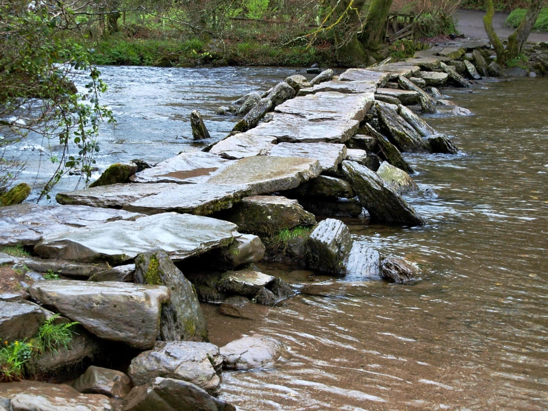
The monument includes Tarr Steps, a 55m long multi-span stone clapper
bridge which crosses the River Barle; it is believed to be of medieval
date and is Listed Grade I.
The Barle rises about 17km to the north west of the clapper bridge and
cuts through a deep wooded valley between Simonsbath and Dulverton. The
bridge is located adjacent to a ford on the single track road which
connects the villages of Hawkridge and Winsford. It is constructed from
rectangular rough-grit sandstone slabs, obtained locally from the Pickwell
Down basement beds, with 17 spans set on stone piers which are raised
about 1m above the river bed. Twelve of the horizontal spanning stones are
single; four are in pairs and one, which forms the end span on the eastern
side, has three parallel stones. The stones are between 2m to 2.9m long,
2m to 1.6m wide and up to 0.3m thick and are supported by piers which are
constructed of dry-stone blocks laid one upon another and set at about 2m
intervals. The average size of the supporting blocks is 2.2m long, 0.7m
wide and 0.7m thick. Each of the piers have up to three stone slabs laid
against them on either side. These appear to act as cutwaters on the
upstream side in order to protect the piers from flood damage and as
supports for the bridge on the downstream side.
Perhaps because of its megalithic character and its proximity to trackways
which are thought to be of Bronze Age date, Tarr Steps has commonly been
believed to date from the prehistoric period. However, recent research has
suggested that it is more likely to be medieval. It is known from
documentary sources that in 1279 the River Barle was crossed by a bridge
at Three Waters, located less than 2km to the south. This suggests Tarr
Steps was not constructed until after 1279 as it would seem unlikely that
two bridges crossing the same river would have co-existed in such close
proximity. Research into similarly constructed clapper bridges on Dartmoor
suggest that they were unlikely to date from before about 1400.
The modern surfacing of the road on the north side of the bridge is
excluded from the scheduling, although the ground beneath it is included.
MAP EXTRACT
The site of the monument is shown on the attached map extract.
Source: Historic England
Clapper bridges are structures designed to carry a trackway across a river
by means of one, or more, large, flat stone slabs, either resting directly
on the river banks or supported on dry stone piers. Many examples comprise
a single slab while multi-span clapper bridges typically have between two
and five spans. They were used by foot passengers and packhorse traffic
and are frequently located on the course of a packhorse track. Although
some clapper bridges are thought to be of prehistoric origin there is no
evidence for this. It may be that surviving prehistoric monuments in the
immediate vicinity of clapper bridges, such as those on Exmoor and
Dartmoor has led to this assumption. It is more likely that clapper
bridges were constructed and used from the late medieval period, around
1400 to the 19th century. They are found in areas of the country where the
local rock yields large slabs of stone. Clapper bridges are very rare
monuments with only just over 40 recorded nationally.
With over 17 spans, Tarr Steps is a highly unusual example of its class of
monument where the typical arrangement is between two and five spans. It
is an important and well known feature of the Exmoor landscape where it is
accessible to the public at all times and continues to perform its
original function of providing a dry route across a river. Tarr Steps has
been described as one of the finest clapper bridges in the country.
Source: Historic England
Books and journals
Grinsell, L V, Archaeology of Exmoor, (1970), 148-150
Jervoise, E, The Ancient Bridges of the South of England, (1930), 112
Other
SS 83 SE 1, National Monuments Record,
Source: Historic England
Other nearby scheduled monuments