Approximate Location Map
Large Map »
This site is entirely user-supported. See how you can help.
Latitude: 54.2326 / 54°13'57"N
Longitude: -0.6788 / 0°40'43"W
OS Eastings: 486218.123055
OS Northings: 482680.646579
OS Grid: SE862826
Mapcode National: GBR RMPH.VH
Mapcode Global: WHGC2.JWZ3
Entry Name: Wilton Hall moated site 250m south of Manor Farm
Scheduled Date: 1 March 1968
Last Amended: 15 April 2004
Source: Historic England
Source ID: 1021269
English Heritage Legacy ID: 35565
County: North Yorkshire
Civil Parish: Wilton
Traditional County: Yorkshire
Lieutenancy Area (Ceremonial County): North Yorkshire
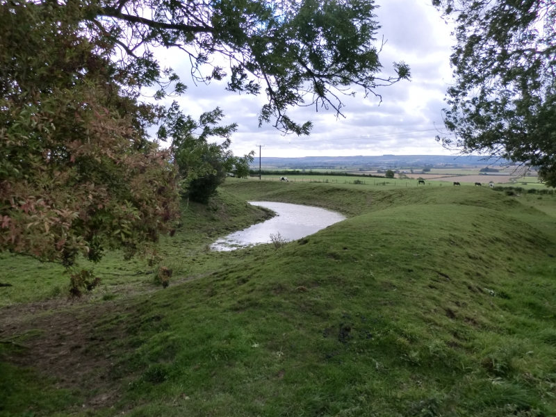
The monument includes a substantial moated site, together with traces of
an outer enclosure and later ridge and furrow. This is one of a number of
defended manor houses along the northern edge of the Vale of Pickering.
Unusually, the defences at Wilton Hall are very substantial, making this
the best preserved moated site in the area. A licence to crenellate was
granted to John de Heslerton in 1335.
The moat itself is roughly circular, averaging 9m across and 2.4m deep,
with an outer bank surviving up to 2m high and 6m wide. The moat survives
well on three sides, but on the north side the moat is overbuilt by the
modern road. Within the moat stands a level platform with a
sub-rectangular shape, measuring roughly 65m by 80m. Traces of masonry
protrude from the ground, including some chamfered ashlar. The inner banks
of the moat also show traces of buried stone revetments.
An excavation in 1975, at the north east corner, revealed evidence of
occupation from the 12th century or earlier. The ditch on the north side
of the site is of 13th century date and smaller than the ditch on the
other three sides, possibly because the village was on this side. The
northern defence line appeared to consist of a substantial mortared wall,
which was part of a building and gatehouse complex. The inner bank
appeared to be of one period, while the outer bank showed two phases. The
northern ditch was open until at least the 14th century, and was later
filled by the levelling of the second phase of the rampart.
Aerial photographs reveal that the moated site was enclosed on at least
three sides by a larger, rectangular enclosure, with a ditch running
roughly 40m beyond the moated site on its west, south and east sides, with
ridge and furrow of `reversed S' type running up to this from the south.
Within the modern field containing the moat, the ridge and furrow
terminated at the outer enclosure ditch, but both of these have now been
flattened by modern ploughing. However, in the next field to the west, the
ridge and furrow continues across the partially-visible ditch and the
interior of the enclosure, and both survive as earthworks. This ridge and
furrow is straighter and more tightly spaced than that further east,
suggesting that this is post-medieval in date.
The churchyard wall, hedges and field gates are excluded from the
scheduling, although the ground beneath them is included. In the centre of
the roadside section of the moated area is a short length of walling,
showing a piece of medieval dressed masonry sandwiched between two lesser
pieces of masonry. All of this masonry is included in the scheduling.
MAP EXTRACT
The site of the monument is shown on the attached map extract.
Source: Historic England
Around 6,000 moated sites are known in England. They consist of wide ditches,
often or seasonally water-filled, partly or completely enclosing one or more
islands of dry ground on which stood domestic or religious buildings. In some
cases the islands were used for horticulture. The majority of moated sites
served as prestigious aristocratic and seigneurial residences with the
provision of a moat intended as a status symbol rather than a practical
military defence. The peak period during which moated sites were built was
between about 1250 and 1350 and by far the greatest concentration lies in
central and eastern parts of England. However, moated sites were built
throughout the medieval period, are widely scattered throughout England and
exhibit a high level of diversity in their forms and sizes. They form a
significant class of medieval monument and are important for the understanding
of the distribution of wealth and status in the countryside. Many examples
provide conditions favourable to the survival of organic remains.
Wilton Hall is one of a series of castles and defended manor houses along
the northern edge of the Vale of Pickering. It is unusual in displaying
earthworks in a good state of preservation, with the moat and bank
surviving on three sides. Protruding masonry and documentary sources
suggest that substantial masonry structures once stood on the inner
platform, and that a gatehouse complex provided access from the north
side, where the settlement stood. Environmental evidence is likely to
survive well in the ditch deposits.
Aerial photographs indicate that the moated site stood within a large
rectangular enclosure, providing a ditched outer bailey, clearly respected
by the ridge and furrow to the south. Further ridge and furrow, probably
of later date, survives to the west and overlying the outer eclosure.
Source: Historic England
Books and journals
The Victoria History of the County of North Riding of Yorkshire, (1923), 438
Farmer, P G, Excavations at Wilton Hall near Thornton Dale, 1975, (1975), 19-25
Farmer, P G, 'Tr Scarborough and Dist A.S.,3,18' in Excavations at Wilton Hall near Thornton Dale, 1975, (1975), 19-25
Other
SF 1703/386 also ANY 89/4 (1980), (1979)
Source: Historic England
Other nearby scheduled monuments