Approximate Location Map
Large Map »
This site is entirely user-supported. See how you can help.
Latitude: 54.2047 / 54°12'17"N
Longitude: -2.1006 / 2°6'1"W
OS Eastings: 393537.895782
OS Northings: 478781.622246
OS Grid: SD935787
Mapcode National: GBR FMST.1G
Mapcode Global: WHB61.PKYY
Entry Name: Packhorse bridge across Crook Gill, 530m south west of Mount Pleasant Farm
Scheduled Date: 8 August 2003
Source: Historic England
Source ID: 1021023
English Heritage Legacy ID: 34726
County: North Yorkshire
Civil Parish: Buckden
Traditional County: Yorkshire
Lieutenancy Area (Ceremonial County): North Yorkshire
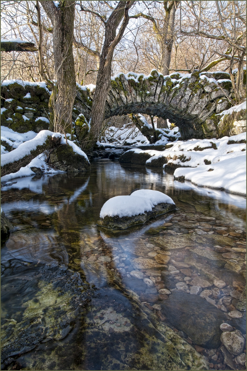
The monument includes a single span packhorse bridge that crosses Crook
Gill just before its confluence with Cray Gill which subsequently joins
the River Wharfe 700m to the south. The bridge lies roughly halfway
between the hamlets of Cray and Hubberholme.
The bridge lies on an old packhorse route from Bishopdale into Wharfedale.
It is constructed of undressed limestone slabs. The single arch is a very
shallow segment with a span of just over 4m. The bridge is about 1.7m wide
and lacks parapets, although some of the arch stones extend upwards to
form an intermittent kerb. The bridge is approached from either side by
roughly built stone causeways each up to approximately 9m long. These are
also included in the monument. The deck of the bridge and causeways are
cobbled.
MAP EXTRACT
The site of the monument is shown on the attached map extract.
It includes a 2 metre boundary around the archaeological features,
considered to be essential for the monument's support and preservation.
Source: Historic England
Medieval and early post-medieval single span bridges are structures designed
to carry a road or track over a river by means of a single arch, typically 3m-
6m in span. They were constructed throughout the medieval period, most
commonly using timber. Stone began to be used instead of timber in the 12th
century and became increasingly common in the 14th and 15th centuries. Many
medieval bridges were repaired, modified or extensively rebuilt in the post-
medieval period. During the medieval period the construction and maintenance
of bridges was frequently carried out by large estates and the Church,
especially monastic institutions which developed long distance packhorse
routes between their landholdings. Some stone built medieval bridges still
survive. These can be classified into three main types based on the profile of
the arch which is typically pointed, semi-circular or flattened. A common
medieval feature is the presence of stone ashlar ribs underneath the arch. The
bridge abutments and revetting of the river banks also form part of the
bridge. Where medieval bridges have been altered in later centuries, original
features are sometimes concealed behind later stonework, including remains of
earlier timber bridges. Bridges were common and important features of medieval
towns and the countryside and allowed easy access along a well developed road
and trackway system. However, only around 16 largely unaltered medieval single
span bridges have so far been recognised to survive in England. All these are
considered to be of national importance. A larger number retain significant
medieval or post-medieval remains, allowing the original form of the bridge to
be determined. These examples are also nationally important.
The bridge across Crook Gill is a good, unmodified example of a typical
packhorse bridge. It retains the character of similar rustic bridges built
from the late medieval period onwards. Unlike many such bridges in the county,
it has not been redecked in modern materials or had parapets added.
Source: Historic England
Books and journals
Hinchcliffe, F A , A Guide to the Packhorse Bridges of England, (1994)
Source: Historic England
Other nearby scheduled monuments