Approximate Location Map
Large Map »
This site is entirely user-supported. See how you can help.
Latitude: 51.702 / 51°42'7"N
Longitude: -0.019 / 0°1'8"W
OS Eastings: 536988.910213
OS Northings: 202221.171865
OS Grid: TL369022
Mapcode National: GBR KCZ.809
Mapcode Global: VHGQ2.MH92
Entry Name: World War II Bofors Anti-aircraft gun platform 340m south east of Cheshunt railway station
Scheduled Date: 15 April 2004
Source: Historic England
Source ID: 1021000
English Heritage Legacy ID: 32470
County: Hertfordshire
Electoral Ward/Division: Cheshunt South and Theobalds
Built-Up Area: Cheshunt
Traditional County: Hertfordshire
Lieutenancy Area (Ceremonial County): Hertfordshire
Church of England Parish: Cheshunt
Church of England Diocese: St.Albans
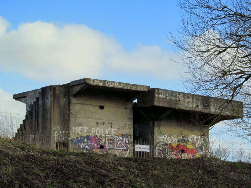
The monument includes a World War II Bofors Anti-aircraft gun platform
overlooking the Lee Valley Navigation canal to the west, and the lakes of the
Lee Valley Country Park to the east.
The platform is of concrete construction and conforms to the Directorate of
Fortifications and Works design DFW 55087, which is an early type, the first
examples of which were produced during the spring or early summer of 1940. The
tower was designed to raise a 40mm Bofors gun and its operational equipment
above surrounding obstacles in order to achieve an all-round field of fire.
The emplacement includes two parallel, independent towers approximately 6m
tall, separated for much of their height by a 1.5m gap and fanning out at roof
level to form two large flat platforms set 0.3m apart. The gap was needed to
insulate the sensitive predictor equipment (sited on one platform) from the
vibrations of the Bofors gun (sited on the other). The northern platform
is rectangular in shape, measuring 3.82m by 6.43m, and has a number of holes
forming a rectangular pattern in the roof. Contemporary photographs show that
these would have served to secure, with bolts, a steel tank to the roof to
afford protection to the emplacement commander and crew operating the
predictor equipment. The southern platform is approximately 6 sq m and housed
the Bofors gun itself; the gun mounting ring is still in place in the centre
of the platform with eight fixing bolts in position. At each corner of the
roof are recesses for the storage of up to 400 rounds of ammunition. Two
rectangular openings (originally with steel shutters of which the frames and
hinges remain) facilitated the supply of ammunition from the upper room of
the northern tower (which housed most of the ammunition in a series of shelves
and lockers) to the gunners. Each tower has two rooms; an external concrete
staircase provides access from the ground floor to the first floor ammunition
store in the northern tower and then up to the roof. At ground level the
northernmost tower has a pillbox-type room with a single loophole and low
ceiling.
The southern tower has two high-ceilinged rooms at ground level; one has a
large number of vents and rectangular openings and most probably housed the
generator; the other room functioned as a general operations room. Both rooms
have loopholes for defence with light weapons.
Photographs in a contemporary magazine article published in November 1943 show
the gun operated by its crew of four, plus an officer manning the telephone, a
spotter scanning the sky with binoculars and two further crew members in
position protected within the steel tank. In one photograph supplies are being
ferried across the River Lee navigation canal to the emplacement.
MAP EXTRACT
The site of the monument is shown on the attached map extract.
It includes a 3 metre boundary around the archaeological features,
considered to be essential for the monument's support and preservation.
Source: Historic England
Although of comparatively recent date, 20th century military sites are
increasingly seen as historic survivals representing a defining episode in the
history of warfare and of the century in general; as such they merit careful
record and, in some cases, preservation. One of the more significant
developments in the evolution of warfare during this period was the emergence
of strategic bombing in World War II, and this significance was reflected by
the resources invested in defence, both in terms of personnel and the sites on
which they served. During the war, the number of people in Anti-aircraft
Command reached a peak of 274,900 men, additional to the women soldiers of the
ATS who served on gunsites from summer 1941, and the Home Guard who manned
many sites later in the war. A national survey of England's Anti-aircraft
provision, based on archive sources, has produced a detailed record of how
many sites there were, where they were and what they looked like. It is also
now known from a survey of aerial photographs how many of these survive.
Anti-aircraft gunsites divide into three main types: those for heavy guns
(HAA), light guns (LAA) and batteries for firing primitive unguided rockets
(so called ZAA sites). In addition to gunsites, decoy targets were employed to
deceive enemy bombers, while fighter command played a complementary and
significant role.
The LAA sites used a range of weapons in defence against lower flying
aircraft, and have a particularly wide distribution around the south and east
coasts and close to cities and industrial and military targets such as
airfields. Of all the gunsites, these were the least substantial, with the
fabric depending to a large extent on the type of weapon employed. The Bofors
machine gun was the weapon most frequently provided with a static emplacement.
It was also the only LAA weapon whose associated structures were covered by
formal design drawings, the remainder taking the form of simple fieldwork
dugouts, at most making use of concrete blocks for revetments. The Bofors gun
had three varieties of emplacement: ground level fieldworks, which were the
most common; roof mountings; and towers of steel or concrete. These towers
were never very numerous, with only 81 concrete examples supplied for use.
These static Bofors sites were sometimes provided with on-site magazines, the
design being left to local initiative. Remote positions for all types of gun
were often provided with a few ancillary structures or domestic buildings,
sufficient only to cater for their crew of 12 men, while ground defences were
modest. The on-site magazines were often Anderson shelters adapted for the
purpose. With few exceptions, sites were therefore small, slight and highly
diverse.
Nearly 1,250 LAA gunsites are recorded as having been built during World War
II and can be accurately located. Around 50 of these have some remains
surviving, though at only around 40 sites are these thought sufficient to
provide an understanding of their original form and function. Surviving
examples are therefore sufficiently rare to suggest that all 40 examples are
of national importance.
The World War II Bofors Anti-aircraft gun platform 340m south east of Cheshunt
railway station is one of only a few survivals of its type in the country. As
such, it is an important historical structure, serving as a physical record of
similar emplacements which have been demolished elsewhere. It provides a
significant, visible reminder of the nature of home defence during World War
II and gives an insight into the development of anti-aircraft measures in the
region around Waltham Abbey.
Source: Historic England
Books and journals
Dobinson, C S, Twentieth Century Fortifications in England: Anti-aircraft artillery, 1914-46, (1996), 166-7
Other
4 frames, War Illustrated, (1943)
Nash, F, Colour prints in ESMR, (1999)
Source: Historic England
Other nearby scheduled monuments