Approximate Location Map
Large Map »
This site is entirely user-supported. See how you can help.
Latitude: 51.625 / 51°37'29"N
Longitude: 0.912 / 0°54'43"E
OS Eastings: 601661.71
OS Northings: 195813.3898
OS Grid: TR016958
Mapcode National: GBR SRG.3DG
Mapcode Global: VHKHB.RFJ4
Entry Name: World War II minefield control tower 940m and pillbox 980m south east of Holliwell Farm
Scheduled Date: 15 April 2004
Source: Historic England
Source ID: 1020997
English Heritage Legacy ID: 32466
County: Essex
Civil Parish: Burnham-on-Crouch
Traditional County: Essex
Lieutenancy Area (Ceremonial County): Essex
Church of England Parish: Burnham-on-Crouch St Mary the Virgin
Church of England Diocese: Chelmsford
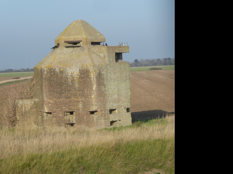
The monument is situated on the Dengie Peninsula 940m and 980m south east of
Holliwell Farm. It includes a fortified observation tower and a double-ended
pillbox, both at the mouth of the River Crouch on its northern bank, enclosed
within two separate areas of protection. The tower stands on the edge of an
open field adjacent to the sea wall; the pillbox is built into the sea wall
some 15m to the south east of the tower.
In 1941 the main function of both structures was to control the estuary
minefield which defended the River Crouch at this point. The observation tower
is a two-storey hexagonal tower, constructed of concrete and brick with walls
0.6m thick, measuring 14m by 10m in plan and 10m high, surmounted by a cupola.
The lower level was easily defended with a single entrance, complete with
steel door, in its western side. A total of 17 machine gun apertures at two
different heights give a 360 degree defensive capability. The apertures
originally had steel shutters which could be closed when under sustained
attack; two of these are still in place.
The upper floor (measuring 5m at its widest point) is reached from below by an
open hatchway and has a high pyramidal ceiling with the concrete cupola
forming its apex. The upper floor has a number of defensive positions: a
concrete platform gives access to a high look-out slot in the southern wall
which affords a view across the whole of the mouth of the River Crouch; the
cupola has a firing slot in each of its six sides, giving all-round views
across the surrounding flat landscape. All of the firing slots in the cupola
have steel shutters which could be closed when under direct attack.
The pillbox is built into the sea wall and has apertures both facing the
estuary and facing the control tower which lies 15m inland. The seaward,
southern end, has the entrance and five gun apertures, one of which retains
its original steel flap. At the landward, northern end, there are three
apertures looking back towards the control tower. The whole structure is 15m
long by 5m wide, with its long axis orientated north east-south west,
bisecting the sea wall.
In 1940, after the German occupation of France, Burnham-on-Crouch became of
serious interest to both the Royal Navy and the British Army as a possible
scene of an attempted landing by enemy forces seeking to find a short and
undefended passage to London. The River Crouch offered just such a passage,
by-passing the main defences of the Rivers Thames and Medway.
The pillbox at Holliwell Point was one of a number of military pillboxes
constructed at the beginning of the War as a vital component of the coastal
defences. In 1940 the Royal Navy sought to strengthen the coastal defences by
laying mines in the estuary. In July 1940 approval was given for warheads,
connected to electrical firing, to be laid as mines, pending the supply of a
more permanent minefield; the electrical firing equipment was set up in the
already existing pillbox. In August 1940 at a conference held at Admiralty
House, Chatham, it was decided to lay eleven groups of three mines each to
supplement the warheads already at Holliwell Point. In June 1941 the
control tower was built, together with the quarters for a complement of two
Royal Naval Volunteer Reserve Officers, six wiremen and sixteen Royal Marines
as guards. On the 15th November 1941 the accommodation block was seriously
damaged by the explosion of a parachute mine, one of four dropped by enemy
aircraft. With the threat of a German invasion a constant concern for most of
the wartime period, and the River Crouch providing a potential access point,
the minefield control tower continued to be manned for the duration of the
War.
All modern fences, fence posts and concrete culverts associated with the sea
wall are excluded from the scheduling, although the ground beneath them is
included.
MAP EXTRACT
The site of the monument is shown on the attached map extract.
It includes a 2 metre boundary around the archaeological features,
considered to be essential for the monument's support and preservation.
Source: Historic England
In the years prior to the outbreak of World War II Burnham-on-Crouch was of
little significance to the Royal Navy, although a small minefield had been
laid in the estuary during World War I. However, after the German occupation
of France, this comparatively small yachting centre suddenly aquired a greater
significance, representing a possible landing point for enemy forces seeking
a short and undefended route to London. In 1940 the British Army had already
constructed a series of pillboxes along the sea wall as part of its coastal
defence scheme (which also included measures such as anti-aircraft gunsites
and bombing decoys). The Royal Navy sought to make the River Crouch
inaccessible to enemy invasion craft (at that time the river would have
admitted vessels of up to 22 feet(6.7m) draught) and constructed a floating
boom defence of wire ropes and buoys. The next step was to lay mines in the
estuary at the gateway to the boom defence. The two wartime structures at
Holliwell Point give testimony to this particular and most important aspect of
the defensive scheme.
Built in 1940 the pillbox predates the minefield control tower. Originally one
of a series of manned defensive pillboxes along the coast, it undertook a more
specialised role in housing the firing equipment for the original two warheads
deployed at Holliwell Point. With the expansion of the minefield in 1941 the
impressive control tower was purpose-built. This is a highly unusual
structure, unique in England. The only other surviving example of a
purpose-built minefield control tower in the British Isles overlooks the Sound
of Kerrera, 4.8km south of Oban in Scotland.
The minefield control tower survives in particularly good condition and
provides a unique record of the architecture and design of this type of
combined observation/control post. The pillbox is its improvised forerunner
and has an important role to play in illustrating the evolution of the full
complement of defensive schemes employed here. Together the two structures
provide a graphic illustration of the threat, acutely felt at the time, of the
impending German invasion.
Source: Historic England
Books and journals
War Time Contraventions, (1968)
Foynes, J P, The Battle of the East Coast (1939-1945), (1994), 253
Foynes, J P, The Battle of the East Coast (1939-1945), (1994), 253
Kent, P, Fortifications of East Anglia, (1988), 67
Nash, F, 'After the Battle' in World War Two Defences in Essex, , Vol. 116, (2002), 30-5
Other
2.4.93 colour prints, Rogers, P, 748-3, 4, (1993)
2.4.93, Rogers, P, 748-3, 4, (1993)
Black and white print, Strachan, D, BW/99/25/1, (1999)
Nash, F, 1 Frame in ECHR, (1995)
Nash, F, 7 Frames, (1995)
Part of document on HMS Leigh;in ESMR, Captain CR Dane, Burnham-on-Crouch (R.N.O. Burnham) June 1940-June 1945, (1940)
Part of document on HMS Leigh;in ESMR, Dane, C R, Burnham-On-Crouch (R.N.O. Burnham) June 1940-June 1945, (1940)
Strachan, D, BW/99/25/1, (1999)
Source: Historic England
Other nearby scheduled monuments