Approximate Location Map
Large Map »
This site is entirely user-supported. See how you can help.
Latitude: 55.3495 / 55°20'58"N
Longitude: -1.61 / 1°36'36"W
OS Eastings: 424825.217203
OS Northings: 606230.532287
OS Grid: NU248062
Mapcode National: GBR K66L.75
Mapcode Global: WHC1T.7SKW
Entry Name: Warkworth Bridge and defensive gateway
Scheduled Date: 6 April 1929
Last Amended: 28 January 2003
Source: Historic England
Source ID: 1020741
English Heritage Legacy ID: 24595
County: Northumberland
Civil Parish: Warkworth
Built-Up Area: Warkworth
Traditional County: Northumberland
Lieutenancy Area (Ceremonial County): Northumberland
Church of England Parish: Warkworth St Lawrence
Church of England Diocese: Newcastle
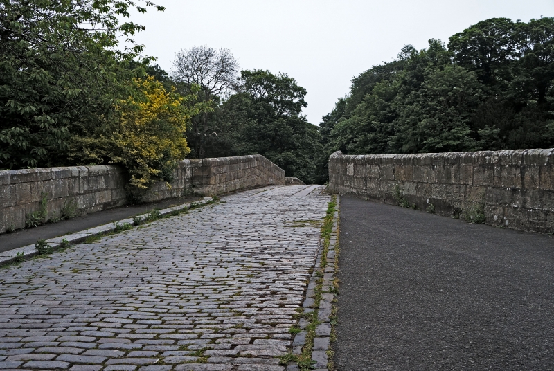
The monument includes the above and below ground remains of Warkworth
Bridge, a multi-span bridge of late 14th century date over the River
Coquet, and the remains of a defensive gateway. The bridge has been closed
to vehicular traffic since the 1960s but is still open to pedestrians. The
bridge and defensive tower are Listed Grade II. The bridge measures 43m
long between land piers, with an overall length of 61m, by 3.5m wide
between the parapet walls. The bridge, built of squared and coursed
sandstone, has two segmental ribbed arches, each with a span of 18.4m. The
central pier has a triple chamfered plinth, and the north and south
abutments have a single chamfered plinth. To counteract the abrasive
action around the bridge foundations the river bed beneath the southern
arch is paved with stone blocks set between lines of timber piles. The
addition of upstream and downstream cutwaters, or triangular projections,
to the central pier also aids the flow of water. The cutwaters are carried
up to parapet level and form niches into which pedestrians could retreat.
The angles between the faces of the cutwater and the bridge parapets are
spanned by short intermediate sections of wall, overhanging the angle
below, and carrying drains with stone spouts. The parapets have been
rebuilt in the 20th century. At the south end of the bridge two wing walls
extend for several metres: the eastern wall measures 19m long and ends in
a stone pier; the western wall measures 18m long and links to the
defensive gateway.
At the south end of the bridge is a defensive gateway of 14th century
date, constructed of large squared stone with cut dressings. It is
rectangular in plan and measures 8.3m by 5.5m externally and stands about
8m tall. The entrance is through an archway opening into the gate passage,
3.5m wide, covered with a stone vault. On the west side of the gate
passage there is an arched opening, with a studded door, into a guard
chamber. The chamber, which measures 3.7m by 1.9m, has a stone bench at
the north end, is lit by a slit at each end, and is covered by a stone
vault. On the east side of the gate passage is a similar arched opening,
with a door, to a spiral staircase for access to an upper room; here the
wall is 1.5m thick, elsewhere the walls are about 0.7m thick. The upper
floor, which measures 6.85m by 4.7m, was lit by windows in all four walls
and, although partly restored in the 19th century, remains roofless.
Traces of the windows can be seen on the north and south external
elevations. On each of the east and west external elevations is a square
headed chamfered narrow window, with a stone spout below that on the east.
The room is said to have had a fireplace and three roof corbels but these
are not visible today.
Documentary evidence records that John Cook of Newcastle, who died in
1378-9, left 20 marks towards the building of Warkworth Bridge on the
condition it was built within two years. Documents also indicate that the
bridge was in the charge of wardens from at least the 15th century; a
`custodes pontis' was recorded in 1498 and bridge master in 1726. There is
said to have been a cross on the east refuge of the bridge until about
1830 but this is now lost.
All fence posts, seating, and the stone wall running from the west side of
the gatehouse towards the river are excluded from the scheduling, although
the ground beneath these features is included.
MAP EXTRACT
The site of the monument is shown on the attached map extract.
Source: Historic England
Multi-span bridges are structures of two or more arches supported on
piers. They were constructed throughout the medieval period for the use
of pedestrians and packhorse or vehicular traffic, crossing rivers or
streams, often replacing or supplementing earlier fords. During the early
medieval period timber was used, but from the 12th century stone (and
later brick) bridges became more common, with the piers sometimes
supported by a timber raft. Most stone or brick bridges were constructed
with pointed arches, although semicircular and segmental examples are also
known. A common medieval feature is the presence of stone ashlar ribs
underneath the arch. The bridge abutments and revetting of the river banks
also form part of the bridge. Where medieval bridges have been altered in
later centuries, original features are sometimes concealed behind later
stonework, including remains of earlier timber bridges. The roadway was
often originally cobbled or gravelled. The building and maintenance of
bridges was frequently carried out by the church and by guilds, although
landowners were also required to maintain bridges. From the mid-13th
century the right to collect tolls, known as pontage, was granted to many
bridges, usually for repairs; for this purpose many urban bridges had
houses or chapels on them, and some were fortified with a defensive
gateway. Medieval multi-span bridges must have been numerous throughout
England, but most have been rebuilt or replaced and less than 200 examples
are now known to survive. As a rare monument type largely unaltered,
surviving examples and examples that retain significant medieval and post-
medieval fabric are considered to be of national importance.
Warkworth Bridge and defensive gateway are well-preserved, having
been by-passed for vehicular traffic by the construction of the modern
bridge immediately downstream. The bridge is believed to be the only
surviving fortified bridge in England. As one of several medieval
monuments which survive in Warkworth, its importance is enhanced by its
relationship to these, and to the preserved layout of the medieval town.
Source: Historic England
Books and journals
Ryder, P, Sermon, R, Historic Bridges in Northumberland, (1993)
Other
5411 and 5413,
Source: Historic England
Other nearby scheduled monuments