Approximate Location Map
Large Map »
This site is entirely user-supported. See how you can help.
Latitude: 52.804 / 52°48'14"N
Longitude: 1.3787 / 1°22'43"E
OS Eastings: 627839.070504
OS Northings: 328287.126428
OS Grid: TG278282
Mapcode National: GBR WFR.7D3
Mapcode Global: WHMSQ.4SS8
Entry Name: Cross 120m south west of Tollgate Farm
Scheduled Date: 12 November 1928
Last Amended: 10 June 1998
Source: Historic England
Source ID: 1018306
English Heritage Legacy ID: 31141
County: Norfolk
Civil Parish: North Walsham
Traditional County: Norfolk
Lieutenancy Area (Ceremonial County): Norfolk
Church of England Parish: Walsham North St Nicholas
Church of England Diocese: Norwich
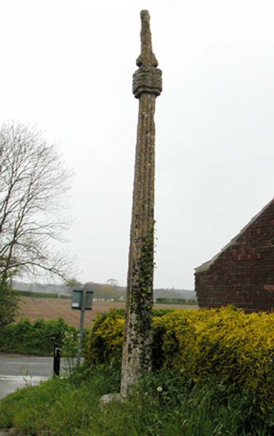
The monument includes a medieval standing stone cross located 120m south west
of Tollgate Farm on the parish boundary between North Walsham and Worstead.
The cross, which is Listed Grade II, includes the socket stone, the shaft, the
capital and the remains of the head. The socket stone is 0.7m square at the
base and 0.36m in height, rising through chamfered corners with stop angles to
an octagonal section on the surface. The shaft, which is mortised into the
socket stone and bonded with mortar, is square in section with rounded corners
and decorated with roll moulding. It measures 0.26m square at the base and
tapers upwards to a height of about 4m. Resting on top of the shaft is the
restored capital. This is quatrefoil in section with horizontal moulding and
measures about 0.26m square by 0.35m high. The capital supports the head,
which although now very worn, is thought originally to have represented the
figure of Christ. The head which faces west, measures about 0.6m in height
tapering upwards from about 0.3m wide at the base to 0.1m wide at the top. The
full height of the cross is about 5.31m.
This cross together with one 300m to the south west (the subject of a separate
scheduling) are thought to relate to the battle at which Henry le Despencer,
Bishop of Norwich, crushed the 1381 Peasant's Revolt lead by Jack Lytester. It
is traditionally believed that one or both crosses were set up after the
battle.
The kerb and the surface of the road to the south of the cross are excluded
from the scheduling, although the ground beneath them is included.
MAP EXTRACT
The site of the monument is shown on the attached map extract.
It includes a 1 metre boundary around the archaeological features,
considered to be essential for the monument's support and preservation.
Source: Historic England
A standing cross is a free standing upright structure, usually of stone,
mostly erected during the medieval period (mid 10th to mid 16th centuries AD).
Standing crosses served a variety of functions. In churchyards they served as
stations for outdoor processions, particularly in the observance of Palm
Sunday. Elsewhere, standing crosses were used within settlements as places for
preaching, public proclamation and penance, as well as defining rights of
sanctuary. Standing crosses were also employed to mark boundaries between
parishes, property, or settlements. A few crosses were erected to commemorate
battles. Some crosses were linked to particular saints, whose support and
protection their presence would have helped to invoke. Crosses in market
places may have helped to validate transactions. After the Reformation, some
crosses continued in use as foci for municipal or borough ceremonies, for
example as places for official proclamations and announcements; some were the
scenes of games or recreational activity.
Standing crosses were distributed throughout England and are thought to have
numbered in excess of 12,000. However, their survival since the Reformation
has been variable, being much affected by local conditions, attitudes and
religious sentiment. In particular, many cross-heads were destroyed by
iconoclasts during the 16th and 17th centuries. Less than 2,000 medieval
standing crosses, with or without cross-heads, are now thought to exist. The
oldest and most basic form of standing cross is the monolith, a stone shaft
often set directly in the ground without a base. The most common form is the
stepped cross, in which the shaft is set in a socket stone and raised upon a
flight of steps; this type of cross remained current from the 11th to 12th
centuries until after the Reformation. Where the cross-head survives it may
take a variety of forms, from a lantern-like structure to a crucifix; the more
elaborate examples date from the 15th century. Much less common than stepped
crosses are spire-shaped crosses, often composed of three or four receding
stages with elaborate architectural decoration and/or sculptured figures; the
most famous of these include the Eleanor crosses, erected by Edward I at the
stopping places of the funeral cortege of his wife, who died in 1290. Also
uncommon are the preaching crosses which were built in public places from the
13th century, typically in the cemeteries of religious communities and
cathedrals, market places and wide thoroughfares; they include a stepped base,
buttresses supporting a vaulted canopy, in turn carrying either a shaft and
head or a pinnacled spire. Standing crosses contribute significantly to our
understanding of medieval customs, both secular and religious, and to our
knowledge of medieval parishes and settlement patterns. All crosses which
survive as standing monuments, especially those which stand in or near their
original location, are considered worthy of protection.
The cross 120m south west of Tollgate Farm is a good example of a medieval
standing cross. It survives particularly well with a square to octagonal
socket stone, a tapering moulded shaft, an elaborate capital and a head which
is thought to represent Christ. Situated close to the site of the 1381 battle
between Henry le Despencer and the peasants, this cross is believed to stand
in or near its original position, and its traditional association with the
commemoration of the battle and its association with another standing cross
300m to the south west gives it additional interest. The cross has not been
significantly restored and has continued in use as a public monument and
amenity from medieval times until the present day.
Source: Historic England
Books and journals
Cozens-Hardy, , 'Norfolk Archaeology' in Norfolk Crosses, , Vol. 25, (1935), 327
Other
FMW report, Corbishley, M J, SAM NF 197b, (1983)
Rose, E, 7568, (1978)
Source: Historic England
Other nearby scheduled monuments