Approximate Location Map
Large Map »
This site is entirely user-supported. See how you can help.
Latitude: 53.6001 / 53°36'0"N
Longitude: -0.5407 / 0°32'26"W
OS Eastings: 496669.481534
OS Northings: 412489.748744
OS Grid: SE966124
Mapcode National: GBR SVNT.R6
Mapcode Global: WHGG7.NRRZ
Entry Name: Thornholme Augustinian priory
Scheduled Date: 17 January 1966
Last Amended: 24 July 1998
Source: Historic England
Source ID: 1017821
English Heritage Legacy ID: 30125
County: North Lincolnshire
Civil Parish: Appleby
Traditional County: Lincolnshire
Lieutenancy Area (Ceremonial County): Lincolnshire
Church of England Parish: Appleby St Bartholomew
Church of England Diocese: Lincoln
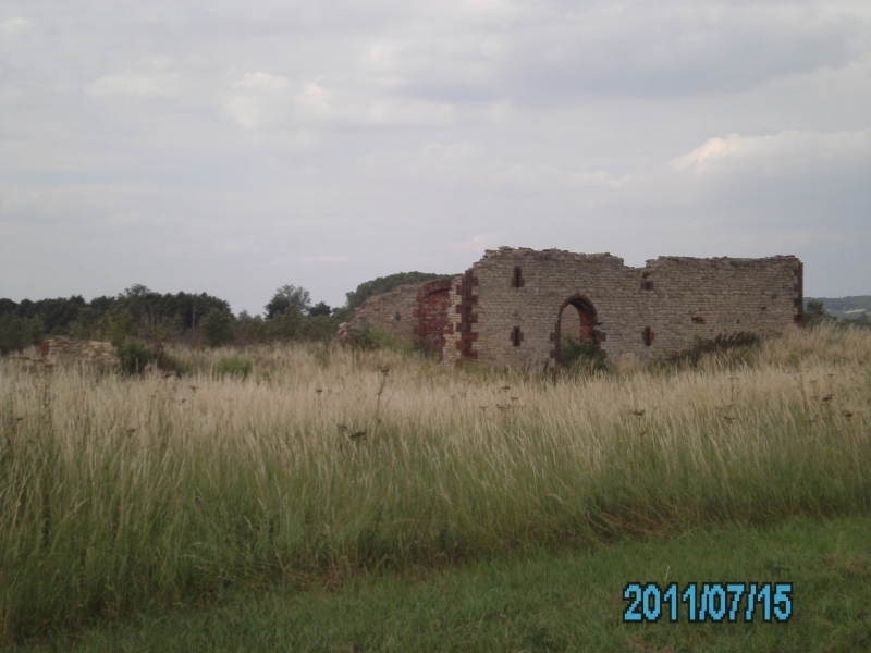
The monument includes the buried and earthwork remains of Thornholme Priory,
including the church, cloister and other inner court buildings as well as the
service buildings of the outer court. It is divided into two areas of
protection by the West Drain.
The Priory of the Blessed Virgin Mary at Thornholme was founded by King
Stephen between 1148 and 1154 for about 12 Augustinian canons on a small
island on the western edge of the Ancholme valley. Patronage passed to John
Malherbe by 1202 so that later in 1271-72, when one of his descendants, Hugh
de Nevill of Cadney was patron, the prior acknowledged John Malherbe as
founder. Thornholme was not one of the wealthiest of priories, but it had a
respectable income which was valued at one hundred and fifty-seven pounds by a
papal taxation assessment of 1291. This, along with the assessments for
several other institutions, was later admitted to have been too high, and is
thought to have been around one hundred and twenty pounds in reality. Both
documentary and archaeological evidence shows that the priory expanded after
its foundation. Before the Black Death of the mid-14th century, the number of
canons is thought to have reached 18 or more, but this had fallen to 14 in
1377 and nine in 1440. Bishop William Alnwick visited the priory in 1440 and
recorded the presence of a number of buildings, including an infirmary, guest
chambers and granaries as well as the expected church, cloister and
chapterhouse. Mention is also made of fisheries, a separate house for the
prior, as well as oblique references to a prison and houses for at least two
permanent guests. The prior and nine canons subscribed to the King's
supremacy, acknowledging Henry VIII as the Head of the Church, in 1534 and the
priory was suppressed in 1536, when its income was assessed at one hundred and
forty-nine pounds, twelve shillings and six and a half pennies.
Unlike many priories and monasteries, Thornholme did not become the site of a
country house after the Dissolution, and diarists of the late 17th century
mentioned that substantial standing remains of the priory still survived over
a century later. By the late 17th century a small farm was established on the
site, centred to the north west of the church. This farm was ruinous by 1954.
Throughout the medieval period, before later drainage works, the River
Ancholme was tidal as far inland as Brigg, and Thornholme would have been an
island surrounded by marsh and open water. A series of archaeological
excavations between 1974 and 1980 demonstrated that over the centuries of use,
the land surface of the island was raised with a succession of buildings built
on top of the remains of their predecessors. This island can now be seen as an
area of higher land with an embanked railway line running along its southern
side, crossed WSW to ENE by a trackway and NNW to SSE by a drainage dyke, the
West Drain, which was in existence by 1836.
The main part of the priory lies to the east of West Drain, mostly to the
south of the trackway. The priory church is cruciform in plan, about 65m long
and 25m across at the transepts, with the modern trackway running along the
south side of the nave and chancel. Earthwork evidence implies that the church
had a substantial tower at the west end. The north transept was investigated
archaeologically in 1975-76, excavating disturbed deposits but leaving the
substantial in situ remains in place. This demonstrated that the priory had
both glazed and unglazed windows, a leaded roof, and areas of tiled flooring.
The walls, which had been rebuilt at least once, included reused stones and
were plastered both internally and externally. To the south of the nave and
south transept there are the substantial earthwork remains of the cloister and
other related buildings. The cloister itself is about 22m-23m square. The east
range, which runs south from the south transept, survives as a set of
earthworks about 45m long, 10m wide and in places over 2m high. The
substantial west range, which is at least partly brick built, the refectory
forming the south side of the cloister and the large kitchen in the south east
corner all survive as clear upstanding earthworks. To the south of the
cloister, extending towards West Drain, there are the earthworks of boundary
walls and small isolated buildings that are interpreted as being the remains
of service yards. Further to the south and south west there are a complex set
of depressions and water filled ponds which are partly overlain to the south
by the railway embankment. These, especially the group to the east which
includes a small island, are interpreted as ponds used for the management of
water-fowl. This is supported by a documentary reference to a legal suit over
the theft of 30 brood swans from the priory in 1374. To the east of the
cloister, set within a large walled enclosure, there are the buried remains of
a large east-west building up to 30m by 10m which has been identified as the
infirmary together with a smaller, but substantial building 10m to the south
west interpreted as the infirmary's kitchen. To the east of the infirmary
enclosure the ground surface drops away and would have been at great risk of
flooding during the medieval period. Three ditched enclosures, two containing
the remains of stone buildings, have been identified in this area with finds
of 12th and 13th century date. Immediately to the north west of the church,
north of the trackway, there are the standing and earthwork remains of the
later farm buildings which were partly built with reused stone from the
priory. The farm was built in an open area which is thought to have been the
priory's cemetery. An outlying cart shed for this farm was built over part of
the nave of the church. Around 40m to the north of this complex there are the
earthwork remains of a further group of small stone buildings with the
depression of a drainage ditch beyond.
The west end of the precinct lies to the west of West Drain. This area was
partly excavated in the 1970s and was shown to retain a complex succession of
gatehouses and other service buildings built and modified from at least the
12th century up until the Dissolution. The 12th century levels were left in
situ, were carefully backfilled and will still survive below the maximum depth
of the plough soil. Extending westwards from this area there were a pair of
causeways, built up over the centuries, to provide cart access from the priory
to the Roman Road. The remains of these causeways beyond the boundary of the
adjacent monument are not included within the scheduling as they have been
levelled by ploughing.
A number of features are excluded from the scheduling; these are the railway
line and embankment and all associated railway features, all modern fences,
styles and gates, although the ground beneath all these features is included.
MAP EXTRACT
The site of the monument is shown on the attached map extract.
Source: Historic England
From the time of St Augustine's mission to re-establish Christianity in AD 597
to the reign of Henry VIII, monasticism formed an important facet of both
religious and secular life in the British Isles. Settlements of religious
communities, including monasteries, were built to house communities of monks,
canons (priests), and sometimes lay-brothers, living a common life of
religious observance under some form of systematic discipline. It is estimated
from documentary evidence that over 700 monasteries were founded in England.
These ranged in size from major communities with several hundred members to
tiny establishments with a handful of brethren. They belonged to a wide
variety of different religious orders, each with its own philosophy. As a
result, they vary considerably in the detail of their appearance and layout,
although all possess the basic elements of church, domestic accommodation for
the community, and work buildings. Monasteries were inextricably woven into
the fabric of medieval society, acting not only as centres of worship,
learning, and charity, but also, because of the vast landholdings of some
orders, as centres of immense wealth and political influence. They were
established in all parts of England, some in towns and others in the remotest
of areas. Many monasteries acted as the foci of wide networks including parish
churches, almshouses, hospitals, farming estates and tenant villages. Some 225
of these religious houses belonged to the order of St Augustine. The
Augustinians were not monks in the strict sense, but rather communities of
canons - or priests - living under the rule of St Augustine. In England they
came to be known as `black canons' because of their dark coloured robes and to
distinguish them from the Cistercians who wore light clothing. From the 12th
century onwards, they undertook much valuable work in the parishes, running
almshouses, schools and hospitals as well as maintaining and preaching in
parish churches. It was from the churches that they derived much of their
revenue. The Augustinians made a major contribution to many facets of medieval
life and all of their monasteries which exhibit significant surviving
archaeological remains are worthy of protection.
Thornholme Priory is a good example of a medium sized Augustinian foundation.
It is well preserved with very little post-Dissolution disturbance, with the
core of the priory surviving with substantial upstanding earthworks.
Excavation has shown that much of the site, including those areas ploughed,
retain undisturbed deposits extending over 1m below the modern ground surface.
These deposits also included organic remains.
Source: Historic England
Books and journals
Coppack, G, Hayfield, C, Thornholme Priory: the archaeology of a small Augustinian house, (1998), indexed
Other
SMR record, Humber Archaeological Partnership, 78, (1997)
Source: Historic England
Other nearby scheduled monuments