Approximate Location Map
Large Map »
This site is entirely user-supported. See how you can help.
Latitude: 52.5607 / 52°33'38"N
Longitude: -0.839 / 0°50'20"W
OS Eastings: 478797.777
OS Northings: 296508.5625
OS Grid: SP787965
Mapcode National: GBR BRG.JP4
Mapcode Global: WHFL0.2WQR
Entry Name: Butter Cross 150m east of the church
Scheduled Date: 8 December 1997
Source: Historic England
Source ID: 1017498
English Heritage Legacy ID: 30235
County: Leicestershire
Civil Parish: Hallaton
Built-Up Area: Hallaton
Traditional County: Leicestershire
Lieutenancy Area (Ceremonial County): Leicestershire
Church of England Parish: Hallaton St Michael and All Angels
Church of England Diocese: Leicester
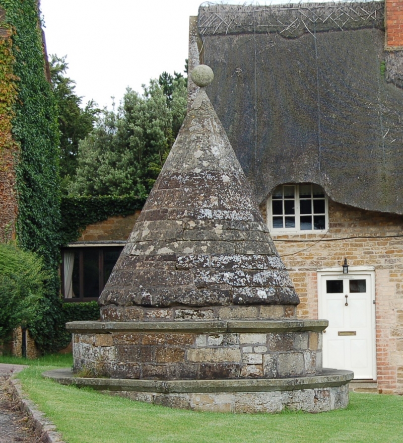
The monument includes the Butter Cross, a standing stone cross of
post-medieval and later date, 150m east of the church. The cross, which is
Listed Grade II*, includes a base of two steps and a conical structure.
The steps are circular in plan and constructed from ironstone ashlar blocks.
The bottom step has a maximum diameter of 3.7m. On the uppermost step stands a
cone of regular coursed stone, measuring 2m in diameter at its base, with a
maximum height of 2m and surmounted by a stone ball finial. The full height of
the cross is 3m. The cross is thought to date from the 17th century, with
modern repairs and refacing, and marks the location of the weekly village
market. Contemporary documentary sources show that a market was first granted
in 1224, which is believed to have lapsed by the late 17th century but was
revived in 1767. The monument is clearly depicted in an 18th century engraving
and described as `the town cross'.
The adjacent kerbstone and the tarmac surface of the road are excluded from
the scheduling, although the ground beneath them is included.
MAP EXTRACT
The site of the monument is shown on the attached map extract.
It includes a 1 metre boundary around the archaeological features,
considered to be essential for the monument's support and preservation.
Source: Historic England
A standing cross is a free standing upright structure, usually of stone,
mostly erected during the medieval period (mid 10th to mid 16th centuries AD).
Standing crosses served a variety of functions. In churchyards they served as
stations for outdoor processions, particularly in the observance of Palm
Sunday. Elsewhere, standing crosses were used within settlements as places for
preaching, public proclamation and penance, as well as defining rights of
sanctuary. Standing crosses were also employed to mark boundaries between
parishes, property, or settlements. A few crosses were erected to commemorate
battles. Some crosses were linked to particular saints, whose support and
protection their presence would have helped to invoke. Crosses in market
places may have helped to validate transactions. After the Reformation, some
crosses continued in use as foci for municipal or borough ceremonies, for
example as places for official proclamations and announcements; some were the
scenes of games or recreational activity.
Standing crosses were distributed throughout England and are thought to have
numbered in excess of 12,000. However, their survival since the Reformation
has been variable, being much affected by local conditions, attitudes and
religious sentiment. In particular, many cross-heads were destroyed by
iconoclasts during the 16th and 17th centuries. Less than 2,000 medieval
standing crosses, with or without cross-heads, are now thought to exist. The
oldest and most basic form of standing cross is the monolith, a stone shaft
often set directly in the ground without a base. The most common form is the
stepped cross, in which the shaft is set in a socket stone and raised upon a
flight of steps; this type of cross remained current from the 11th to 12th
centuries until after the Reformation. Where the cross-head survives it may
take a variety of forms, from a lantern-like structure to a crucifix; the more
elaborate examples date from the 15th century. Much less common than stepped
crosses are spire-shaped crosses, often composed of three or four receding
stages with elaborate architectural decoration and/or sculptured figures; the
most famous of these include the Eleanor crosses, erected by Edward I at the
stopping places of the funeral cortege of his wife, who died in 1290. Also
uncommon are the preaching crosses which were built in public places from the
13th century, typically in the cemeteries of religious communities and
cathedrals, market places and wide thoroughfares; they include a stepped base,
buttresses supporting a vaulted canopy, in turn carrying either a shaft and
head or a pinnacled spire. Standing crosses contribute significantly to our
understanding of medieval customs, both secular and religious, and to our
knowledge of medieval parishes and settlement patterns. All crosses which
survive as standing monuments, especially those which stand in or near their
original location, are considered worthy of protection.
This Butter Cross 150m east of the church, represents a good example of a
medieval or post-medieval Butter Cross. Situated in the former market place,
it is believed to stand in or near its original position and limited activity
in the area immediately surrounding the cross indicates that archaeological
deposits relating to its construction and use in this location will survive
intact. While the majority of the cross is original, its subsequent
restoration and repair illustrates its continued function as a public monument
and amenity.
Source: Historic England
Books and journals
Nichols, J, The History and Antiquities of the County of Leicester, (1805)
Pugh, RB , The Victoria History of the County of Leicester, (1964)
Other
Leicestershire County Council, 79 NE.AU,
Listing Report: 8/86,
RCHME, NMR Long Report: SP 79 NE 2,
Source: Historic England
Other nearby scheduled monuments